| Name | Location | Date Listed | Grid Ref. [note 1] | Geo-coordinates | Notes | LB Number [note 2] | Image |
|---|
|
| Ancaster Square, Rob Roy And Trossachs Visitor Centre (Formerly St. Kessog's Church) | | | | 56°14′39″N4°12′52″W / 56.244201°N 4.214406°W / 56.244201; -4.214406 (Ancaster Square, Rob Roy And Trossachs Visitor Centre (Formerly St. Kessog's Church)) | Category B | 22885 |  |
| 15, 17 And 19 Main Street | | | | 56°14′40″N4°13′00″W / 56.244464°N 4.216794°W / 56.244464; -4.216794 (15, 17 And 19 Main Street) | Category C(S) | 22893 | |
| Bridgend, Bridgend House Hotel | | | | 56°14′33″N4°13′04″W / 56.242398°N 4.217707°W / 56.242398; -4.217707 (Bridgend, Bridgend House Hotel) | Category C(S) | 22899 | 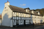 Upload another image
|
| Roman Camp Hotel Walled Garden | | | | 56°14′24″N4°12′29″W / 56.240083°N 4.207987°W / 56.240083; -4.207987 (Roman Camp Hotel Walled Garden) | Category C(S) | 22907 | |
| Loch Katrine, Portnellan, Macgregor Of Glengyle Burial Ground | | | | 56°16′22″N4°34′34″W / 56.272862°N 4.57598°W / 56.272862; -4.57598 (Loch Katrine, Portnellan, Macgregor Of Glengyle Burial Ground) | Category C(S) | 4066 | |
| Callandrade | | | | 56°14′22″N4°13′27″W / 56.239459°N 4.224267°W / 56.239459; -4.224267 (Callandrade) | Category C(S) | 4014 | |
| Glengyle House Including Boundary Walls And Gatepiers | | | | 56°17′09″N4°36′33″W / 56.285846°N 4.609155°W / 56.285846; -4.609155 (Glengyle House Including Boundary Walls And Gatepiers) | Category B | 4024 | |
| Ancaster Road, Ach Na Coile Including Boundary Wall, Railings And Gatepiers | | | | 56°14′45″N4°12′50″W / 56.245757°N 4.213818°W / 56.245757; -4.213818 (Ancaster Road, Ach Na Coile Including Boundary Wall, Railings And Gatepiers) | Category C(S) | 50361 | |
| 10 Ancaster Square (Formerly Lesser St. Kessog's Church Hall) | | | | 56°14′39″N4°12′51″W / 56.24409°N 4.214093°W / 56.24409; -4.214093 (10 Ancaster Square (Formerly Lesser St. Kessog's Church Hall)) | Category C(S) | 50365 | |
| 2, 4 And 6 Bridge Street Including Boundary Wall | | | | 56°14′38″N4°13′00″W / 56.243881°N 4.216728°W / 56.243881; -4.216728 (2, 4 And 6 Bridge Street Including Boundary Wall) | Category C(S) | 50382 | |
| Brig O'Turk, Trossachs Primary School And Schoolhouse | | | | 56°13′55″N4°22′01″W / 56.232048°N 4.366876°W / 56.232048; -4.366876 (Brig O'Turk, Trossachs Primary School And Schoolhouse) | Category C(S) | 50396 | |
| Kilmahog, Pass House | | | | 56°14′58″N4°15′27″W / 56.249396°N 4.257628°W / 56.249396; -4.257628 (Kilmahog, Pass House) | Category C(S) | 50398 | |
| Milepost Near Coilantogle Nn 58958 06493 | | | | 56°13′48″N4°16′37″W / 56.229919°N 4.27686°W / 56.229919; -4.27686 (Milepost Near Coilantogle Nn 58958 06493) | Category C(S) | 50401 | |
| 16, 18 And 20 Ancaster Square Including Outbuilding To 20 | | | | 56°14′37″N4°12′55″W / 56.243675°N 4.215183°W / 56.243675; -4.215183 (16, 18 And 20 Ancaster Square Including Outbuilding To 20) | Category C(S) | 22889 | |
| 2 Bridgend, Teithview | | | | 56°14′33″N4°13′03″W / 56.242546°N 4.21749°W / 56.242546; -4.21749 (2 Bridgend, Teithview) | Category C(S) | 22898 | |
| 1, 2, 3, 4, 5, 6, 7, 8, 9, 10, 11 And 12 Esher Crescent, Scottish Veterans Garden Settlement Including War Memorial To Centre | | | | 56°14′24″N4°11′57″W / 56.239977°N 4.199283°W / 56.239977; -4.199283 (1, 2, 3, 4, 5, 6, 7, 8, 9, 10, 11 And 12 Esher Crescent, Scottish Veterans Garden Settlement Including War Memorial To Centre) | Category B | 22909 | |
| Leny House Walled Garden Including Outbuilding | | | | 56°15′06″N4°14′31″W / 56.251543°N 4.241854°W / 56.251543; -4.241854 (Leny House Walled Garden Including Outbuilding) | Category B | 3980 | |
| Kilmahog Bridge Over Garbh Uisge | | | | 56°14′47″N4°14′52″W / 56.246449°N 4.247706°W / 56.246449; -4.247706 (Kilmahog Bridge Over Garbh Uisge) | Category B | 4021 | |
| South Church Street, Sundial | | | | 56°14′32″N4°12′50″W / 56.242242°N 4.213873°W / 56.242242; -4.213873 (South Church Street, Sundial) | Category C(S) | 47152 | |
| Glengyle House Steading Including Cobbled Yard | | | | 56°17′11″N4°36′30″W / 56.286356°N 4.608415°W / 56.286356; -4.608415 (Glengyle House Steading Including Cobbled Yard) | Category C(S) | 48701 | |
| Ancaster Square, War Memorial To South | | | | 56°14′37″N4°12′53″W / 56.243636°N 4.214825°W / 56.243636; -4.214825 (Ancaster Square, War Memorial To South) | Category C(S) | 50362 | |
| Leny Feus, Callander Lodge Including Robertson House, Lodge And Stable, Boundary Walls, Gatepiers And Garden Features | | | | 56°14′48″N4°13′47″W / 56.246624°N 4.229589°W / 56.246624; -4.229589 (Leny Feus, Callander Lodge Including Robertson House, Lodge And Stable, Boundary Walls, Gatepiers And Garden Features) | Category B | 50383 | |
| 24 Ancaster Square | | | | 56°14′36″N4°12′54″W / 56.24337°N 4.215117°W / 56.24337; -4.215117 (24 Ancaster Square) | Category C(S) | 22891 | |
| Bridgend, Callander Primary School (Formerly Mclaren High School) | | | | 56°14′31″N4°12′59″W / 56.242025°N 4.216459°W / 56.242025; -4.216459 (Bridgend, Callander Primary School (Formerly Mclaren High School)) | Category C(S) | 22900 | |
| 182 Main Street, Roman Camp Gate House Including Boundary Wall, Rustic Arch And Gate | | | | 56°14′31″N4°12′30″W / 56.242011°N 4.208228°W / 56.242011; -4.208228 (182 Main Street, Roman Camp Gate House Including Boundary Wall, Rustic Arch And Gate) | Category C(S) | 22904 | |
| Loch Venachar Dam Including Sluice House, Weir And Fish Ladder (Former Glasgow Corporation Water Works) | | | | 56°13′48″N4°15′48″W / 56.229863°N 4.263271°W / 56.229863; -4.263271 (Loch Venachar Dam Including Sluice House, Weir And Fish Ladder (Former Glasgow Corporation Water Works)) | Category A | 4060 |  Upload another image
|
| Invertrossachs House Including Garden Shelter And Small Enclosed Garden, Tennis Pavilion And Kennels | | | | 56°12′59″N4°19′14″W / 56.216347°N 4.32044°W / 56.216347; -4.32044 (Invertrossachs House Including Garden Shelter And Small Enclosed Garden, Tennis Pavilion And Kennels) | Category C(S) | 4061 | |
| Gart House Including Sunken Formal Garden And Boundary Wall To Nw | | | | 56°13′57″N4°11′39″W / 56.232419°N 4.194235°W / 56.232419; -4.194235 (Gart House Including Sunken Formal Garden And Boundary Wall To Nw) | Category C(S) | 4018 | |
| Glengyle, Macgregor Of Glengyle Burial Enclosure | | | | 56°17′11″N4°36′36″W / 56.286501°N 4.61004°W / 56.286501; -4.61004 (Glengyle, Macgregor Of Glengyle Burial Enclosure) | Category C(S) | 4023 | |
| 8 Ancaster Square | | | | 56°14′38″N4°12′51″W / 56.243999°N 4.214136°W / 56.243999; -4.214136 (8 Ancaster Square) | Category C(S) | 50364 | |
| 24 Main Street, Kinnell House | | | | 56°14′39″N4°13′01″W / 56.244182°N 4.216939°W / 56.244182; -4.216939 (24 Main Street, Kinnell House) | Category C(S) | 50385 | |
| 91 And 93 Main Street | | | | 56°14′36″N4°12′45″W / 56.243335°N 4.212565°W / 56.243335; -4.212565 (91 And 93 Main Street) | Category C(S) | 50389 | |
| Milepost At Nn 52832 06470 | | | | 56°13′41″N4°22′32″W / 56.227938°N 4.375447°W / 56.227938; -4.375447 (Milepost At Nn 52832 06470) | Category C(S) | 50534 | |
| Leny Road, St Andrew's Episcopal Church Including Hall, Boundary Wall, Railings, Gatepiers And Gates | | | | 56°14′43″N4°13′15″W / 56.245235°N 4.22089°W / 56.245235; -4.22089 (Leny Road, St Andrew's Episcopal Church Including Hall, Boundary Wall, Railings, Gatepiers And Gates) | Category B | 22895 | |
| Brig O'Turk Trossachs Parish Church Including Graveyard, Boundary Walls, Gatepiers And Railings | | | | 56°13′45″N4°23′48″W / 56.229163°N 4.39674°W / 56.229163; -4.39674 (Brig O'Turk Trossachs Parish Church Including Graveyard, Boundary Walls, Gatepiers And Railings) | Category C(S) | 4064 | |
| Leny House Sundial | | | | 56°15′06″N4°14′35″W / 56.251676°N 4.242927°W / 56.251676; -4.242927 (Leny House Sundial) | Category B | 3981 | |
| Little Leny, Buchanan Burial Enclosure And Burial Ground At Confluence Of Eas Gobhain And Garbe Usige | | | | 56°14′29″N4°13′32″W / 56.241357°N 4.225652°W / 56.241357; -4.225652 (Little Leny, Buchanan Burial Enclosure And Burial Ground At Confluence Of Eas Gobhain And Garbe Usige) | Category C(S) | 4015 | |
| Kilmahog, Woollen Mill | | | | 56°14′47″N4°14′34″W / 56.246494°N 4.242769°W / 56.246494; -4.242769 (Kilmahog, Woollen Mill) | Category C(S) | 4017 | |
| Kilmahog, Shieldaig | | | | 56°14′47″N4°14′28″W / 56.246396°N 4.241214°W / 56.246396; -4.241214 (Kilmahog, Shieldaig) | Category C(S) | 4019 | |
| North Church Street, Sorisdale Cottage | | | | 56°14′39″N4°12′45″W / 56.244119°N 4.212448°W / 56.244119; -4.212448 (North Church Street, Sorisdale Cottage) | Category C(S) | 50392 | |
| Loch Katrine, Trossachs Pier | | | | 56°14′03″N4°25′48″W / 56.234264°N 4.430122°W / 56.234264; -4.430122 (Loch Katrine, Trossachs Pier) | Category C(S) | 50399 | |
| 1 Ancaster Square/57 Main Street | | | | 56°14′38″N4°12′54″W / 56.243975°N 4.214958°W / 56.243975; -4.214958 (1 Ancaster Square/57 Main Street) | Category C(S) | 22886 | |
| Callander Bridge Over River Teith | | | | 56°14′35″N4°13′02″W / 56.242974°N 4.21716°W / 56.242974; -4.21716 (Callander Bridge Over River Teith) | Category B | 22897 | |
| 22 South Church Street, Waterside Cottage And South Church Street, Airlie Cottage Including Boundary Walls | | | | 56°14′33″N4°12′50″W / 56.242547°N 4.213891°W / 56.242547; -4.213891 (22 South Church Street, Waterside Cottage And South Church Street, Airlie Cottage Including Boundary Walls) | Category C(S) | 22903 | |
| Brig O'Turk | | | | 56°13′44″N4°22′17″W / 56.229023°N 4.371368°W / 56.229023; -4.371368 (Brig O'Turk) | Category B | 4062 | |
| Tigh Mor Trossachs (Former Trossachs Hotel) | | | | 56°13′57″N4°24′07″W / 56.232479°N 4.401852°W / 56.232479; -4.401852 (Tigh Mor Trossachs (Former Trossachs Hotel)) | Category B | 4065 | |
| Ardchullarie More Including Lodge And Motor House/Kennel/ Byre | | | | 56°17′36″N4°17′17″W / 56.293234°N 4.287978°W / 56.293234; -4.287978 (Ardchullarie More Including Lodge And Motor House/Kennel/ Byre) | Category B | 3983 | |
| Kilmahog Graveyard Including Mort House | | | | 56°14′47″N4°14′46″W / 56.246459°N 4.246141°W / 56.246459; -4.246141 (Kilmahog Graveyard Including Mort House) | Category C(S) | 4020 | |
| Leny House Including Gatepiers And Sundial | | | | 56°15′09″N4°14′22″W / 56.252387°N 4.239433°W / 56.252387; -4.239433 (Leny House Including Gatepiers And Sundial) | Category B | 4022 | |
| 38 Main Street (Formerly The Eagle Hotel) | | | | 56°14′38″N4°12′58″W / 56.243963°N 4.216168°W / 56.243963; -4.216168 (38 Main Street (Formerly The Eagle Hotel)) | Category C(S) | 50386 | |
| South Church Street, Callander Kirk Hall (Former Free Church School) Including Low Boundary Wall And Piers | | | | 56°14′34″N4°12′46″W / 56.242915°N 4.212912°W / 56.242915; -4.212912 (South Church Street, Callander Kirk Hall (Former Free Church School) Including Low Boundary Wall And Piers) | Category C(S) | 50393 | |
| Anie Farmhouse | | | | 56°15′47″N4°16′51″W / 56.263109°N 4.280704°W / 56.263109; -4.280704 (Anie Farmhouse) | Category C(S) | 50394 | |
| Bochastle Farm | | | | 56°14′32″N4°14′29″W / 56.242105°N 4.241463°W / 56.242105; -4.241463 (Bochastle Farm) | Category C(S) | 50395 | |
| Milepost Near Trossachs Parish Church Nn 51465 06750 | | | | 56°13′48″N4°23′51″W / 56.23011°N 4.397525°W / 56.23011; -4.397525 (Milepost Near Trossachs Parish Church Nn 51465 06750) | Category C(S) | 50400 | |
| 3 Ancaster Square | | | | 56°14′39″N4°12′54″W / 56.244066°N 4.214883°W / 56.244066; -4.214883 (3 Ancaster Square) | Category C(S) | 22887 | |
| 9 Ancaster Square (Formerly 5, 7 And 9) | | | | 56°14′39″N4°12′53″W / 56.244158°N 4.214791°W / 56.244158; -4.214791 (9 Ancaster Square (Formerly 5, 7 And 9)) | Category C(S) | 22888 | |
| Bridge Street, Callander Churchyard Including Watch House | | | | 56°14′36″N4°13′03″W / 56.243409°N 4.217475°W / 56.243409; -4.217475 (Bridge Street, Callander Churchyard Including Watch House) | Category C(S) | 22896 | |
| 20 South Church Street, Waterside House | | | | 56°14′33″N4°12′50″W / 56.242631°N 4.213767°W / 56.242631; -4.213767 (20 South Church Street, Waterside House) | Category B | 22902 | |
| 192 Main Street, Murdiston House Including Retaining Wall And Railing To N | | | | 56°14′31″N4°12′27″W / 56.241907°N 4.207479°W / 56.241907; -4.207479 (192 Main Street, Murdiston House Including Retaining Wall And Railing To N) | Category B | 22908 | |
| 4A And 8A Ancaster Square | | | | 56°14′38″N4°12′50″W / 56.244022°N 4.213863°W / 56.244022; -4.213863 (4A And 8A Ancaster Square) | Category C(S) | 50363 | |
| 26 Ancaster Square | | | | 56°14′36″N4°12′54″W / 56.243346°N 4.214986°W / 56.243346; -4.214986 (26 Ancaster Square) | Category C(S) | 50367 | |
| Leny Feus, Trean House | | | | 56°14′49″N4°13′51″W / 56.246981°N 4.23074°W / 56.246981; -4.23074 (Leny Feus, Trean House) | Category B | 50384 | |
| 101 Main Street, The Crags Hotel | | | | 56°14′35″N4°12′43″W / 56.243184°N 4.211991°W / 56.243184; -4.211991 (101 Main Street, The Crags Hotel) | Category C(S) | 50390 | |
| 5 Main Street, The Old Bank (Formerly National Commercial Bank) | | | | 56°14′41″N4°13′03″W / 56.24465°N 4.217434°W / 56.24465; -4.217434 (5 Main Street, The Old Bank (Formerly National Commercial Bank)) | Category C(S) | 22894 | |
| Roman Camp Hotel Including Garden Features (Formerly Roman Camp House) | | | | 56°14′26″N4°12′34″W / 56.24054°N 4.209531°W / 56.24054; -4.209531 (Roman Camp Hotel Including Garden Features (Formerly Roman Camp House)) | Category B | 22906 | |
| Bridgend, Teithside House Including Low Boundary Wall And Gatepiers To West | | | | 56°14′33″N4°12′59″W / 56.242367°N 4.216431°W / 56.242367; -4.216431 (Bridgend, Teithside House Including Low Boundary Wall And Gatepiers To West) | Category C(S) | 50376 | |
| Mansfield Including Dovecot, Raised Walkway, Gatepier To Ancaster Square And Boundary Walls | | | | 56°14′36″N4°12′58″W / 56.243472°N 4.215978°W / 56.243472; -4.215978 (Mansfield Including Dovecot, Raised Walkway, Gatepier To Ancaster Square And Boundary Walls) | Category C(S) | 22892 | |
| South Church Street, Callander Kirk (Formerly St. Bride's Church Of Scotland) | | | | 56°14′34″N4°12′46″W / 56.242682°N 4.212914°W / 56.242682; -4.212914 (South Church Street, Callander Kirk (Formerly St. Bride's Church Of Scotland)) | Category B | 22901 | |
| Gartchonzie Bridge Over Eas Gobhain | | | | 56°14′11″N4°15′09″W / 56.236316°N 4.252389°W / 56.236316; -4.252389 (Gartchonzie Bridge Over Eas Gobhain) | Category B | 3984 | |
| 11 Bridgend, Robertson House (Formerly Flowergrove) Including Gate, Gatepier And Boundary Walls To Nw, Sw | | | | 56°14′31″N4°13′01″W / 56.241952°N 4.217052°W / 56.241952; -4.217052 (11 Bridgend, Robertson House (Formerly Flowergrove) Including Gate, Gatepier And Boundary Walls To Nw, Sw) | Category C(S) | 50377 | |
| 170 Main Street Including Boundary Wall To Rear And Gatepiers | | | | 56°14′32″N4°12′32″W / 56.242179°N 4.208851°W / 56.242179; -4.208851 (170 Main Street Including Boundary Wall To Rear And Gatepiers) | Category C(S) | 50387 | |
| 35, 36, 37 And 39 Main Street Including 2, 4 And 6 Cross Street (Formerly Ancaster Arms Hotel) | | | | 56°14′40″N4°12′57″W / 56.244311°N 4.215768°W / 56.244311; -4.215768 (35, 36, 37 And 39 Main Street Including 2, 4 And 6 Cross Street (Formerly Ancaster Arms Hotel)) | Category C(S) | 50388 | |
| Kilmahog, Bridgend Cottage | | | | 56°14′47″N4°14′55″W / 56.246426°N 4.248479°W / 56.246426; -4.248479 (Kilmahog, Bridgend Cottage) | Category C(S) | 50397 | |
| Milepost At Pass Of Trossachs Nn 50131 06829 | | | | 56°13′49″N4°25′09″W / 56.230308°N 4.419158°W / 56.230308; -4.419158 (Milepost At Pass Of Trossachs Nn 50131 06829) | Category C(S) | 50402 | |


