| Name | Location | Date Listed | Grid Ref. [note 1] | Geo-coordinates | Notes | LB Number [note 2] | Image |
|---|
|
| Keir, Footbridge Over Home Farm Drive | | | | 56°10′01″N3°58′56″W / 56.167028°N 3.982223°W / 56.167028; -3.982223 (Keir, Footbridge Over Home Farm Drive) | Category B | 3972 |  |
| Keir, Walled Garden | | | | 56°10′02″N3°59′01″W / 56.167355°N 3.983706°W / 56.167355; -3.983706 (Keir, Walled Garden) | Category B | 3977 | |
| Kippenross Bridge Over Allan Water | | | | 56°10′36″N3°57′48″W / 56.176596°N 3.963239°W / 56.176596; -3.963239 (Kippenross Bridge Over Allan Water) | Category C(S) | 3932 | |
| Keir House, Terrace, Steps And Terminal Feature | | | | 56°09′58″N3°59′02″W / 56.16615°N 3.983756°W / 56.16615; -3.983756 (Keir House, Terrace, Steps And Terminal Feature) | Category C(S) | 170 | |
| Mortuary Chapel Of Campbells Of Aberuchill And Kilbride And Surrounding Graveyard Near Torrance | | | | 56°12′04″N4°00′27″W / 56.201229°N 4.007395°W / 56.201229; -4.007395 (Mortuary Chapel Of Campbells Of Aberuchill And Kilbride And Surrounding Graveyard Near Torrance) | Category C(S) | 175 | |
| Kilbryde Walled Garden | | | | 56°12′34″N4°00′31″W / 56.209306°N 4.008608°W / 56.209306; -4.008608 (Kilbryde Walled Garden) | Category C(S) | 3955 | |
| Keir, Avenue Bridge Over Home Farm Drive | | | | 56°10′02″N3°58′54″W / 56.167191°N 3.981603°W / 56.167191; -3.981603 (Keir, Avenue Bridge Over Home Farm Drive) | Category B | 3973 | |
| Queen Victoria School, Dunblane | | | | 56°12′03″N3°57′11″W / 56.20086°N 3.953001°W / 56.20086; -3.953001 (Queen Victoria School, Dunblane) | Category A | 3986 | |
| Keir House, Stud House | | | | 56°10′09″N3°58′46″W / 56.169228°N 3.979534°W / 56.169228; -3.979534 (Keir House, Stud House) | Category C(S) | 3917 | |
| Keir, Old Lecropt Churchyard | | | | 56°09′30″N3°57′52″W / 56.158415°N 3.964453°W / 56.158415; -3.964453 (Keir, Old Lecropt Churchyard) | Category B | 3922 | |
| Stonehill, Farmhouse | | | | 56°11′08″N3°55′56″W / 56.185442°N 3.932203°W / 56.185442; -3.932203 (Stonehill, Farmhouse) | Category C(S) | 3927 | |
| Keir House, Lower Glen Section | | | | 56°09′50″N3°59′25″W / 56.164013°N 3.990298°W / 56.164013; -3.990298 (Keir House, Lower Glen Section) | Category B | 3941 | |
| Keir House, Bathing House | | | | 56°09′55″N3°59′18″W / 56.165224°N 3.988218°W / 56.165224; -3.988218 (Keir House, Bathing House) | Category B | 3942 | |
| Lecropt Manse | | | | 56°09′31″N3°57′32″W / 56.158747°N 3.95885°W / 56.158747; -3.95885 (Lecropt Manse) | Category B | 174 | |
| Keir, Sundial | | | | 56°09′58″N3°59′04″W / 56.166229°N 3.984421°W / 56.166229; -3.984421 (Keir, Sundial) | Category B | 3969 | |
| Old Glassingal House | | | | 56°13′05″N3°56′38″W / 56.218033°N 3.943827°W / 56.218033; -3.943827 (Old Glassingal House) | Category B | 3994 | |
| Old Kippenross | | | | 56°10′32″N3°57′41″W / 56.175531°N 3.961283°W / 56.175531; -3.961283 (Old Kippenross) | Category B | 3931 | |
| Keir West Terrace | | | | 56°09′58″N3°59′02″W / 56.16615°N 3.983756°W / 56.16615; -3.983756 (Keir West Terrace) | Category B | 3936 | |
| Lecropt Church | | | | 56°09′31″N3°57′54″W / 56.158495°N 3.965053°W / 56.158495; -3.965053 (Lecropt Church) | Category A | 173 | |
| Keir, Garden Seat Over S. Tunnelmouth | | | | 56°10′01″N3°58′57″W / 56.166834°N 3.982535°W / 56.166834; -3.982535 (Keir, Garden Seat Over S. Tunnelmouth) | Category C(S) | 3971 | |
| Garden House, Glassingal | | | | 56°13′04″N3°56′19″W / 56.217649°N 3.938566°W / 56.217649; -3.938566 (Garden House, Glassingal) | Category B | 3992 | |
| North Lodge, Glassingal | | | | 56°13′01″N3°56′51″W / 56.217075°N 3.9476°W / 56.217075; -3.9476 (North Lodge, Glassingal) | Category B | 3993 | |
| Kinbuck Bridge Over Allan Water | | | | 56°13′32″N3°57′04″W / 56.225601°N 3.951178°W / 56.225601; -3.951178 (Kinbuck Bridge Over Allan Water) | Category B | 3998 | 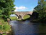 Upload another image
See more images |
| Keir House, Keir Home Farm | | | | 56°10′14″N3°58′42″W / 56.170461°N 3.978276°W / 56.170461; -3.978276 (Keir House, Keir Home Farm) | Category A | 3918 | |
| Sheriffmuir Inn | | | | 56°11′50″N3°53′31″W / 56.197261°N 3.892017°W / 56.197261; -3.892017 (Sheriffmuir Inn) | Category C(S) | 3925 | |
| Kippenross House | | | | 56°10′37″N3°57′32″W / 56.176971°N 3.958844°W / 56.176971; -3.958844 (Kippenross House) | Category B | 3928 | |
| Railway Viaduct At Old Mill Of Keir, S. Of Kippenross House Tunnelmouth To N | | | | 56°10′31″N3°57′35″W / 56.175311°N 3.959838°W / 56.175311; -3.959838 (Railway Viaduct At Old Mill Of Keir, S. Of Kippenross House Tunnelmouth To N) | Category C(S) | 3934 | |
| Keir House, Ice House | | | | 56°10′07″N3°58′51″W / 56.168649°N 3.980857°W / 56.168649; -3.980857 (Keir House, Ice House) | Category B | 3943 | |
| Arnhall Castle | | | | 56°09′51″N3°59′33″W / 56.164069°N 3.992426°W / 56.164069; -3.992426 (Arnhall Castle) | Category B | 171 | |
| Cromlix House Including Game Larder, Ancillary Building, Gatepiers And Garden Boundary Walls | | | | 56°13′54″N3°57′59″W / 56.231658°N 3.966507°W / 56.231658; -3.966507 (Cromlix House Including Game Larder, Ancillary Building, Gatepiers And Garden Boundary Walls) | Category C(S) | 50619 | |
| Keir, Terracing And Column To East | | | | 56°10′00″N3°58′53″W / 56.166637°N 3.981398°W / 56.166637; -3.981398 (Keir, Terracing And Column To East) | Category C(S) | 3975 | |
| Memorial Chapel, Dunblane | | | | 56°12′00″N3°57′10″W / 56.200029°N 3.952684°W / 56.200029; -3.952684 (Memorial Chapel, Dunblane) | Category A | 3987 | |
| Infirmary, Dunblane | | | | 56°11′59″N3°57′06″W / 56.199738°N 3.951735°W / 56.199738; -3.951735 (Infirmary, Dunblane) | Category C(S) | 3988 | |
| Gateside, Octagon | | | | 56°12′55″N3°56′14″W / 56.215379°N 3.937193°W / 56.215379; -3.937193 (Gateside, Octagon) | Category C(S) | 3995 | |
| Lecropt School | | | | 56°09′28″N3°57′27″W / 56.157662°N 3.957571°W / 56.157662; -3.957571 (Lecropt School) | Category B | 3908 | |
| Kilbryde Castle | | | | 56°12′34″N4°00′26″W / 56.209344°N 4.007336°W / 56.209344; -4.007336 (Kilbryde Castle) | Category B | 3909 | |
| Keir, Tunnel And Terrace Over | | | | 56°10′01″N3°58′57″W / 56.166834°N 3.982535°W / 56.166834; -3.982535 (Keir, Tunnel And Terrace Over) | Category B | 3970 | |
| Queen Victoria School, Dunblane, Wall And Gates | | | | 56°12′07″N3°57′16″W / 56.201836°N 3.954324°W / 56.201836; -3.954324 (Queen Victoria School, Dunblane, Wall And Gates) | Category C(S) | 3990 | |
| Cromlix House, Sundial And Flanking Pair Of Gatepiers (Formerly Fireplace Jambs) | | | | 56°13′54″N3°57′59″W / 56.231658°N 3.966507°W / 56.231658; -3.966507 (Cromlix House, Sundial And Flanking Pair Of Gatepiers (Formerly Fireplace Jambs)) | Category A | 3997 |  Upload another image
|
| Kilbryde Stable Block | | | | 56°12′36″N4°00′30″W / 56.210108°N 4.008424°W / 56.210108; -4.008424 (Kilbryde Stable Block) | Category B | 3910 | |
| Keir House, Water House | | | | 56°10′09″N3°58′57″W / 56.169071°N 3.982602°W / 56.169071; -3.982602 (Keir House, Water House) | Category C(S) | 3915 | |
| Keir, South Lodge | | | | 56°10′07″N3°58′24″W / 56.168716°N 3.973306°W / 56.168716; -3.973306 (Keir, South Lodge) | Category A | 3921 | |
| Keir House, Archway South Of, Carrying West Drive | | | | 56°09′58″N3°58′54″W / 56.166028°N 3.981801°W / 56.166028; -3.981801 (Keir House, Archway South Of, Carrying West Drive) | Category B | 3940 | |
| Keir House Avenue Bridge William Stirling Cenotaph | | | | 56°10′02″N3°58′54″W / 56.16718°N 3.981716°W / 56.16718; -3.981716 (Keir House Avenue Bridge William Stirling Cenotaph) | Category B | 3974 | |
| Keir, Encircling Wall Of Eastern Portion Of Gardens Running From Keir House To Stud House A) Salve Gateway B) Gateway & Stairs On N. Lodge Drive C) Swan Gateway, Stud House | | | | 56°10′04″N3°58′27″W / 56.167822°N 3.974146°W / 56.167822; -3.974146 (Keir, Encircling Wall Of Eastern Portion Of Gardens Running From Keir House To Stud House A) Salve Gateway B) Gateway & Stairs On N. Lodge Drive C) Swan Gateway, Stud House) | Category B | 3976 | |
| Ryland (Formerly Kippendavie) Lodge, Dunblane | | | | 56°11′50″N3°56′46″W / 56.197336°N 3.946245°W / 56.197336; -3.946245 (Ryland (Formerly Kippendavie) Lodge, Dunblane) | Category C(S) | 3985 | |
| Keir House, Lodge | | | | 56°10′17″N3°58′42″W / 56.171513°N 3.97825°W / 56.171513; -3.97825 (Keir House, Lodge) | Category B | 3919 | |
| Keir House North Lodge | | | | 56°10′05″N3°58′10″W / 56.168067°N 3.969536°W / 56.168067; -3.969536 (Keir House North Lodge) | Category C(S) | 3920 | |
| Railway Viaduct At Old Mill Of Keir, S. Of Kippenross House | | | | 56°10′30″N3°57′35″W / 56.174999°N 3.959694°W / 56.174999; -3.959694 (Railway Viaduct At Old Mill Of Keir, S. Of Kippenross House) | Category B | 3933 | |
| Lecropt Church Cottage | | | | 56°09′29″N3°57′51″W / 56.158105°N 3.964163°W / 56.158105; -3.964163 (Lecropt Church Cottage) | Category C(S) | 47649 | |
| Keir House Walled Garden Screen Wall And Gateway To N.W | | | | 56°10′05″N3°59′04″W / 56.167974°N 3.984318°W / 56.167974; -3.984318 (Keir House Walled Garden Screen Wall And Gateway To N.W) | Category B | 3978 | |
| Keir House Water Garden | | | | 56°09′58″N3°59′17″W / 56.166208°N 3.987963°W / 56.166208; -3.987963 (Keir House Water Garden) | Category C(S) | 3979 | |
| Headmaster's House, Dunblane | | | | 56°12′07″N3°57′13″W / 56.20184°N 3.953518°W / 56.20184; -3.953518 (Headmaster's House, Dunblane) | Category C(S) | 3989 | |
| Glassingal House, South Lodge | | | | 56°12′52″N3°56′55″W / 56.214337°N 3.948606°W / 56.214337; -3.948606 (Glassingal House, South Lodge) | Category B | 3991 | |
| Wester Cambushinnie, Cottar House And Bothy | | | | 56°14′12″N3°57′10″W / 56.236773°N 3.952763°W / 56.236773; -3.952763 (Wester Cambushinnie, Cottar House And Bothy) | Category C(S) | 3999 | |
| Keir House, Gardens House | | | | 56°09′59″N3°58′59″W / 56.166414°N 3.982932°W / 56.166414; -3.982932 (Keir House, Gardens House) | Category C(S) | 3916 | |
| Keir, Bairnsburn | | | | 56°09′40″N3°58′27″W / 56.161001°N 3.974167°W / 56.161001; -3.974167 (Keir, Bairnsburn) | Category C(S) | 3923 | |
| Keir, Old Walled Garden West Of (Camey Bank) | | | | 56°09′38″N3°59′11″W / 56.160672°N 3.986276°W / 56.160672; -3.986276 (Keir, Old Walled Garden West Of (Camey Bank)) | Category C(S) | 3924 | |
| Sheriffmuir, Macrae Memorial | | | | 56°11′43″N3°54′37″W / 56.195238°N 3.910211°W / 56.195238; -3.910211 (Sheriffmuir, Macrae Memorial) | Category B | 3926 | |
| Kippenross Sundial | | | | 56°10′36″N3°57′31″W / 56.17674°N 3.958719°W / 56.17674; -3.958719 (Kippenross Sundial) | Category C(S) | 3929 | |
| Kippenross Walled Garden | | | | 56°10′33″N3°57′45″W / 56.175701°N 3.962452°W / 56.175701; -3.962452 (Kippenross Walled Garden) | Category B | 3930 | |
| Keir House | | | | 56°09′58″N3°58′58″W / 56.165994°N 3.98283°W / 56.165994; -3.98283 (Keir House) | Category A | 3935 | 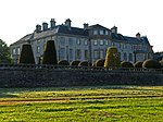 Upload another image
|


