Lake of Menteith

Last updated

Lake of Menteith
Lake of Menteith looking towards Port of Monteith.jpg
Looking towards Port of Menteith
Stirling UK relief location map.jpg
Red pog.svg
Lake of Menteith
Coordinates 56°10′28″N4°17′32″W / 56.1744°N 4.2921°W / 56.1744; -4.2921
Type freshwater loch
Primary outflows River Forth
Max. length2.4 km (1.5 mi) [1]
Max. width1.6 km (1 mi) [1]
Surface area252 ha (620 acres) [2]
Average depth6.02 m (19.75 ft) [1]
Max. depth23 m (77 ft) [1]
Shore length19.7 km (6.0 mi) [2]
Surface elevation18 m (59 ft) [2]
Islands Inchmahome, Dog Isle, Inch Talla
1 Shore length is not a well-defined measure.

Lake of Menteith, also known as Loch Inchmahome (Scottish Gaelic: Loch Innis Mo Cholmaig), is a loch in Scotland located on the Carse of Stirling (the flood plain of the upper reaches of the rivers Forth and Teith, upstream from Stirling). [1] [2]

Contents

Name

Until the early 19th century, the loch was more commonly known by the Scottish name, “Loch of Menteith”, although, on the 1654 map, Blaeu Atlas of Scotland, it is identified as “Loch Inche Mahumo”. The only settlement of any size on the Loch of Menteith is the Port of Menteith. [3]

Geography

There are a number of small islands in the loch. On the largest, Inchmahome, is Inchmahome Priory, an ancient monastery. The priory served as refuge to Mary, Queen of Scots, in 1547. She was only four years old at the time and stayed for three weeks after the disastrous Battle of Pinkie Cleugh in September of that year. The loch is not particularly deep and can freeze over completely in exceptionally cold winters. If the ice becomes thick enough, at least 7 inches (18 cm) [4] , an outdoor curling tournament called the Bonspiel (or the Grand Match) is held on the loch. The event can attract thousands of curlers even though it is held very infrequently. The last Grand Match was held in 1979. The Bonspiel that had been planned for 2010 was abandoned on health and safety grounds. [5]

Curling on Lake of Menteith Curling on Lake of Menteith - geograph.org.uk - 1756810.jpg
Curling on Lake of Menteith

The Lake of Menteith is often thought of as the only body of water in Scotland that is referred to as a lake. Actually, there are several others, some of which have been artificially created: Pressmennan Lake, East Lothian; the Lake of the Hirsel, Berwickshire; Lake Louise (within the grounds of Skibo Castle, Sutherland); Raith Lake, Fife; [6] Upper Lake and Kelly Lake (both near Haddo House, Aberdeenshire); Pitfour Lake and Cally Lake (near Gatehouse of Fleet, Kirkcudbrightshire). There is also a sea bay near Kirkcudbright known as Manxman's Lake. Nearly all other major bodies of water in Scotland are known as lochs.

The unusual name “Lake of Menteith” is believed to be due to the UK Government's Ordnance Survey in 1838 who mapped the area for the first time, and identified it as a “lake” because it was referred to as a lake in literature that was prominent at the time.[ citation needed ]

Malling Roman Fort

There was a Roman fort at a site associated with the Gask Ridge, to the west of the lake. The Romans may have referred to the site as "Lindon". [7] It was discovered by David Wilson [8] and Kenneth St Joseph in 1968 when they were conducting an aerial survey of Flanders Moss. [9] After taking aerial photographs, they assessed the site by measuring resistance and magnetic susceptibility at ground level. [10]

Forts and Fortlets associated with the Gask Ridge from south to north Balmuildy, Cadder, Castlecary, Mumrills, Camelon, Drumquhassle, Malling, Doune, Glenbank, Bochastle, Ardoch, Sheilhill, Strageath, Dalginross, Midgate, Bertha, Fendoch, Cargill, Cardean, Inchtuthil, Inverquharity, Stracathro Gask Ridge.jpg
Forts and Fortlets associated with the Gask Ridge from south to north Balmuildy, Cadder, Castlecary, Mumrills, Camelon, Drumquhassle, Malling, Doune, Glenbank , Bochastle, Ardoch, Sheilhill , Strageath, Dalginross, Midgate , Bertha, Fendoch, Cargill, Cardean, Inchtuthil , Inverquharity , Stracathro

In 2020, the lake was featured in the BBC programme Springwatch , presented by wildlife photographer Gordon Buchanan. [13]

Related Research Articles

<span class="mw-page-title-main">Aberfoyle, Stirling</span> Human settlement in Scotland

Aberfoyle is a village in the historic county and registration county of Perthshire and the council area of Stirling, Scotland. The settlement lies 27 miles northwest of Glasgow.

<span class="mw-page-title-main">Loch</span> Scottish Gaelic word for a lake or sea inlet

Loch is a word meaning "lake" or "sea inlet" in Scottish and Irish Gaelic, subsequently borrowed into English. In Irish contexts, it often appears in the anglicized form "lough".

<span class="mw-page-title-main">Menteith</span>

<span class="mw-page-title-main">Stirling (council area)</span> Council area of Scotland

The Stirling council area is one of the 32 council areas of Scotland, and has a population of about 93,470. It was created in 1975 as a lower-tier district within the Central region. The district covered parts of the historic counties of Stirlingshire and Perthshire, which were abolished for local government purposes. In 1996 the Central region was abolished and Stirling Council took over all local government functions within the area.

<span class="mw-page-title-main">Loch Leven (Kinross)</span> Freshwater loch

Loch Leven is a fresh water loch located immediately to the east of the burgh of Kinross in Perth and Kinross council area, central Scotland. Roughly triangular, the loch is about 6 km (3.7 mi) at its longest. Prior to the canalisation of the River Leven, and the partial draining of the loch in 1826–36, Loch Leven was considerably larger. The drop in water level by 1.4 m reduced the loch to 75% of its former size, and exposed several small islands, as well as greatly increasing the size of the existing ones.

<span class="mw-page-title-main">Gask Ridge</span> Roman fortifications in Scotland

The Gask Ridge is the modern name given to an early series of fortifications, built by the Romans in Scotland, close to the Highland Line. Modern excavation and interpretation has been pioneered by the Roman Gask Project, with Birgitta Hoffmann and David Woolliscroft. The ridge fortifications: forts, fortlets and watchtowers were only in operation for a few years, probably less than ten.

<span class="mw-page-title-main">Trossachs</span> Area of wooded hills and lochs in the southern part of the Scottish Highlands

The Trossachs generally refers to an area of wooded glens, braes, and lochs lying to the east of Ben Lomond in the Stirling council area of Scotland. The name is taken from that of a small woodland glen that lies at the centre of the area, but is now generally applied to the wider region.

A bonspiel is a curling tournament, consisting of several games, often held on a weekend. Until the 20th century most bonspiels were held outdoors, on a frozen freshwater loch. Today almost all bonspiels are held indoors on specially prepared artificial ice.

<span class="mw-page-title-main">Inchmahome Priory</span>

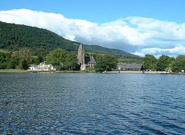
Inchmahome Priory is situated on Inchmahome, the largest of three islands in the centre of the Lake of Menteith, close to Aberfoyle, Scotland.

<span class="mw-page-title-main">Grand Match</span> Scottish curling tournament

The Grand Match, also called The Bonspiel, is an outdoor curling tournament, or bonspiel, held most recently on the Lake of Menteith in Stirling, Scotland, when the weather is cold enough. Traditionally it is a match between the north and south of Scotland.

<span class="mw-page-title-main">Inchmahome</span>

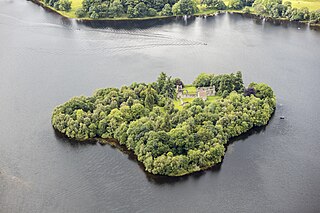
Inchmahome, an anglicisation of Innis Mo Cholmaig, is the largest of three islands in the Lake of Menteith, in Stirlingshire.

<span class="mw-page-title-main">Arnprior, Stirling</span> Human settlement in Scotland

Arnprior is a hamlet in the Stirling council area of Scotland on the A811 about 12 miles west of Stirling and is one of the smallest community council districts in the region. The hamlet is next to the Flanders Moss National Nature Reserve and close to the east boundary of the Loch Lomond and Trossachs National Park, which includes the Lake of Menteith.

<span class="mw-page-title-main">Findo Gask</span> Village in Scotland

Findo Gask is a small village in Perth and Kinross in Scotland, just off the main A9 road. It is in Strathearn.

<span class="mw-page-title-main">Port of Menteith</span> Village in Scotland

Port of Menteith is a village and civil parish in the Stirling district of Scotland, the only significant settlement on the Lake of Menteith. It was established as a burgh of barony, then named simply Port, in 1457 by King James III of Scotland. It lies in the historic county and Registration County of Perthshire.

<span class="mw-page-title-main">Glen Finglas</span>

<span class="mw-page-title-main">Drumquhassle</span>

Drumquhassle was a Roman fort associated with the Gask Ridge in Scotland. It was found from aerial photography in the late 1970s. The name selected for the fort deliberately made it hard for English born readers to pronounce. The fort was from the Flavian period; it was built and briefly occupied by during the administration of Sallustius Lucullus. It is known as a "Glen-blocker" fort and is located within sight of Loch Lomond.

<span class="mw-page-title-main">Glenbank</span>

Glenbank was the site of a Roman fortlet associated with the Gask Ridge in Scotland. It was discovered from aerial photography by G. S. Maxwell in 1983. It was confirmed by geophysics and excavations which were carried out in 1984 and 1999. It is beside the Roman road that linked the forts at Ardoch and Doune. It is currently the most southerly of the known Gask fortifications. It was probably built around 70-80 AD. Several other Gask installations have been identified running north to Bertha.

<span class="mw-page-title-main">Carsbreck railway station</span> Railway station in Blackford, Scotland

Carsbreck railway station was a private station opened on the Scottish Central Railway near Carsebreck Loch, the Royal Caledonian Curling pond, between Stirling and Perth for the use of the curlers belonging to the Royal Caledonian Curling Club. It was first named by the Scottish Central Railway as 'Royal Curling Club Station, a host of later names being Caledonian Curling Society's Platform, Curling Pond Halt, Royal Curling Club Platform, Royal Curling Club Station, Netherton Halt and finally as Carsbreck Station. It is unclear how many of these were official names. The site lay in the parish of Ardoch, Perth and Kinross with the villages of Braco, Greenloaning and Blackford nearby. The Scottish Central Railway line had been opened in 1848.

References

  1. 1 2 3 4 5 John, Murray; Lawrence, Pullar (1910). Bathymetrical Survey of the Fresh-Water Lochs of Scotland, 1897-1909 Lochs of the Forth Basin Volume II - Lake of Menteith. National Library of Scotland: National Challenger Officer. p. 16. Retrieved 12 May 2018.PD-icon.svg This article incorporates text from this source, which is in the public domain .
  2. 1 2 3 4 "Lake of Menteith". British Lakes. Retrieved 12 May 2018.
  3. "Why is the Loch of Menteith a loch and not a Lake?". The Scots Magazine. D.C. Thomson. 74: 374. 1960.
  4. "Curlers prepare for 'Grand Match'". BBC News. 5 January 2010. Retrieved 5 January 2010.
  5. "Grand Match off over safety fears". BBC News. 8 January 2010. Retrieved 9 January 2010.
  6. "Raith Lake Trout Fishery". Raithlake.com. Retrieved 6 November 2012.
  7. "Gazetteer". Roman Gask Project. Retrieved 30 June 2018.
  8. "AARG Conversation N o 3: David Wilson and Rog Palmer: 29 July 1998" (PDF). AARGnews 17. September 1998. Retrieved 30 June 2018.
  9. "Menteith, Malling Glen Fort and Marching Camps". Roman Britain. Retrieved 30 June 2018.
  10. "Malling". Canmore. Historic Environment Scotland. Retrieved 30 June 2018.
  11. "Gask Ridge". Scribble Maps. Retrieved 9 June 2018.
  12. "Gask Ridge Map". HeritageDaily. Retrieved 9 June 2018.
  13. "Springwatch:Episode 8". Springwatch. Retrieved 7 June 2020.