
Loch is a word meaning "lake" or "sea inlet" in Scottish and Irish Gaelic, subsequently borrowed into English. In Irish contexts, it often appears in the anglicized form "lough".

East Lothian is one of the 32 council areas of Scotland, as well as a historic county, registration county and lieutenancy area. The county was called Haddingtonshire until 1921.

Lake of Menteith, also known as Loch Inchmahome, is a loch in Scotland located on the Carse of Stirling.

The Trossachs generally refers to an area of wooded glens, braes, and lochs lying to the east of Ben Lomond in the Stirling council area of Scotland. The name is taken from that of a small woodland glen that lies at the centre of the area, but is now generally applied to the wider region.

Eye Water is a river in the Scottish Borders, it flows in a general southeasterly direction from its source in the Lammermuir Hills to its estuary at Eyemouth on the east coast of Scotland, having a length of approximately 35 kilometres (22 mi).

The Lake of the Hirsel or Hirsel Lake is an artificial body of water and Site of Special Scientific Interest near Coldstream in Berwickshire in Scotland. It is set in the grounds of The Hirsel, home of the Home family and of the late Alec Douglas-Home, former British prime minister.
Sir Robert Lauder of the Bass was a Scottish knight, armiger, and Governor of the Castle at Berwick-upon-Tweed. He was also a member of the old Scottish Parliament. The Lauders held the feudal barony of The Bass, East Lothian, Edrington Castle and lands in the parish of Mordington, Berwickshire, Tyninghame in Haddingtonshire, and numerous other estates and properties elsewhere in Scotland.

Glen Affric is a glen south-west of the village of Cannich in the Highland region of Scotland, some 15 miles west of Loch Ness. The River Affric runs along its length, passing through Loch Affric and Loch Beinn a' Mheadhoin. A minor public road reaches as far as the end of Loch Beinn a' Mheadhoin, but beyond that point only rough tracks and footpaths continue along the glen.

East Saltoun and West Saltoun are separate villages in East Lothian, Scotland, about 5 miles south-west of Haddington and 20 miles east of Edinburgh.

Whiteadder Water is a river in East Lothian and Berwickshire, Scotland. It also flows for a very short distance through Northumberland before joining the River Tweed. In common with the headwaters of the Biel Water it rises on the low hillside of Clints Dod in the Lammermuir Hills, just ESE of Whitecastle Hillfort and 3 km (1.9 mi) south-east of the village of Garvald.

Stenton is a parish and village in East Lothian, Scotland. It is bounded on the north by parts of the parishes of Prestonkirk and Dunbar, on the east by Spott and on the west by Whittingehame. The name is said to be of Saxon derivation. The village has a number of houses, a school, and a church.
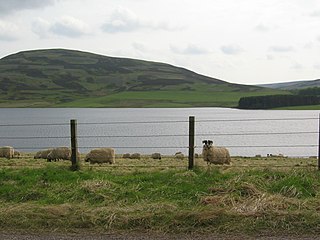
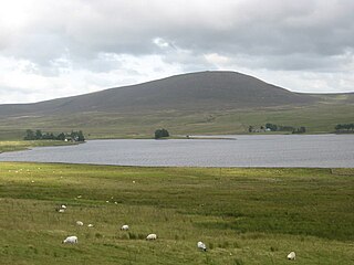
Whiteadder Reservoir is a reservoir in East Lothian, Scotland, UK, in the Lammermuir Hills, 11 miles (18 km) north west of Duns in the Scottish Borders, and five miles (8 km) south east of Garvald. It was created to provide additional water facilities for East Lothian.

Smeaton is a village and country estate in East Lothian, Scotland. It is off the B1047, near East Linton, and very close to Prestonkirk Parish Church as well as the National Trust for Scotland properties Preston Mill and Phantassie Doocot.
Harperrig Reservoir is a reservoir in West Lothian, Scotland, to the north of the Pentland Hills, four miles (6.4 km) south of Mid Calder. The Water of Leith flows through it, and nearby are Harlaw Reservoir and Threipmuir Reservoir. It has been proposed that the reservoir be designated as a local nature reserve to be managed by West Lothian Council.

Glen Finglas is a glen in the Trossachs, in the Stirling council area of Scotland. It is an area of forest in Highlands of the former county of Perthshire, north of Brig o' Turk, close to Callander in Menteith. To the west is Loch Katrine.

Rubers Law is a prominent, conical hill in the Scottish Borders area of south-east Scotland. It stands on the south bank of the River Teviot, between the towns of Hawick and Jedburgh, and south of the village of Denholm. The hill is on the border between the historic parishes of Cavers and Hobkirk, and until 1975 it stood within the historic county of Roxburghshire.

Cranshaws is a village on the B6355 road, near Duns, in the Scottish Borders area of Scotland, in the former Berwickshire.

Balnaguard Glen is a Scottish Wildlife Trust reserve near the village of Balnaguard, Perthshire. It is notable for its juniper woodland, which is amongst the largest in Perthshire.

Hopes Reservoir is a small reservoir in East Lothian, Scotland, in the Lammermuir Hills. It is located in the parish of Yester, 6 km (3.7 mi) south of the village of Gifford and 1 km (0.62 mi) east of the hill Lammer Law. It is fed by the Hopes Water which flows northwards from the reservoir to join the Coulston Water, a tributary of the River Tyne, 1.5 km (0.93 mi) southeast of Gifford. The reservoir was opened in 1933 and the embankment that dams the Hopes Water was created using the rubble of Edinburgh's Calton Jail, which was demolished in 1930 to make way for St Andrews House. The reservoir is a drinking water supply reservoir operated by Scottish Water.

