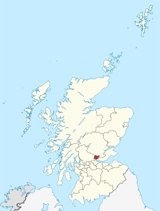
Clackmannanshire, or the County of Clackmannan, is a historic county, council area, registration county and lieutenancy area in Scotland, bordering the council areas of Stirling, Fife, and Perth and Kinross. In terms of historic counties it borders Perthshire, Stirlingshire and Fife.

The Firth of Forth is the estuary, or firth, of several Scottish rivers including the River Forth. It meets the North Sea with Fife to its north and Lothian to its south.

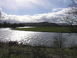
Alloa is a town in Clackmannanshire in the Central Lowlands of Scotland. It is on the north bank of the Forth at the spot where some say it ceases to be the River Forth and becomes the Firth of Forth. Alloa is south of the Ochil Hills on the western Fife peninsula, 6.0 miles (9.7 km) east of Stirling and 13.0 miles (20.9 km) west of Dunfermline; by water Alloa is 25 miles (40 km) from Granton.

Stirlingshire or the County of Stirling is a historic county and registration county of Scotland. Its county town is Stirling.
The Stirling council area is one of the 32 council areas of Scotland, and has an estimated population of 92,530 (2022). It was created in 1975 as a lower-tier district within the Central region. The district covered parts of the historic counties of Stirlingshire and Perthshire, which were abolished for local government purposes. In 1996 the Central region was abolished and Stirling Council took over all local government functions within the area.
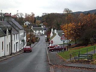
Gargunnock is a small village in the Stirling council area with an active community trust, seven miles west of Stirling, in Scotland. The census population was 912. It is situated on the south edge of the Carse of Stirling, at the foot of the Gargunnock Hills, part of the Campsie Fells.
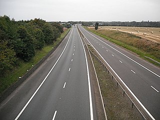
The M876 motorway is a motorway in Scotland. The motorway runs from Denny to Airth in the Falkirk council area, forming an approach road to the Kincardine Bridge. It was opened in 1980.

The Kincardine Bridge is a road bridge crossing the Firth of Forth from Falkirk council area to Kincardine, Fife, Scotland.

Clackmannan, is a small town and civil parish set in the Central Lowlands of Scotland. Situated within the Forth Valley, Clackmannan is 1.8 miles (2.9 km) south-east of Alloa and 3.2 miles (5.1 km) south of Tillicoultry. The town is within the county of Clackmannanshire, of which it was formerly the county town, until Alloa overtook it in size and importance.
Kincardine or Kincardine-on-Forth is a town on the north shore of the Firth of Forth, in Fife, Scotland. The town was given the status of a burgh of barony in 1663. It was at one time a reasonably prosperous minor port. The townscape retains many good examples of Scottish vernacular buildings from the 17th, 18th and early 19th centuries, although it was greatly altered during the construction of Kincardine Bridge in 1932–1936. It is in the civil parish of Tulliallan.
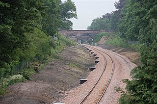
The Stirling–Alloa–Kincardine rail link is a completed railway project to re-open 21 kilometres (13 mi) of railway between Stirling, Alloa and Kincardine in Scotland. The route opened to rail traffic in March 2008.

Alloa railway station is a railway station in the town of Alloa, Clackmannanshire, Scotland.

The Stirling and Dunfermline Railway was a railway in Scotland connecting Stirling and Dunfermline. It was planned by the Edinburgh and Glasgow Railway to get access to the mineral deposits on the line of route, but also as a tactical measure to keep the rival Caledonian Railway out of Fife.
The Kincardine Line is a railway in Clackmannanshire and Fife, Scotland. It was originally built to serve settlements along the north shore of the Firth of Forth, between Alloa and Dunfermline.
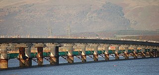
The Clackmannanshire Bridge is a road bridge over the Firth of Forth in Scotland which opened to traffic on 19 November 2008. Prior to 1 October 2008 the bridge was referred to as the upper Forth crossing while the name was chosen.

National Cycle Network (NCN) Route 76 is a Sustrans National Route that runs from Berwick-upon-Tweed to Kirkcaldy. The route is 168 miles (270 km) in length and is fully open and signed in both directions. Between Dunbar and Kirkcaldy the route is known as the Round the Forth.

The Queensferry Crossing is a road bridge in Scotland. It was built alongside the existing Forth Road Bridge and the Forth Bridge. It carries the M90 motorway across the Firth of Forth between Edinburgh, at South Queensferry, and Fife, at North Queensferry.

Cambus is a village near Alloa, Clackmannanshire. It is located to the south of Tullibody, to the northwest of Alloa, and about 4 miles east of Stirling, across the river. It lies on the River Devon, near its confluence with the River Forth.
The Firth of Forth was historically crossed by ferry until the opening of the Forth Road Bridge in 1964.