Tullibody Inch

Last updated

Tullibody Inch
Meaning of nameTullibody island
Cowie and the River Forth from the air (geograph 5222078).jpg
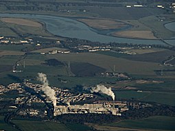
Tullibody Inch from the air (towards top right)
Location
Scotland relief location map.jpg
Red pog.svg
Tullibody Inch
Tullibody Inch shown within Scotland
OS grid reference NS862925
Coordinates 56°06′40″N3°49′49″W / 56.11121°N 3.83015°W / 56.11121; -3.83015 Coordinates: 56°06′40″N3°49′49″W / 56.11121°N 3.83015°W / 56.11121; -3.83015
Physical geography
Island group Forth
Areac.6 ha [1]
Highest elevation<5 metres (16 ft)
Administration
Sovereign state United Kingdom
Country Scotland
Council area Clackmannanshire
Lymphad3.svg
The River Forth at Alloa showing Alloa Inch and Tullibody Inch (at right) The Forth Valley near Alloa - geograph.org.uk - 723980.jpg
The River Forth at Alloa showing Alloa Inch and Tullibody Inch (at right)

Tullibody Inch is an islet in the estuarine waters of the River Forth. [1] It takes its name from the nearby town of Tullibody, "inch" being from the Scottish Gaelic innis meaning "island" or "meadow". [2]

The island used to be farmland but has become flooded due to mining subsidence. It is now part of the Firth of Forth SSSI, which also includes nearby Alloa Inch and the John Muir Country Park. [3] The Scottish Wildlife Trust owns and manages the island as a nature reserve. [4]

Wildlife

The area is important for its extensive reed beds and for nationally important numbers of wintering wildfowl and wading birds. The inner Forth hosts populations of common shelduck, red knot, common redshank, great crested grebe, Eurasian teal and common goldeneye. [5] A marsh harrier, of which only a handful of pairs nest in Scotland, was seen on the island in September 2006. [6]

Related Research Articles

Holkham National Nature Reserve Nature reserve in the United Kingdom

Holkham National Nature Reserve is England's largest national nature reserve (NNR). It is on the Norfolk coast between Burnham Overy Staithe and Blakeney, and is managed by Natural England with the cooperation of the Holkham Estate. Its 3,900 hectares comprise a wide range of habitats, including grazing marsh, woodland, salt marsh, sand dunes and foreshore. The reserve is part of the North Norfolk Coast Site of Special Scientific Interest, and the larger area is additionally protected through Natura 2000, Special Protection Area (SPA) and Ramsar listings, and is part of both an Area of Outstanding Natural Beauty (AONB) and a World Biosphere Reserve. Holkham NNR is important for its wintering wildfowl, especially pink-footed geese, Eurasian wigeon and brant geese, but it also has breeding waders, and attracts many migrating birds in autumn. A number of scarce invertebrates and plants can be found in the dunes, and the reserve is one of the only two sites in the UK to have an antlion colony.

NatureScot Scottish government agency for natural heritage conservation

NatureScot, which was formerly known as Scottish Natural Heritage, is the public body responsible for Scotland's natural heritage, especially its natural, genetic and scenic diversity. It advises the Scottish Government and acts as a government agent in the delivery of conservation designations, i.e. national nature reserves, local nature reserves, national parks, Sites of Special Scientific Interest (SSSIs), Special Areas of Conservation, Special Protection Areas and the national scenic areas. The protected areas in Scotland account for 20% of the total area, SSSIs alone 13%. NatureScot receives annual funding from the Government in the form of Grant in Aid to deliver Government priorities for the natural heritage.

North Queensferry Human settlement in Scotland

North Queensferry is a village in Fife, Scotland, situated on the Firth of Forth where the Forth Bridge, the Forth Road Bridge, and the Queensferry Crossing all meet the Fife coast, some 10 miles from the centre of Edinburgh. According to the 2011 census, the village has a population of 1,076. It is the southernmost settlement in Fife.

The Swale

The Swale is a tidal channel of the Thames estuary that separates the Isle of Sheppey from the rest of Kent. On its banks is a 6,509.4-hectare (16,085-acre) biological Site of Special Scientific Interest which stretches from Sittingbourne to Whitstable in Kent. It is also a Ramsar internationally important wetland site and a Special Protection Area under the European Union Directive on the Conservation of Wild Birds. Parts of it are a Nature Conservation Review site, Grade I, National Nature Reserves, a Kent Wildlife Trust nature reserve and a Local Nature Reserve.

Eyebroughy

Eyebroughy is a small, rocky islet in the Firth of Forth, 200 m off East Lothian, Scotland.

Havergate Island

Havergate Island is the only island in the county of Suffolk, England. It is found at the confluence of the River Ore and the Butley River near the village of Orford. It is a marshy nature reserve run by the Royal Society for the Protection of Birds (RSPB) and is known for its population of pied avocets and terns. It is part of the ecologically important Alde-Ore Estuary and has protected conservation status as part of a national nature reserve, SSSI, SAC, SPA, Ramsar Site and is also a part of the Suffolk Coast and Heaths AONB.

Fauna of Scotland Animals living in Scotland

The fauna of Scotland is generally typical of the northwest European part of the Palearctic realm, although several of the country's larger mammals were hunted to extinction in historic times and human activity has also led to various species of wildlife being introduced. Scotland's diverse temperate environments support 62 species of wild mammals, including a population of wild cats, important numbers of grey and harbour seals and the most northerly colony of bottlenose dolphins in the world.

Islands of the Forth Group of islands in the Firth of Forth, Scotland

The Islands of the Forth are a group of small islands located in the Firth of Forth and in the estuary of the River Forth on the east coast of Scotland. Most of the group lie in the open waters of the firth, between the Lothians and Fife, with the majority to the east of the city of Edinburgh. Two islands lie further west in the river estuary.

Alloa Inch

Inch or Alloa Inch is an island in the tidal reaches of the River Forth near Alloa, just before the river opens out into the Firth of Forth.

Levenhall Links

Levenhall Links is a coastal, industrial, and recreational area at Musselburgh, East Lothian, Scotland, UK; it is adjacent to Musselburgh Racecourse, Morrison's Haven and Prestongrange Industrial Heritage Museum. Its western boundary is the River Esk and its eastern is at Morrison's Haven.

Flora and fauna of the Outer Hebrides

The flora and fauna of the Outer Hebrides in north west Scotland comprises a unique and diverse ecosystem. A long archipelago, set on the eastern shores of the Atlantic Ocean, it attracts a wide variety of seabirds, and thanks to the Gulf Stream a climate more mild than might be expected at this latitude. Because it is on the Gulf Stream, it also occasionally gets exotic visitors.

North Warren RSPB reserve

North Warren RSPB reserve is a nature reserve run by the Royal Society for the Protection of Birds (RSPB) in Suffolk, England. It lies on the Suffolk coast on the north edge of the town of Aldeburgh and to the south of Thorpeness and includes the Aldringham Walks area of heathland to the north. It is within the Suffolk Coast and Heaths Area of Outstanding Natural Beauty (AONB) and the Suffolk Heritage Coast area. Noted for its populations of Eurasian bittern, European nightjar and other bird species, it covers a range of coastal habitats and is protected with SSSI, SPA conservation status.

Nature reserves in the North Norfolk Coast Site of Special Scientific Interest

The North Norfolk Coast Site of Special Scientific Interest (SSSI) is an internationally important protected area in Norfolk, England. The SSSI is a long, narrow strip of coastal land that starts between Old Hunstanton and Holme-next-the-Sea, and runs east for about 43 km (27 mi) to Kelling. The southern boundary runs roughly west to east except where it detours around towns and villages, and never crosses the A149 coast road. It has an area of 7,700 ha (19,027 acres), and is additionally protected through Natura 2000, Special Protection Area (SPA) and Ramsar listings; it is also part of the Norfolk Coast Area of Outstanding Natural Beauty (AONB). Scolt Head Island and the coast from the Holkham National Nature Reserve to Salthouse are a Biosphere Reserve.

North Norfolk Coast Site of Special Scientific Interest Area of European importance for wildlife in Norfolk, England

The North Norfolk Coast Site of Special Scientific Interest (SSSI) is an area of European importance for wildlife in Norfolk, England. It comprises 7,700 ha (19,027 acres) of the county's north coast from just west of Holme-next-the-Sea to Kelling, and is additionally protected through Natura 2000, Special Protection Area (SPA) listings; it is also part of the Norfolk Coast Area of Outstanding Natural Beauty (AONB). The North Norfolk Coast is also designated as a wetland of international importance on the Ramsar list and most of it is a Biosphere Reserve.

Barnby Broad and Marshes

Barnby Broad and Marshes is a Site of Special Scientific Interest (SSSI) in the Waveney district of the English county of Suffolk. The site is 189.6 hectares in size. It is in the parishes of North Cove and Barnby, located between Beccles and Lowestoft in the north of the county. The site is bordered on its southern edge by the East Suffolk railway line and to the north by the River Waveney. It is a Special Area of Conservation, a Special Protection Area under the EC Birds Directive, and a Ramsar internationally important wetland site. There are two Suffolk Wildlife Trust nature reserves in the site, Castle Marshes and North Cove.

Cley Marshes Nature reserve on the North Sea coast of England

Cley Marshes is a 176-hectare (430-acre) nature reserve on the North Sea coast of England just outside the village of Cley next the Sea, Norfolk. A reserve since 1926, it is the oldest of the reserves belonging to the Norfolk Wildlife Trust (NWT), which is itself the oldest county Wildlife Trust in the United Kingdom. Cley Marshes protects an area of reed beds, freshwater marsh, pools and wet meadows and is part of the North Norfolk Coast Site of Special Scientific Interest (SSSI), Special Area of Conservation (SAC), Special Protection Area (SPA), and Ramsar Site due to the large numbers of birds it attracts.

Tentsmuir National Nature Reserve

Tentsmuir National Nature Reserve (NNR) is located southeast of Tayport in Fife, Scotland. The reserve is made up of three parts, encompassing Morton Lochs, Tentsmuir Point and Tayport Heath, and is managed by NatureScot. The different sections of Tentsmuir NNR were originally designated as separate national nature reserves at different times: the Morton Lochs section was designated in 1952; Tentsmuir Point in 1954; and Tayport Heath in 1988. While these discrete sections are distant from one another, they form part of the extensive dune system at Tentsmuir, and in 2003 SNH combined the three sites to form Tentsmuir National Nature Reserve. The adjoining Tentsmuir Forest is managed by Forestry and Land Scotland and covers most of the land between the three portions of the NNR.

The Inner Tay Estuary is the inner, western part of the Firth of Tay, from the Tay Railway Bridge in the east to the Queen's Bridge over the River Tay in Perth and the bridge in Bridge of Earn on the River Earn. It is one of the largest estuaries in eastern Scotland, and is up to 2.5 km wide. It consists primarily of intertidal sand and mud flats extending seaward to the main channel, most of which are on the northern shore. Landward of these are salt marsh and Phragmites reedbeds. The estuary contains two large islands: Mugdrum Island, opposite Newburgh; and Moncreiffe Island, immediately below Perth. The estuary's narrow form, and the large volume of freshwater from the Rivers Tay and Earn, restrict the influence of saltwater west of the Tayport narrows. Much of the tidal water is freshwater or mildly brackish.

Protected areas of Scotland Designated area for protection in Scotland

Many parts of Scotland are protected in accordance with a number of national and international designations because of their environmental, historical or cultural value. Protected areas can be divided according to the type of resource which each seeks to protect. NatureScot has various roles in the delivery of many environmental designations in Scotland, i.e. those aimed at protecting flora and fauna, scenic qualities and geological features. Historic Environment Scotland is responsible for designations that protect sites of historic and cultural importance. Some international designations, such as World Heritage Sites, can cover both categories of site.

Loch Spynie Loch in Moray, Scotland

Loch Spynie is a small loch located between the towns of Elgin and Lossiemouth in Moray, Scotland. Close to Spynie Palace, the ancient home of the bishops of Moray, it is an important wildlife habitat which is protected as a Ramsar Site.

References

  1. 1 2 Grid reference NS862924
  2. Iain Mac an Tàilleir. "Placenames" (PDF). Pàrlamaid na h-Alba. Retrieved 15 September 2010.
  3. Firth of Forth SSSI Management Statement. Scottish Natural Heritage. 2004.
  4. "Tullibody Inch". Gazetteer for Scotland. Retrieved 28 December 2007.
  5. "Firth of Forth SSSI Midas Reference 8163". Scottish Natural Heritage. Retrieved 15 September 2010.
  6. "Marsh harrier: Bird 21251". Highland Foundation for Wildlife. Archived from the original on 27 November 2010. Retrieved 16 September 2010.