
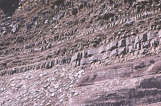
The Moine Thrust Belt or Moine Thrust Zone is a linear tectonic feature in the Scottish Highlands which runs from Loch Eriboll on the north coast 190 kilometres (120 mi) southwest to the Sleat peninsula on the Isle of Skye. The thrust belt consists of a series of thrust faults that branch off the Moine Thrust itself. Topographically, the belt marks a change from rugged, terraced mountains with steep sides sculptured from weathered igneous, sedimentary and metamorphic rocks in the west to an extensive landscape of rolling hills over a metamorphic rock base to the east. Mountains within the belt display complexly folded and faulted layers and the width of the main part of the zone varies up to ten kilometres, although it is significantly wider on Skye.

The Gascoyne Complex is a terrane of Proterozoic granite and metamorphic rock in the central-western part of Western Australia. The complex outcrops at the exposed western end of the Capricorn Orogen, a 1,000 km-long arcuate belt of folded, faulted and metamorphosed rocks between two Archean cratons; the Pilbara craton to the north and the Yilgarn craton to the south. The Gascoyne Complex is thought to record the collision of these two different Archean continental fragments during the Capricorn Orogeny at 1830–1780 Ma.
The Torridon Group is a series of Tonian arenaceous and argillaceous sedimentary rocks, which occur extensively in the Northwest Highlands of Scotland. These strata are particularly well exposed in the district of upper Loch Torridon, a circumstance which suggested the name Torridon Sandstone, first applied to these rocks by James Nicol. Stratigraphically, they lie unconformably on gneisses of the Lewisian complex and sandstones of the lithologically similar Mesoproterozoic Stoer Group and their outcrop extent is restricted to the Hebridean Terrane.
The Cadomian Orogeny was a tectonic event or series of events in the late Neoproterozoic, about 650–550 Ma, which probably included the formation of mountains. This occurred on the margin of the Gondwana continent, involving one or more collisions of island arcs and accretion of other material at a subduction zone. The precise events, and geographical position, are uncertain, but are thought to involve the terranes of Avalonia, Armorica and Iberia. Rocks deformed in the orogeny are found in several areas of Europe, including northern France, the English Midlands, southern Germany, Bohemia, southern Poland and the southwest Iberian Peninsula. The name comes from Cadomus, the Latin name for Caen, northern France. L Bertrand gave the orogeny its name in 1921, naming it after Cadomus the Gaulish name for Caen in Normandy. He defined the end as being marked by Lower Palaeozoic red beds.

The geology of the Orkney islands in northern Scotland is dominated by the Devonian Old Red Sandstone (ORS). In the southwestern part of Mainland, this sequence can be seen to rest unconformably on a Moinian type metamorphic basement.
The Massif Central is one of the two large basement massifs in France, the other being the Armorican Massif. The Massif Central's geological evolution started in the late Neoproterozoic and continues to this day. It has been shaped mainly by the Caledonian orogeny and the Variscan orogeny. The Alpine orogeny has also left its imprints, probably causing the important Cenozoic volcanism. The Massif Central has a very long geological history, underlined by zircon ages dating back into the Archaean 3 billion years ago. Structurally it consists mainly of stacked metamorphic basement nappes.

The Pyrenees are a 430-kilometre-long, roughly east–west striking, intracontinental mountain chain that divide France, Spain, and Andorra. The belt has an extended, polycyclic geological evolution dating back to the Precambrian. The chain's present configuration is due to the collision between the Iberian microcontinent and the southwestern promontory of the European plate. The two continents were approaching each other since the onset of the Upper Cretaceous (Albian/Cenomanian) about 100 million years ago and were consequently colliding during the Paleogene (Eocene/Oligocene) 55 to 25 million years ago. After its uplift, the chain experienced intense erosion and isostatic readjustments. A cross-section through the chain shows an asymmetric flower-like structure with steeper dips on the French side. The Pyrenees are not solely the result of compressional forces, but also show an important sinistral shearing.

The Lewisian complex or Lewisian gneiss is a suite of Precambrian metamorphic rocks that outcrop in the northwestern part of Scotland, forming part of the Hebridean Terrane and the North Atlantic Craton. These rocks are of Archaean and Paleoproterozoic age, ranging from 3.0–1.7 billion years (Ga). They form the basement on which the Stoer Group, Wester Ross Supergroup and probably the Loch Ness Supergroup sediments were deposited. The Lewisian consists mainly of granitic gneisses with a minor amount of supracrustal rocks. Rocks of the Lewisian complex were caught up in the Caledonian orogeny, appearing in the hanging walls of many of the thrust faults formed during the late stages of this tectonic event.

The Wrekin Terrane is one of five inferred fault bounded terranes that make up the basement rocks of the southern United Kingdom. The other notable geological terranes in the region are the Charnwood Terrane, Fenland Terrane, Cymru Terrane and the Monian Composite Terrane. The Wrekin Terrane is bounded to the west by the Welsh Borderland Fault System and to the east by the Malvern Lineament. The geological terrane to the west is the Cymru Terrane and to the east is Charnwood Terrane. The majority of rocks in the area are associated with the outcrops that are evident at the faulted boundaries.
The Cymru terrane is one of five inferred fault bounded terranes that make up the basement rocks of the southern United Kingdom. The other notable geological terranes are the Charnwood, Fenland, Wrekin and the Monian Composite terranes. In this article the definition of terrane is that implying rocks associated with the composition of the Precambrian basement. The Cymru terrane is bounded to the northwest by the Menai Strait Fault System and to the southeast by the Pontesford Lineament. The geological terrane to the west is the Monian Composite terrane and to the east is Wrekin terrane. The majority of rocks in the area are associated with the outcrops that are evident at the faulted boundaries.

The geology of the Isle of Skye in Scotland is highly varied and the island's landscape reflects changes in the underlying nature of the rocks. A wide range of rock types are exposed on the island, sedimentary, metamorphic and igneous, ranging in age from the Archaean through to the Quaternary.

The Stoer Group is a sequence of Mesoproterozoic sedimentary rocks that outcrops on the peninsula of Stoer, near Assynt, Sutherland. The dominant lithology is sandstone with breccias and conglomerates developed near the base It is subdivided into three formations. It lies unconformably on the underlying Archaean to Paleoproterozoic age gneisses of the Lewisian complex and is in turn unconformably overlain by the Neoproterozoic Torridon Group.
The Ardvreck Group is a stratigraphic group of early Cambrian age found in the Northwest Highlands of Scotland. It lies unconformably on gneisses of the Lewisian complex or sandstones of the Torridon Group. It consists of two formations, the basal quartzites and quartz arenites of the Eriboll Formation and the overlying dolomitic siltstones and sandstones and quartz arenites of the An-t-Sron Formation. It is overlain conformably by the Ghrudaidh Formation of the Durness Group. The Ardvreck Group was at one time known as the "Eriboll Group".
The Sleat Group, which outcrops on the Sleat peninsula on Skye, underlies the Torridon Group conformably, but the relationship with the Stoer Group is nowhere exposed. It is presumed to have been deposited later than the Stoer Group, but possibly in a separate sub-basin. It is metamorphosed to greenschist facies and sits within the Kishorn Nappe, part of the Caledonian thrust belt, making its exact relationship to the other outcrops difficult to assess. The sequence consists of mainly coarse feldspathic sandstones deposited in a fluvial environment with some less common grey shales, probably deposited in a lacustrine environment.
The geology of Liberia is largely extremely ancient rock formed between 3.5 billion and 539 million years ago in the Archean and the Neoproterozoic, with some rocks from the past 145 million years near the coast. The country has rich iron resources as well as some diamonds, gold and other minerals in ancient sediment formations weathered to higher concentrations by tropical rainfall.

The geology of Nigeria formed beginning in the Archean and Proterozoic eons of the Precambrian. The country forms the Nigerian Province and more than half of its surface is igneous and metamorphic crystalline basement rock from the Precambrian. Between 2.9 billion and 500 million years ago, Nigeria was affected by three major orogeny mountain-building events and related igneous intrusions. Following the Pan-African orogeny, in the Cambrian at the time that multi-cellular life proliferated, Nigeria began to experience regional sedimentation and witnessed new igneous intrusions. By the Cretaceous period of the late Mesozoic, massive sedimentation was underway in different basins, due to a large marine transgression. By the Eocene, in the Cenozoic, the region returned to terrestrial conditions.

The geology of Bosnia & Herzegovina is the study of rocks, minerals, water, landforms and geologic history in the country. The oldest rocks exposed at or near the surface date to the Paleozoic and the Precambrian geologic history of the region remains poorly understood. Complex assemblages of flysch, ophiolite, mélange and igneous plutons together with thick sedimentary units are a defining characteristic of the Dinaric Alps, also known as the Dinaride Mountains, which dominate much of the country's landscape.

The Torridonian is the informal name given to a sequence of Mesoproterozoic to Neoproterozoic sedimentary rocks that outcrop in a strip along the northwestern coast of Scotland and some parts of the Inner Hebrides from the Isle of Mull in the southwest to Cape Wrath in the northeast. They lie unconformably on the Archaean to Paleoproterozoic basement rocks of the Lewisian complex and unconformably beneath the Cambrian to Lower Ordovician rocks of the Ardvreck Group.

The Loch Ness Supergroup is one of the subdivisions of the Neoproterozoic sequence of sedimentary rocks in the Scottish Highlands. It is found everywhere in tectonic contact above the older Wester Ross Supergroup. It is thought to be unconformably overlain by the Cryogenian to Cambrian Dalradian Supergroup.
The Wester Ross Supergroup is one of the subdivisions of the Neoproterozoic sequence of sedimentary rocks in the Scottish Highlands. It lies unconformably on medium to high-grade metamorphic rocks and associated igneous rocks of the Archaean and Paleoproterozoic age Lewisian complex or locally over the Mesoproterozoic sedimentary rocks of the Stoer Group. The contact between the Wester Ross Supergroup and the next youngest of the Neoproterozoic sequences in the Scottish Highlands, the Loch Ness Supergroup, is everywhere a tectonic one.


