
The geology of Great Britain is renowned for its diversity. As a result of its eventful geological history, Great Britain shows a rich variety of landscapes across the constituent countries of England, Wales and Scotland. Rocks of almost all geological ages are represented at outcrop, from the Archaean onwards.

The Acadian orogeny is a long-lasting mountain building event which began in the Middle Devonian, reaching a climax in the early Late Devonian. It was active for approximately 50 million years, beginning roughly around 375 million years ago, with deformational, plutonic, and metamorphic events extending into the Early Mississippian. The Acadian orogeny is the third of the four orogenies that formed the Appalachian orogen and subsequent basin. The preceding orogenies consisted of the Potomac and Taconic orogeny, which followed a rift/drift stage in the Late Neoproterozoic. The Acadian orogeny involved the collision of a series of Avalonian continental fragments with the Laurasian continent. Geographically, the Acadian orogeny extended from the Canadian Maritime provinces migrating in a southwesterly direction toward Alabama. However, the Northern Appalachian region, from New England northeastward into Gaspé region of Canada, was the most greatly affected region by the collision.

The Antler orogeny was a tectonic event that began in the early Late Devonian with widespread effects continuing into the Mississippian and early Pennsylvanian. Most of the evidence for this event is in Nevada but the limits of its reach are unknown. A great volume of conglomeratic deposits of mainly Mississippian age in Nevada and adjacent areas testifies to the existence of an important tectonic event, and implies nearby areas of uplift and erosion, but the nature and cause of that event are uncertain and in dispute. Although it is known as an orogeny, some of the classic features of orogeny as commonly defined such as metamorphism, and granitic intrusives have not been linked to it. In spite of this, the event is universally designated as an orogeny and that practice is continued here. This article outlines what is known and unknown about the Antler orogeny and describes three current theories regarding its nature and origin.

The Taconic orogeny was a mountain building period that ended 440 million years ago and affected most of modern-day New England. A great mountain chain formed from eastern Canada down through what is now the Piedmont of the East coast of the United States. As the mountain chain eroded in the Silurian and Devonian periods, sediments from the mountain chain spread throughout the present-day Appalachians and midcontinental North America.

The Highland Boundary Fault is a major fault zone that traverses Scotland from Arran and Helensburgh on the west coast to Stonehaven in the east. It separates two different geological terranes which give rise to two distinct physiographic terrains: the Highlands and the Lowlands, and in most places it is recognisable as a change in topography. Where rivers cross the fault, they often pass through gorges, and the associated waterfalls can be a barrier to salmon migration.

The Caledonian orogeny was a mountain-building cycle recorded in the northern parts of the British Isles, the Scandinavian Caledonides, Svalbard, eastern Greenland and parts of north-central Europe. The Caledonian orogeny encompasses events that occurred from the Ordovician to Early Devonian, roughly 490–390 million years ago (Ma). It was caused by the closure of the Iapetus Ocean when the Laurentia and Baltica continents and the Avalonia microcontinent collided.
The Windermere Supergroup is a geological unit formed during the Ordovician to Silurian periods ~450 million years ago, and exposed in northwest England, including the Pennines and correlates along its strike, in the Isle of Man and Ireland, and down-dip in the Southern Uplands and Welsh Borderlands. It underlies much of north England's younger cover, extending south to East Anglia. It formed as a foreland basin, in a similar setting to the modern Ganges basin, fronting the continent of Avalonia as the remains of the attached Iapetus ocean subducted under Laurentia.
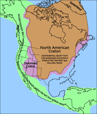
Laurentia or the North American Craton is a large continental craton that forms the ancient geological core of North America. Many times in its past, Laurentia has been a separate continent, as it is now in the form of North America, although originally it also included the cratonic areas of Greenland and also the northwestern part of Scotland, known as the Hebridean Terrane. During other times in its past, Laurentia has been part of larger continents and supercontinents and itself consists of many smaller terranes assembled on a network of Early Proterozoic orogenic belts. Small microcontinents and oceanic islands collided with and sutured onto the ever-growing Laurentia, and together formed the stable Precambrian craton seen today.

The Hebridean Terrane is one of the terranes that form part of the Caledonian orogenic belt in northwest Scotland. Its boundary with the neighbouring Northern Highland Terrane is formed by the Moine Thrust Belt. The basement is formed by Archaean and Paleoproterozoic gneisses of the Lewisian complex, unconformably overlain by the Neoproterozoic Torridonian sediments, which in turn are unconformably overlain by a sequence of Cambro–Ordovician sediments. It formed part of the Laurentian foreland during the Caledonian continental collision.

The Jordan Formation is a siliciclastic sedimentary rock unit identified in Illinois, Michigan, Wisconsin, Minnesota, and Iowa. Named for distinctive outcrops in the Minnesota River Valley near the town of Jordan, it extends throughout the Iowa Shelf and eastward over the Wisconsin Arch and Lincoln anticline into the Michigan Basin.
The Lexington Limestone is a prominent geologic formation that constitutes a large part of the late Ordovician bedrock of the inner Bluegrass region in Kentucky. Named after the city of Lexington, the geologic formation has heavily influenced both the surface topography and economy of the region.
The Black River Group is a geologic group that covers three sedimentary basins in the Eastern and Midwestern United States. These include the Appalachian Basin, Illinois Basin and the Michigan Basin. It dates back to the Late Ordovician period. It is roughly equivalent to the Platteville Group in Illinois. In Kentucky and Tennessee it is also known as the High Bridge Group. In areas where this Geologic Unit thins it is also called the Black River Formation (undifferentiated). One example of this is over the Cincinnati Arch & Findley Arch. Large parts of the Black River have been dolomized (where the parent limestone CaCO3 has been turned into dolomite CaMg(CO3)2.) This happed when there was interaction of hot saline brine and the limestone. This created hydrothermal dolomites that in some areas serve as petroleum reservoirs.
The Shady Dolomite is a geologic formation composed of marine sedimentary rocks of early Cambrian age. It outcrops along the eastern margin of the Blue Ridge province in the southeastern United States and can be found in outcrops in the states of Alabama, Georgia, Tennessee, North Carolina, and Virginia. It can also be found in the subsurface of Kentucky, Ohio, and West Virginia. The Shady is predominantly composed of dolomite and limestone with lesser amounts of mudrock. It contains fossils of trilobites, archaeocyathids, algae, brachiopods, and echinoderms, along with the enigmatic fossil Salterella. The Shady Dolomite was first described by Arthur Keith in 1903 and was named for exposures in the Shady Valley of Johnson County in the state of Tennessee. Near Austinville, Virginia, the Shady hosts ore deposits that have been mined extensively for lead and zinc ore.
The Vinini Formation is a marine, deep-water, sedimentary deposit of Ordovician to Early Silurian age in Nevada, U.S.A. It is notable for its highly varied, mainly siliceous composition, its mineral deposits, and controversies surrounding both its depositional environment and structural history. The formation was named by Merriam and Anderson for an occurrence along Vinini Creek in the Roberts Mountains of central Nevada and that name is now used extensively in the State.

The Dent Group is a group of Upper Ordovician sedimentary and volcanic rocks in north-west England. It is the lowermost part of the Windermere Supergroup, which was deposited in the foreland basin formed during the collision between Laurentia and Avalonia. It lies unconformably on the Borrowdale Volcanic Group. This unit was previously known as the Coniston Limestone Group or Coniston Limestone Formation and should not be confused with the significantly younger Coniston Group.

The Precordillera terrane of western Argentina is a large mountain range located southeast of the main Andes mountain range. The evolution of the Precordillera is noted for its unique formation history compared to the region nearby. The Cambrian-Ordovian sedimentology in the Precordillera terrane has its source neither from old Andes nor nearby country rock, but shares similar characteristics with the Grenville orogeny of eastern North America. This indicates a rift-drift history of the Precordillera in the early Paleozoic. The Precordillera is a moving micro-continent which started from the southeast part of the ancient continent Laurentia. The separation of the Precordillera started around the early Cambrian. The mass collided with Gondwana around Late Ordovician period. Different models and thinking of rift-drift process and the time of occurrence have been proposed. This page focuses on the evidence of drifting found in the stratigraphical record of the Precordillera, as well as exhibiting models of how the Precordillera drifted to Gondwana.
This article describes the geology of the Cairngorms National Park, an area in the Highlands of Scotland designated as a national park in 2003 and extended in 2010. The Cairngorms National Park extends across a much wider area than the Cairngorms massif itself and hence displays rather more varied geology.
The geology of Missouri includes deep Precambrian basement rocks formed within the last two billion years and overlain by thick sequences of marine sedimentary rocks, interspersed with igneous rocks by periods of volcanic activity. Missouri is a leading producer of lead from minerals formed in Paleozoic dolomite.
The geology of Yukon includes sections of ancient Precambrian Proterozoic rock from the western edge of the proto-North American continent Laurentia, with several different island arc terranes added through the Paleozoic, Mesozoic and Cenozoic, driving volcanism, pluton formation and sedimentation.
The Grampian orogeny was an orogeny mountain building event which affected Scotland in the middle of the Ordovician. At the time, Scotland was part of proto-North American continent Laurentia.
