Geology of Orkney

Last updated
Sketch geological map of Orkney OrkneyGeologyMap.png
Sketch geological map of Orkney

The geology of the Orkney islands in northern Scotland is dominated by the Devonian Old Red Sandstone (ORS). In the southwestern part of Mainland, this sequence can be seen to rest unconformably on a Moinian type metamorphic basement.

Contents

Metamorphic basement

Metamorphic rocks are exposed near Stromness and Yesnaby on Mainland and on Graemsay. [1] Most of the basement consists of granitic gneisses and later minor intrusions. These rocks are similar to those exposed in northern Caithness and have been correlated with the Loch Eil Group of the late Proterozoic Loch Ness Supergroup sequence. The unconformity at the base of the overlying Devonian rocks is highly irregular, with the exposed basement forming hills in this buried land surface.

Devonian

Dune cross-bedded aeolian Yesnaby Sandstone of probable Lower Devonian age, Yesnaby, Mainland Orkney Yensaby castle 1.JPG
Dune cross-bedded aeolian Yesnaby Sandstone of probable Lower Devonian age, Yesnaby, Mainland Orkney
Angular unconformity between Middle Devonian Lower Stromness Flagstone and underlying Yesnaby Sandstone of probable Lower Devonian age Unconformity base Middle Devonian Yesnaby.JPG
Angular unconformity between Middle Devonian Lower Stromness Flagstone and underlying Yesnaby Sandstone of probable Lower Devonian age
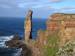
Old Man of Hoy, Upper Middle Devonian fluvial sandstones resting on basalt Old man of hoy2.jpg
Old Man of Hoy, Upper Middle Devonian fluvial sandstones resting on basalt
Brick-red Eday Marl, Bay of Birstane, reduced to green colour along fractures EdayMarl1.JPG
Brick-red Eday Marl, Bay of Birstane, reduced to green colour along fractures

The stratigraphic breakdown of the Devonian sequence has traditionally been into Lower, Middle and Upper ORS due to a general lack of biostratigraphic control. These divisions are now known to approximate to the Lower, Middle and Upper divisions of the Devonian. [2]

Lower Devonian

Rocks of probable lower Devonian age are exposed near Yesnaby, on western Mainland. A ridge of granitic basement divides the Harra Ebb Formation, a sequence of breccias, conglomerates and sandstones deposited in an alluvial fan setting, from the Yesnaby Sandstone which was deposited in an aeolian setting. [3] The contact with the overlying Middle Devonian lacustrine Lower Stromness Flagstones is an angular unconformity.

Middle Devonian

Most of the Old Red Sandstone of Orkney is Middle Devonian. [2] The lower part of the sequence, mostly Eifelian in age, is dominated by lacustrine beds of the lower and upper Stromness Flagstones that were deposited in Lake Orcadie. The two flagstones sequences are divided by the Sandwick fish bed, equivalent to the Achanarras formation of Caithness, representing an unusually persistent, deep and widespread lake that filled much of the Orcadian Basin. The sequence continues with the Rousay flagstones deposited in a similar lacustrine environment. The flagstones show a marked cyclicity in their sedimentation, with 86 such cycles being counted for the whole sequence. [4] These are interpreted as representing regular climatically driven changes in lake level caused by Milankovitch cyclicity.

The Eday Group overlies the Rousay Flagstones and represents a change to dominantly fluvial/aeolian deposition with only occasional lacustrine intervals. The Eday Group consists of three sandstone units, the lower, middle and upper Eday Sandstones separated by the Eday Flagstones and Eday Marl respectively. The Eday Marl consists mainly of red and green mudstones and siltstones and is thought to have been deposited in a river floodplain environment. [5] Locally pseudomorphs of halite have been found and rarely marine microfossils (scolecodonts) indicating that the basin was affected by occasional marine incursions at this time. [6]

The age and stratigraphic equivalents of the Hoy sandstone sequence are a matter of continuing debate. Traditionally the presence of an unconformity at the base of the lavas beneath these sandstones on southwestern Hoy has been interpreted to mark a major time break. [7] More recent studies have suggested that this unconformity is of only local significance as a hiatus of this age has not been recognised elsewhere in the Orcadian Basin sequence. [2] [8] It has been proposed that the Hoy sandstones are the lateral equivalents of the Eday Group, the thickness and associated facies changes being caused by active extensional faulting during deposition. [2] The presence of lavas within the Eday Flagstone Formation has been used to lend support to this idea, but differences in the chemistry between these lavas and those on Hoy mean that such a correlation remains uncertain. [9]

Upper Devonian

The Upper Eday Sandstone is considered to extend from the Upper Givetian into the Lower Frasnian in age. However, there is no biostratigraphic data available to confirm this suggestion. Hydrocarbon exploration wells drilled in the Inner and Outer Moray Firth basins show similar sequences continuing without break into the Lower Carboniferous. [2]

Structure

The Devonian and older rocks of Orkney are cut by a series of WSW-ENE to N-S trending faults, many of which were active during deposition of the Devonian sequences. The largest of these faults are the North Scapa Fault, East Scapa Fault and Bring-Risa Fault. [10] Both the North Scapa and Brims-Risa faults show evidence of local reversal along part of their lengths, [7] thought to be due to a period of transpressional deformation along the Great Glen Fault system that lies just to the east of the islands, during the Carboniferous. [11] Small-scale folding is common and one large-scale fold is developed, the north–south trending Eday syncline. This syncline is parallel to neighbouring normal faults and thickness variations in the lower Eday Sandstone indicate that this structure was active during the middle Devonian. [5]

Intrusions

Dykes of lamprophyre and more rarely dolerite are exposed in many parts of Orkney. [12] They trend mainly NE-SW to N-S and are dated as Late Permian, associated with a period of crustal extension. [13]

Petroleum geology

Quaternary Eolianite outcrop at Aikerness on the Mainland Aeolianite.jpg
Quaternary Eolianite outcrop at Aikerness on the Mainland

The presence of bitumens throughout Orkney show that hydrocarbons have at least locally been produced and migrated. The permanent lake laminites from the flagstone sequences are moderate to good source rocks and are currently marginally mature at the surface as a result of burial after the Devonian. [14] Two large exhumed oil accumulations have been described from Orkney, the Yesnaby and Houton Head reservoir systems. At Yesnaby bitumens occur throughout the presumed trap in the aeolian Yesnaby Sandstone with good porosity and permeability. At Houton Head, bitumens are found within a large area of aeolian/fluvial lower Eday Sandstone of similarly good reservoir characteristics. [14]

Quaternary deposits

Glacial and periglacial sediments are found locally throughout Orkney. A full history of the glaciations is not recorded with the last glaciation being the only event for which there is much evidence. [15]

Related Research Articles

<span class="mw-page-title-main">Orkney</span> Archipelago, county and council area in northern Scotland

Orkney, also known as the Orkney Islands, is an archipelago in the Northern Isles of Scotland, situated off the north coast of the island of Great Britain. Orkney is 10 miles (16 km) north of the coast of Caithness and has about 70 islands, of which 20 are inhabited. The largest island, the Mainland, has an area of 523 square kilometres (202 sq mi), making it the sixth-largest Scottish island and the tenth-largest island in the British Isles. Orkney's largest settlement, and also its administrative centre, is Kirkwall.

<span class="mw-page-title-main">Old Red Sandstone</span> Assemblage of rocks in the North Atlantic region

Old Red Sandstone, abbreviated ORS, is an assemblage of rocks in the North Atlantic region largely of Devonian age. It extends in the east across Great Britain, Ireland and Norway, and in the west along the eastern seaboard of North America. It also extends northwards into Greenland and Svalbard. These areas were a part of the paleocontinent of Euramerica (Laurussia). In Britain it is a lithostratigraphic unit to which stratigraphers accord supergroup status and which is of considerable importance to early paleontology. The presence of Old in the name is to distinguish the sequence from the younger New Red Sandstone which also occurs widely throughout Britain.

<span class="mw-page-title-main">Mainland, Orkney</span> Main island of the Orkney Islands, Scotland

The Mainland, also known as Hrossey and Pomona, is the main island of Orkney, Scotland. Both of Orkney's burghs, Kirkwall and Stromness, lie on the island, which is also the heart of Orkney's ferry and air connections.

<span class="mw-page-title-main">Eday</span> Island in the Orkney Islands, Scotland

Eday is one of the islands of Orkney, which are located to the north of the Scottish mainland. One of the North Isles, Eday is about 24 kilometres from the Orkney Mainland. With an area of 27 km2 (10 sq mi), it is the ninth-largest island of the archipelago. The bedrock of the island is Old Red Sandstone, which is exposed along the sea-cliffs.

The geology of Shropshire is very diverse with a large number of periods being represented at outcrop. The bedrock consists principally of sedimentary rocks of Palaeozoic and Mesozoic age, surrounding restricted areas of Precambrian metasedimentary and metavolcanic rocks. The county hosts in its Quaternary deposits and landforms, a significant record of recent glaciation. The exploitation of the Coal Measures and other Carboniferous age strata in the Ironbridge area made it one of the birthplaces of the Industrial Revolution. There is also a large amount of mineral wealth in the county, including lead and baryte. Quarrying is still active, with limestone for cement manufacture and concrete aggregate, sandstone, greywacke and dolerite for road aggregate, and sand and gravel for aggregate and drainage filters. Groundwater is an equally important economic resource.

<span class="mw-page-title-main">Highland Boundary Fault</span> Geological fault zone crossing Scotland

The Highland Boundary Fault is a major fault zone that traverses Scotland from Arran and Helensburgh on the west coast to Stonehaven in the east. It separates two different geological terranes which give rise to two distinct physiographic terrains: the Highlands and the Lowlands, and in most places it is recognisable as a change in topography. Where rivers cross the fault, they often pass through gorges, and the associated waterfalls can be a barrier to salmon migration.

The Orcadian Basin is a sedimentary basin of Devonian age that formed mainly as a result of extensional tectonics in northeastern Scotland after the end of the Caledonian orogeny. During part of its history, the basin was filled by a lake now known as Lake Orcadie. In that lacustrine environment, a sequence of finely bedded sedimentary rocks was deposited, containing well-preserved fish fossils, with alternating layers of mudstone and coarse siltstone to very fine sandstone. These flagstones split easily along the bedding and have been used as building material for thousands of years. The deposits of the Orcadian Basin form part of the Old Red Sandstone (ORS). The lithostratigraphic terms lower, middle and upper ORS, however, do not necessarily match exactly with sediments of lower, middle and upper Devonian age, as the base of the ORS is now known to be in the Silurian and the top in the Carboniferous.

<span class="mw-page-title-main">Yesnaby</span>

Yesnaby is an area in Sandwick, on the west coast of Orkney Mainland, Scotland, south of Skara Brae. It is renowned for its spectacular Old Red Sandstone coastal cliff scenery which includes sea stacks, blowholes, geos and frequently boiling seas. A car park, coastal trail and interpretive panels serve visitors. The area is popular with climbers because of Yesnaby Castle, a two-legged sea stack just south of the Brough of Bigging. The stack is sometimes described as a smaller version of the Old Man of Hoy. Yesnaby is also one of the very few places where Primula scotica grows.

<span class="mw-page-title-main">Hebridean Terrane</span> Part of the Caledonian orogenic belt in northwest Scotland

The Hebridean Terrane is one of the terranes that form part of the Caledonian orogenic belt in northwest Scotland. Its boundary with the neighbouring Northern Highland Terrane is formed by the Moine Thrust Belt. The basement is formed by Archaean and Paleoproterozoic gneisses of the Lewisian complex, unconformably overlain by the Neoproterozoic Torridonian sediments, which in turn are unconformably overlain by a sequence of Cambro–Ordovician sediments. It formed part of the Laurentian foreland during the Caledonian continental collision.

<span class="mw-page-title-main">Tankerness</span> Human settlement in Scotland

Tankerness is a district in the St Andrews parish in Mainland, Orkney, Scotland. Essentially a peninsula, it is about 13 kilometres (8 mi) south-east of Kirkwall and 1 kilometre (0.6 mi) east of Kirkwall Airport. The origin of the place name is uncertain, but it may derive from the Norse personal name "Tannskári". A "ness" is a promontory.

<span class="mw-page-title-main">Caithness Flagstone Group</span> Sequence of rock strata in Scotland

The Caithness Flagstone Group is a Devonian lithostratigraphic group in northern Scotland. The name is derived from the traditional county of Caithness where the strata are well exposed, especially in coastal cliffs.

<span class="mw-page-title-main">Eday Group</span> Group in Orkney Islands, Scotland, UK

The Eday Group is a Devonian lithostratigraphic group in Orkney, northern Scotland. The name is derived from the island of Eday where the strata are exposed in coastal cliffs.

<span class="mw-page-title-main">Shinumo Quartzite</span> Mesoproterozoic rock formation in the Grand Canyon, Arizona

The Shinumo Quartzite also known as the Shinumo Sandstone, is a Mesoproterozoic rock formation, which outcrops in the eastern Grand Canyon, Coconino County, Arizona,. It is the 3rd member of the 5-unit Unkar Group. The Shinumo Quartzite consists of a series of massive, cliff-forming sandstones and sedimentary quartzites. Its cliffs contrast sharply with the stair-stepped topography of typically brightly-colored strata of the underlying slope-forming Hakatai Shale. Overlying the Shinumo, dark green to black, fissile, slope-forming shales of the Dox Formation create a well-defined notch. It and other formations of the Unkar Group occur as isolated fault-bound remnants along the main stem of the Colorado River and its tributaries in Grand Canyon.

Typically, the Shinumo Quartzite and associated strata of the Unkar Group dip northeast (10°–30°) toward normal faults that dip 60+° toward the southwest. This can be seen at the Palisades fault in the eastern part of the main Unkar Group outcrop area.

<span class="mw-page-title-main">Geology of the Isle of Wight</span>

The geology of the Isle of Wight is dominated by sedimentary rocks of Cretaceous and Paleogene age. This sequence was affected by the late stages of the Alpine Orogeny, forming the Isle of Wight monocline, the cause of the steeply-dipping outcrops of the Chalk Group and overlying Paleogene strata seen at The Needles, Alum Bay and Whitecliff Bay.

<span class="mw-page-title-main">Geology of Iran</span>

The main points that are discussed in the geology of Iran include the study of the geological and structural units or zones; stratigraphy; magmatism and igneous rocks; ophiolite series and ultramafic rocks; and orogenic events in Iran.

<span class="mw-page-title-main">Geology of the southern North Sea</span> Largest gas producing basin

The North Sea basin is located in northern Europe and lies between the United Kingdom, and Norway just north of The Netherlands and can be divided into many sub-basins. The Southern North Sea basin is the largest gas producing basin in the UK continental shelf, with production coming from the lower Permian sandstones which are sealed by the upper Zechstein salt. The evolution of the North Sea basin occurred through multiple stages throughout the geologic timeline. First the creation of the Sub-Cambrian peneplain, followed by the Caledonian Orogeny in the late Silurian and early Devonian. Rift phases occurred in the late Paleozoic and early Mesozoic which allowed the opening of the northeastern Atlantic. Differential uplift occurred in the late Paleogene and Neogene. The geology of the Southern North Sea basin has a complex history of basinal subsidence that had occurred in the Paleozoic, Mesozoic, and Cenozoic. Uplift events occurred which were then followed by crustal extension which allowed rocks to become folded and faulted late in the Paleozoic. Tectonic movements allowed for halokinesis to occur with more uplift in the Mesozoic followed by a major phase of inversion occurred in the Cenozoic affecting many basins in northwestern Europe. The overall saucer-shaped geometry of the southern North Sea Basin indicates that the major faults have not been actively controlling sediment distribution.

<span class="mw-page-title-main">North German basin</span> Passive-active rift basin in central and west Europe

The North German Basin is a passive-active rift basin located in central and west Europe, lying within the southeasternmost portions of the North Sea and the southwestern Baltic Sea and across terrestrial portions of northern Germany, Netherlands, and Poland. The North German Basin is a sub-basin of the Southern Permian Basin, that accounts for a composite of intra-continental basins composed of Permian to Cenozoic sediments, which have accumulated to thicknesses around 10–12 kilometres (6–7.5 mi). The complex evolution of the basin takes place from the Permian to the Cenozoic, and is largely influenced by multiple stages of rifting, subsidence, and salt tectonic events. The North German Basin also accounts for a significant amount of Western Europe's natural gas resources, including one of the world's largest natural gas reservoir, the Groningen gas field.

The geology of Missouri includes deep Precambrian basement rocks formed within the last two billion years and overlain by thick sequences of marine sedimentary rocks, interspersed with igneous rocks by periods of volcanic activity. Missouri is a leading producer of lead from minerals formed in Paleozoic dolomite.

<span class="mw-page-title-main">Geology of Uzbekistan</span> Geology of Uzbekistan, an west Asian nation

The geology of Uzbekistan consists of two microcontinents and the remnants of oceanic crust, which fused together into a tectonically complex but resource rich land mass during the Paleozoic, before becoming draped in thick, primarily marine sedimentary units.

The geology of Lithuania consists of ancient Proterozoic basement rock overlain by thick sequences of Paleozoic, Mesozoic and Cenozoic marine sedimentary rocks, with some oil reserves, abundant limestone, dolomite, phosphorite and glauconite. Lithuania is a country in the Baltic region of northern-eastern Europe.

References

  1. Brown, J.F.; Hall, A. (2005). "Basement". Orkney Landscapes. Archived from the original on 3 March 2016. Retrieved 5 July 2009.
  2. 1 2 3 4 5 Marshall, J.E.A., & Hewett, A.J. 2003. Devonian. In: Evans, D., Graham C., Armour, A., & Bathurst, P. (eds), The Millennium Atlas: petroleum geology of the central and northern North Sea
  3. Brown, J.F.; Hall, A. (2005). "Lower Devonian". Orkney Landscapes. Archived from the original on 28 May 2014. Retrieved 5 July 2009.
  4. Brown, J.F.; Hall, A. (2005). "Lower Middle Devonian". Orkney Landforms. Archived from the original on 20 April 2016. Retrieved 5 July 2009.
  5. 1 2 Brown, J.F.; Hall, A. (2005). "Upper Middle and Upper Devonian". Orkney Landforms. Archived from the original on 28 October 2015. Retrieved 5 July 2009.
  6. Marshall, J.E.A.; Rogers, D.A.; Whiteley, M.J. (1996). "Devonian marine incursions into the Orcadian Basin, Scotland". Journal of the Geological Society. 153: 451–466. doi:10.1144/gsjgs.153.3.0451.
  7. 1 2 Mykura, W. (with contributions by Flinn, D, & May, F.) 1976. British Regional Geology: Orkney and Shetland, Institute of Geological Sciences, Natural Environment Council, 149pp.
  8. Underhill, J.R.; Brodie, J.A. (1993). "Structural geology of the Easter Ross Peninsula, Scotland: Implications for movement on the Great Glen Fault Zone". Journal of the Geological Society. 150: 515–527. doi:10.1144/gsjgs.150.3.0515.
  9. Odling, N.W.A. (2000). Stephenson, D.; Bevins, R.E.; Millward, D.; Highton, A.; Parsons, I.; Stone, P.; Wadsworth, W.J. (eds.). "Chapter 9: Late Silurian and Devonian volcanic rocks of Scotland, Site: Point of Ayre (HY 590 038)" (PDF). Volume 17: Caledonian Igneous Rocks of Great Britain. pp. 570–572. Retrieved 12 June 2024.
  10. "Land Use Consultants 1998. Orkney landscape character assessment. Scottish Natural Heritage Review No 100" (PDF). Archived from the original (PDF) on 2016-03-03. Retrieved 2009-07-05.
  11. Rogers, D.A., Marshall, J.E.A. and Astin, T.R. 1989. Devonian and later movements on the Great Glen fault system, Scotland. Journal of the Geological Society; 146: 369-372
  12. Brown, J.F.; Hall, A. "Permian dykes". Orkney Landforms. Archived from the original on 21 January 2012. Retrieved 5 July 2009.
  13. Brown, J.F. (1975). "Potassium–Argon evidence of a Permian age for the camptonite dykes: Orkney". Scottish Journal of Geology. 11: 259–262. doi:10.1144/sjg11030259.
  14. 1 2 Brown, J.F.; Hall, A. (2005). "Hydrocarbon Potential". Orkney Landforms. Archived from the original on 10 March 2012. Retrieved 5 July 2009.
  15. Brown, J.F.; Hall, A. (2005). "Ice Age Orkney". Archived from the original on 10 March 2012. Retrieved 5 July 2009.