| Scots name | Soond [1] |
|---|---|
| Old Norse name | Austrsker |
| Meaning of name | east skerry |
| Location | |
 Auskerry Auskerry shown within Orkney | |
| OS grid reference | HY675165 |
| Coordinates | 59°01′56″N2°34′11″W / 59.032267°N 2.569761°W |
| Physical geography | |
| Island group | Orkney |
| Area | 85 hectares (0.33 sq mi) |
| Area rank | 157= [2] |
| Highest elevation | 18 metres (59 ft) |
| Administration | |
| Council area | Orkney Islands |
| Country | Scotland |
| Sovereign state | United Kingdom |
| Demographics | |
| Population | 2 [3] |
| Population rank | 88= [2] |
| Population density | 2.35 people/km2 [3] [4] |
| References | [4] [5] [6] [7] |
| Auskerry Lighthouse | |
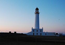 | |
| Constructed | 1866 |
| Built by | David Stevenson, Thomas Stevenson |
| Construction | stone |
| Automated | 1961 |
| Height | 34 m (112 ft) |
| Shape | cylindrical tower with balcony and lantern [8] [9] |
| Markings | white tower, black lantern, ochre trim |
| Power source | solar power |
| Operator | Northern Lighthouse Board |
| Heritage | category B listed building |
| Fog signal | None |
| Focal height | 34 m (112 ft) |
| Range | 20 nmi (37 km; 23 mi) |
| Characteristic | Fl W 20s |
Auskerry (Scots : Soond; Old Norse : Austrsker, east skerry) is a small island in eastern Orkney, Scotland. It lies in the North Sea south of Stronsay and has a lighthouse, completed in 1866.