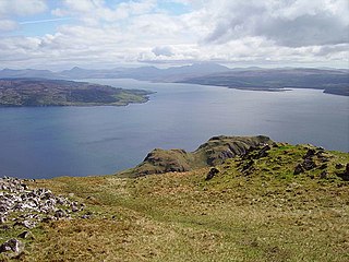
The island lies in the entrance to Loch Linnhe, separated from Lismore by a sound ¼ miles across.[3] It is a low-lying rock, ten acres (4.0 hectares) in size,[3] with some grass on it. CalMac ferries pass close to the island on their way from Oban to Mull.
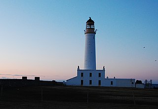
The lighthouse was built by Robert Stevenson in 1833 at a cost of £4260[4] and initially showed a fixed white light.[3] In 1910 most of the Northern Lighthouse Board's lights were changed to dioptric or Fresnel lenses but Lismore and Fidra, in the Firth of Forth, were left as the only remaining purely catoptric lights in the service.[3]
A Standing Stone once stood on the highest point of the island (NM779351). The 9-foot (2.7m) monolith appears to have recorded the midwinter sunset[clarification needed] and is thought to have been removed during construction of the lighthouse.[5]
The skerry of Lady's Rock lies a short distance to the south west.
The Islands of the Firth of Clyde are the fifth largest of the major Scottish island groups after the Inner and Outer Hebrides, Orkney and Shetland. They are situated in the Firth of Clyde between Argyll and Bute in the west and Inverclyde, North Ayrshire and South Ayrshire in the east. There are about forty islands and skerries. Only four are inhabited, and only nine are larger than 40 hectares. The largest and most populous are Arran and Bute. They are served by dedicated ferry routes, as are Great Cumbrae and Holy Island. Unlike the isles in the four larger Scottish archipelagos, none of the isles in this group are connected to one another or to the mainland by bridges.
Lismore is an island of some 2,351 hectares in the Inner Hebrides of Scotland. The climate is damp and mild, with over 166 centimetres (65 in) of rain recorded annually. This fertile, low-lying island was once a major centre of Celtic Christianity, with a 6th-century monastery associated with Saint Moluag, and later became the seat of the medieval Bishop of Argyll. There are numerous ruined structures, including a broch and two 13th-century castles.
Auskerry is a small island in eastern Orkney, Scotland. It lies in the North Sea south of Stronsay and has a lighthouse, completed in 1866.
The Flannan Isles or the Seven Hunters are a small island group in the Outer Hebrides of Scotland, approximately 32 kilometres west of the Isle of Lewis. They may take their name from Saint Flannan, the 7th century Irish preacher and abbot.
Erraid is a tidal island approximately one mile square located in the Inner Hebrides of Scotland. It lies west of Mull and southeast of Iona. The island receives about 1,000 millimetres (40 in) of rain and 1,350 hours of sunshine annually, making it one of the driest and sunniest places on the western seaboard of Scotland. It is attended by numerous uninhabited small islets, the largest being Eilean Dubh, Eilean nam Muc, Eilean Chalmain, Eilean Ghomain and Eilean na Seamair.
Eilean Chathastail is one of the Small Isles in the Inner Hebrides of Scotland.
Fidra is a currently uninhabited island in the Firth of Forth, 4 kilometres northwest of North Berwick, on the east coast of Scotland. The island is an RSPB Scotland nature reserve.
Skerryvore is a remote island that lies off the west coast of Scotland, 11 nautical miles southwest of Tiree. Skerryvore Lighthouse is located on these rocks, built with some difficulty between 1838 and 1844 by Alan Stevenson.
Eilean Bàn is a six-acre (2.4 ha) island between Kyle of Lochalsh and the Isle of Skye, in the historic county of Ross and Cromarty in the Highland local government area. The Skye Bridge uses the island as a stepping-stone as it crosses the mouth of Loch Alsh from the mainland to Skye.
Lunga is one of the Slate Islands in the Firth of Lorn in Argyll and Bute, Scotland. The "Grey Dog" tidal race, which runs in the sea channel to the south, reaches 8 knots (15 km/h) in full flood. The name "Lunga" is derived from the Old Norse for "isle of the longships', but almost all other place names are Gaelic in origin.
Shillay is the westernmost of the Monach Islands (Heisgeir), off North Uist in the Outer Hebrides.
Haskeir, also known as Great Haskeir is a remote, exposed and uninhabited island in the Outer Hebrides of Scotland. It lies 13 kilometres west-northwest of North Uist. One kilometre southwest lie the skerries of Haskeir Eagach, made up of a colonnade of five rock stacks, and 40 km (22 nmi) northwest is St Kilda.
Lady's Rock is an uninhabited skerry to the south west of Lismore in the Inner Hebrides. It is submerged at high tide and carries a navigation beacon. Eilean Musdile is to the north east, next to Lismore.
Eilean Trodday is an island in The Minch just off the north coast of the Trotternish peninsula of Skye in Scotland.
The Sound of Mull is a sound between the Inner Hebridean island of Mull and mainland Scotland. It forms part of the Atlantic Ocean.
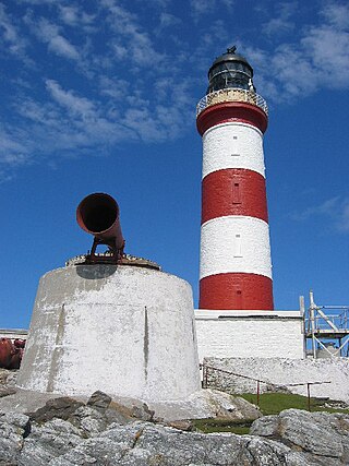
Eilean Glas Lighthouse is on the east coast of the island of Scalpay in the Outer Hebrides of Scotland. It was one of the original four lights commissioned by the Commissioners of the Northern Lights, and the first in the Hebrides. These lighthouses were built by Thomas Smith.
Flannan Isles Lighthouse is a lighthouse near the highest point on Eilean Mòr, one of the Flannan Isles in the Outer Hebrides off the west coast of Scotland. It is best known for the mysterious disappearance of its keepers in 1900.
The Cairns of Coll refers primarily to a region of rocky outcrops in shallow waters extending from the north end of the Island of Coll in the Inner Hebrides of Scotland. The extension is about 1.1 miles from shore, 1.6 if the Cairns of Coll Rocks 0.5 miles further are to be included. The outcrops of the Cairns are too small to be inhabited. The swift and unpredictable tidal currents between them make navigation hazardous to boats. They are rich in abundant and varied marine life, including the marine mammals.
This page is based on this Wikipedia article Text is available under the CC BY-SA 4.0 license; additional terms may apply. Images, videos and audio are available under their respective licenses.