
Bressay Lighthouse is a lighthouse in the Shetland Islands, Scotland, 4 kilometres (2.5 mi) south-east of Lerwick. It is located on the island of Bressay at Kirkabister Ness overlooking Bressay Sound.
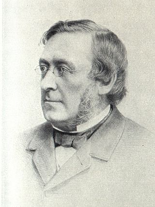
David Stevenson MICE FRSE FRSSA was a Scottish civil engineer and lighthouse designer who designed over 30 lighthouses in and around Scotland, and helped continue the dynasty of lighthouse engineering founded by his father, Robert Stevenson.

Muckle Flugga lighthouse punctuates the rocky stack of Muckle Flugga, in Shetland, Scotland. Originally called North Unst Lighthouse, it was renamed in 1964.

Ardmhor is a small village in the north east of the Isle of Barra in the Outer Hebrides, Scotland.

Fidra is a currently uninhabited island in the Firth of Forth, 4 kilometres northwest of North Berwick, on the east coast of Scotland. The island is an RSPB Scotland nature reserve.

Muckle Skerry is the largest of the Pentland Skerries that lie off the north coast of Scotland. It is home to the Pentland Skerries Lighthouse.

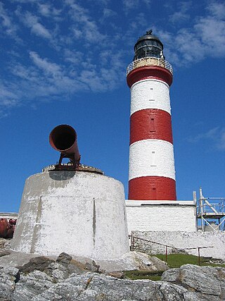
Duncansby Head is the most northeasterly part of both the Scottish and British mainlands, slightly northeast of John o' Groats. It lies approximately 20 km (12 mi) east-southeast of Dunnet Head, the northernmost point of both the Scottish and British mainlands. Duncansby Head is in Caithness, Highland, in north-eastern Scotland. The headland juts into the North Sea, with the Pentland Firth to its north and west and the Moray Firth to its south.

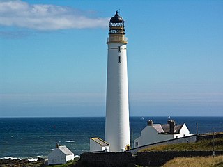
Covesea Skerries Lighthouse, originally belonging to the Northern Lighthouse Board (NLB), is built on top of a small headland on the south coast of the Moray Firth at Covesea, near Lossiemouth, Moray, Scotland.

Eshaness Lighthouse is situated on the Northmavine peninsula in the north-west of the Shetland Islands, Scotland. It sometimes rendered as Esha Ness Lighthouse.

Rattray Head, historically Rattray Point, is a headland in Buchan, Aberdeenshire, on the north-east coast Scotland. To north lies Strathbeg Bay and Rattray Bay is to its south. The dunes at Rattray Head beach can be up to 75 feet (23 m) high and stretch 17 miles (27 km) from St Combs to Peterhead.

The Ailsa Craig Lighthouse, is an active 19th century lighthouse located on Ailsa Craig, an island in the Firth of Clyde, just offshore from Girvan, South Ayrshire, Scotland.

Shillay is the westernmost of the Monach Islands (Heisgeir), off North Uist in the Outer Hebrides.

Haskeir, also known as Great Haskeir is a remote, exposed and uninhabited island in the Outer Hebrides of Scotland. It lies 13 kilometres west-northwest of North Uist. One kilometre southwest lie the skerries of Haskeir Eagach, made up of a colonnade of five rock stacks, and 40 km (22 nmi) northwest is St Kilda.

Eilean Musdile (Mansedale) is an islet, and lighthouse to the south west of Lismore in the Inner Hebrides.
Scurdie Ness is a headland located on the South side of the River South Esk estuary, Montrose, Angus, Scotland. The River leads from the North Sea into Montrose Harbour and then into Montrose Basin. The headland has also been referred to as Scurdy Ness, Montrose point or Montroseness. The word Scurdie is a local word for the volcanic rock found there and Ness means a promontory, cape or headland. The coastline from Scurdie Ness to Rickle Craig has been designated a Site of Special Scientific Interest.
Weavers Point is a headland to the north of the entrance to Loch Maddy, on the north eastern coastline of North Uist in the Western Isles of Scotland. There has been a lighthouse on the headland since 1980.

Ushenish is a headland on the remote east coast of South Uist in the Outer Hebrides of Scotland. Ushenish Lighthouse has been on the headland since 1857.
Eilean Glas Lighthouse is on the east coast of the island of Scalpay in the Outer Hebrides of Scotland. It was one of the original four lights commissioned by the Commissioners of the Northern Lights, and the first in the Hebrides. These lighthouses were built by Thomas Smith.

The Cantick Head Lighthouse is an active 19th century lighthouse on the Scottish island of South Walls in the Orkney Islands. It is located at the end of Cantick Head, a long peninsula on the south-eastern coast of South Walls that overlooks the Pentland Firth and the Sound of Hoxa, which forms the southern entry to the natural harbour of Scapa Flow.
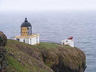
St Abb's Head Lighthouse stands on the cliffs at the rocky promontory of St Abb's Head, near the village of St Abbs in Berwickshire.

