Location | Scalpay Lewis and Harris Outer Hebrides Scotland [1] |
---|---|
OS grid | NG2474894722 |
Coordinates | 57°51′25″N6°38′31″W / 57.856916°N 6.642069°W |
Tower | |
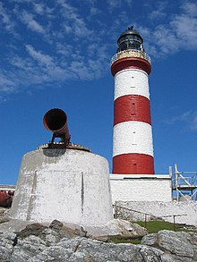
Constructed | 1789 (first) |
Designed by | Thomas Smith |
Construction | masonry tower (current) stone tower (first) |
Automated | 1978 |
Height | 30 metres (98 ft) |
Shape | cylindrical tower with balcony and lantern |
Markings | tower with red and white bands, black lantern |
Operator | Northern Lighthouse Board [2] [3] |
Heritage | category A listed building |
Light | |
First lit | 1824 (current by Robert Stevenson) |
Deactivated | 1824 (first) |
Focal height | 43 metres (141 ft) |
Lens | catoptric sealed beam lamps |
Intensity | 400,000 candela |
Range | 23 nautical miles (43 km; 26 mi) |
Characteristic | Fl (3) W 20s. |
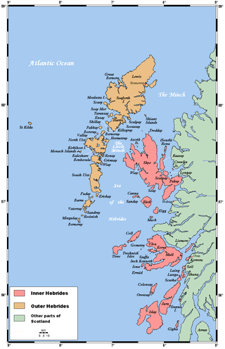
Eilean Glas Lighthouse is on the east coast of the island of Scalpay in the Outer Hebrides of Scotland. It was one of the original four lights commissioned by the Commissioners of the Northern Lights, and the first in the Hebrides [1] (the others were Kinnaird Head, Mull of Kintyre and North Ronaldsay). These lighthouses were built by Thomas Smith. [1]
Eilean Glas light was first displayed in 1789. The original tower was replaced in 1824 by Smith's stepson Robert Stevenson. In 1852 the light was changed to a revolving system lens. The lighthouse was an early candidate for automation and this was carried out in 1978. Several of the original buildings have been sold off. [1] The fog signal was discontinued in the 1980s although the horn remains in place as a decoration.
The 30-metre (98 ft) tower is painted with two distinctive broad red bands. Light is now from catoptric sealed beam lamps, (similar to car head lights) mounted on a gearless pedestal. [1]
In 2004, the owners of the lighthouse building were convicted of theft and of running a fraudulent charity to pay for the mortgage on the property. [4] Their 3-year sentence was later reduced to 2 years at the Court of Appeal. [5]
The lighthouse is owned and operated by the Northern Lighthouse Board, and the site's other buildings are owned by North Harris Trust and Eilean Glas Trust. [6] The site is a Category A listed building. [7]
The Outer Hebrides or Western Isles, sometimes known as the Long Isle or Long Island, is an island chain off the west coast of mainland Scotland. The islands are geographically coextensive with Comhairle nan Eilean Siar, one of the 32 unitary council areas of Scotland. They form part of the archipelago of the Hebrides, separated from the Scottish mainland and from the Inner Hebrides by the waters of the Minch, the Little Minch, and the Sea of the Hebrides. The islands are today considered to be the traditional heartland of the Gaelic language.
Harris is the southern and more mountainous part of Lewis and Harris, the largest island in the Outer Hebrides, Scotland. Although not an island itself, Harris is often referred to in opposition to the Isle of Lewis as the Isle of Harris, which is the former postal county and the current post town for Royal Mail postcodes starting HS3 or HS5.
Scalpay is an island in the Outer Hebrides of Scotland.
The Flannan Isles or the Seven Hunters are a small island group in the Outer Hebrides of Scotland, approximately 32 kilometres west of the Isle of Lewis. They may take their name from Saint Flannan, the 7th century Irish preacher and abbot.
The Minch is a strait in north-west Scotland that separates the mainland from Lewis and Harris in the Outer Hebrides. It was known as Skotlandsfjörð in Old Norse.
The Northern Lighthouse Board (NLB) is the general lighthouse authority for Scotland and the Isle of Man. It is a non-departmental public body responsible for marine navigation aids around coastal areas.
Thomas Smith was a Scottish businessman and early lighthouse engineer. He was appointed as the first Chief Engineer to the Northern Lighthouse Board in 1786.
Eilean Bàn is a six-acre (2.4 ha) island between Kyle of Lochalsh and the Isle of Skye, in the historic county of Ross and Cromarty in the Highland local government area. The Skye Bridge uses the island as a stepping-stone as it crosses the mouth of Loch Alsh from the mainland to Skye.
The Hebrides were settled early on in the settlement of the British Isles, perhaps as early as the Mesolithic era, around 8500–8250 BC, after the climatic conditions improved enough to sustain human settlement. There are examples of structures possibly dating from up to 3000 BC, the finest example being the standing stones at Callanish, but some archaeologists date the site as Bronze Age. Little is known of the people who settled in the Hebrides but they were likely of the same Celtic stock that had settled in the rest of Scotland. Settlements at Northton, Harris, have both Beaker & Neolithic dwelling houses, the oldest in the Western Isles, attesting to the settlement.
Ornsay is a small tidal island to the east of the Sleat peninsula on the Isle of Skye in the Inner Hebrides of Scotland.
Shillay is the westernmost of the Monach Islands (Heisgeir), off North Uist in the Outer Hebrides.
Eilean Musdile (Mansedale) is an islet, and lighthouse to the south west of Lismore in the Inner Hebrides.
Eilean Trodday is an island in The Minch just off the north coast of the Trotternish peninsula of Skye in Scotland.
Ardnamurchan Lighthouse is a listed 19th century lighthouse, located on Ardnamurchan Point in Lochaber part of the Highland council area of Scotland. The lighthouse with its 36-metre-tall (118 ft), pink granite tower was completed in 1849 to a design by Alan Stevenson. It is the only lighthouse in the UK built in the Egyptian style. Mains electricity was installed in 1976, the light was automated in 1988 and is now operated remotely by the Northern Lighthouse Board from Edinburgh.
Barra Head Lighthouse on Barra Head identifies the southern entrance to The Minch, roughly halfway between the Eilean Glas and Rinns of Islay lighthouses. The 58-foot (18-metre) stone tower, built in 1833, stands on the west side of the island, at the top of a very steep cliff, making the light the highest in the UK with a focal plane of 208 m (682 ft) above sea level. It has a range of 18 nautical miles. There is no shallow water west of Berneray to break the blow of the Atlantic storms and small fish are sometimes thrown onto the grass on the cliff top. In 1836 Sir Archibald Geikie recorded the movement of a 42-long-ton (43-tonne) block of gneiss across 5 feet (1.5 m) of ground during a violent storm.