Hoy is an island in Orkney, Scotland, measuring 143 square kilometres (55 sq mi) – the second largest in the archipelago, after Mainland. A natural causeway, the Ayre, links the island to the smaller South Walls; the two islands are treated as one entity by the UK census. Hoy is also the name of a hamlet in the northwest of the island.

The Mainland, also known as Hrossey and Pomona, is the main island of Orkney, Scotland. Both of Orkney's burghs, Kirkwall and Stromness, lie on the island, which is also the heart of Orkney's ferry and air connections.

Stronsay is an island in Orkney, Scotland. It is known as Orkney's 'Island of Bays', owing to an irregular shape with miles of coastline, with three large bays separated by two isthmuses: St Catherine's Bay to the west, the Bay of Holland to the south and Mill Bay to the east. Stronsay is 3,275 hectares in area, and 44 metres in altitude at its highest point. It has a usually resident population of 349. The main village is Whitehall, home to a heritage centre.
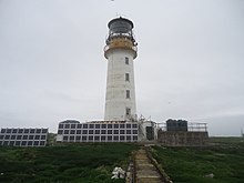
Auskerry is a small island in eastern Orkney, Scotland. It lies in the North Sea south of Stronsay and has a lighthouse, completed in 1866.

Copinsay is one of the Orkney Islands in Scotland, lying off the east coast of the Orkney Mainland. The smaller companion island to Copinsay, Horse of Copinsay lies to the northeast. The Horse is uninhabited, and is managed as a bird reserve. Copinsay is also home to a lighthouse.

Swona is an uninhabited privately owned island in the Pentland Firth off the north coast of Scotland. It has a herd of feral cattle resulting from the abandonment of stock in 1974.

The Flannan Isles or the Seven Hunters are a small island group in the Outer Hebrides of Scotland, approximately 32 kilometres west of the Isle of Lewis. They may take their name from Saint Flannan, the 7th century Irish preacher and abbot.
Soay is an uninhabited islet in the St Kilda archipelago, Scotland. The name is from Old Norse Sauðey, meaning "island of sheep". The island is part of the St Kilda World Heritage Site and home to a primitive breed of sheep. Excluding Rockall, it is the westernmost point of the United Kingdom.
Hermaness is the northernmost headland of Unst, the most northerly inhabited island of Shetland, Scotland. It consists of huge sea cliffs and moorland, making it an ideal habitat for a variety of birds. Hermaness was designated a national nature reserve (NNR) in 1955. The NNR extends over 965 hectares, including the whole of the Hermaness peninsula and the outlying Muckle Flugga and Out Stack. The reserve has a path and boardwalk that extends out onto the moorland. The reserve is managed by NatureScot, though it remains in private ownership, with most being owned by the Buness Estate, although the stacks and skerries around Muckle Flugga are owned by the Northern Lighthouse Board.

Fidra is a currently uninhabited island in the Firth of Forth, 4 kilometres northwest of North Berwick, on the east coast of Scotland. The island is an RSPB Scotland nature reserve.
Baccalieu Island or Bacalhoo Island is a 5 km2 uninhabited island at the northern extremities of Conception Bay in Subdivision 1G, near the community of Red Head Cove, Newfoundland and Labrador, Canada. It is separated from the island of Newfoundland by Baccalieu Tickle, a small strait and an abundant fishing ground. The island has some trees but is mostly rocky.

Sule Stack or Stack Skerry is an extremely remote island or stack in the North Atlantic off the north coast of Scotland. It is formed of Lewisian gneiss.
The Skerries, coming from the Old Norse word sker, are a group of sparsely vegetated rocky islets (skerries), with a total area of about 17 hectares lying 3 kilometres (1.9 mi) offshore from Carmel Head at the northwest corner of Anglesey, Wales. The islands are important as a breeding site for seabirds, and they attract divers, who come to visit the numerous shipwrecks. The Skerries Lighthouse sits atop the highest point in the islands.

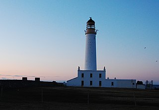
Muckle Skerry is the largest of the Pentland Skerries that lie off the north coast of Scotland. It is home to the Pentland Skerries Lighthouse.

Sumburgh Head is a headland located at the southern tip of the main island of the Shetland Archipelago, in northern Scotland. The head consists of a 100 m high rocky spur and topped by the Sumburgh Head Lighthouse. In the Old Norse language, Sumburgh Head was called Dunrøstar høfdi, it means "The Head onto the loud tide-race", referring to the noise of Sumburgh Roost. Robert Stevenson was the engineer in charge of building the Sumburgh Head lighthouse. Work started on the building in 1819, and the light was first lit in 1821.

Sula Sgeir is a small, uninhabited Scottish islet in the North Atlantic, 18 kilometres west of Rona. One of the most remote islands of the British Isles, it lies approximately forty nautical miles north of Lewis and is best known for its population of gannets. It has a narrow elongated shape running north-northeast to south-southwest, and is approximately 900 m long by typically 100 m wide.

The Islands of the Forth are a group of small islands located in the Firth of Forth and in the estuary of the River Forth on the east coast of Scotland. Most of the group lie in the open waters of the firth, between the Lothians and Fife, with the majority to the east of the city of Edinburgh. Two islands lie further west in the river estuary.
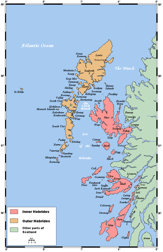
The flora and fauna of the Outer Hebrides in northwest Scotland comprises a unique and diverse ecosystem. A long archipelago, set on the eastern shores of the Atlantic Ocean, it attracts a wide variety of seabirds, and thanks to the Gulf Stream a climate more mild than might be expected at this latitude. Because it is on the Gulf Stream, it also occasionally gets exotic visitors.