
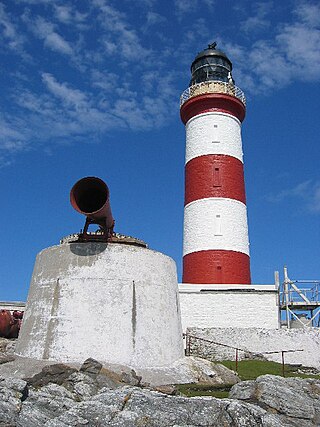
The Bell Rock Lighthouse, off the coast of Angus, Scotland, is the world's oldest surviving sea-washed lighthouse. It was built between 1807 and 1810 by Robert Stevenson on the Bell Rock in the North Sea, 11 miles (18 km) east of the Firth of Tay. Standing 35 metres (115 ft) tall, its light is visible from 35 statute miles (56 km) inland.

Graemsay is an island in the western approaches to Scapa Flow, in the Orkney Islands of Scotland. The island has two lighthouses. Graemsay lies within the parish of Stromness.

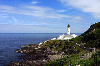
The Mull of Galloway is the southernmost point of Scotland. It is situated in Wigtownshire, Dumfries and Galloway, at the end of the Rhins of Galloway peninsula.

Muckle Flugga lighthouse punctuates the rocky stack of Muckle Flugga, in Shetland, Scotland. Originally called North Unst Lighthouse, it was renamed in 1964.
Skerryvore is a remote island that lies off the west coast of Scotland, 11 nautical miles southwest of Tiree. Skerryvore Lighthouse is located on these rocks, built with some difficulty between 1838 and 1844 by Alan Stevenson.

Dubh Artach is a remote skerry of basalt rock off the west coast of Scotland lying 18 miles (29 km) west of Colonsay and 15 miles (24 km) south-west of the Ross of Mull.

The Tarbat Ness Lighthouse is located at the North West tip of the Tarbat Ness peninsula near the fishing village of Portmahomack on the east coast of Scotland. It was built in 1830 by Robert Stevenson and has an elevation of 53 metres (174 ft) and 203 steps to the top of the tower.

Cape Wrath Lighthouse at Cape Wrath was built in 1828 by Robert Stevenson and was manned until 1998, when it was converted to automatic operation by the Northern Lighthouse Board. It is located at the most North-Westerly point on the British mainland, in the traditional county of Sutherland within Highland Region. Durness is the closest village, 10 miles (16 km) to the south-east with Inverness around 120 miles (190 km) to the south.
Douglas Head Lighthouse is a lighthouse at Douglas Head on the Isle of Man located between England and Ireland.

Eshaness Lighthouse is situated on the Northmavine peninsula in the north-west of the Shetland Islands, Scotland. It sometimes rendered as Esha Ness Lighthouse.

Cape Cleveland Light is an active heritage-listed lighthouse located on the northern tip of Cape Cleveland, a promontory projecting into the Coral Sea west of Cleveland Bay in the locality of Cape Cleveland about 40 kilometres (25 mi) east of Townsville, Queensland, Australia. The lighthouse marks the northern point of the Cape, and the entrance to Cleveland Bay.

Ardnamurchan Lighthouse is a listed 19th century lighthouse, located on Ardnamurchan Point in Lochaber part of the Highland council area of Scotland. The lighthouse with its 36-metre-tall (118 ft), pink granite tower was completed in 1849 to a design by Alan Stevenson. It is the only lighthouse in the UK built in the Egyptian style. Mains electricity was installed in 1976, the light was automated in 1988 and is now operated remotely by the Northern Lighthouse Board from Edinburgh.
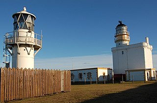
There are two lighthouses located on Kinnaird Head, in Fraserburgh, Scotland: an historical one built in a converted castle; and its modern replacement, built in 1991.
Eilean Glas Lighthouse is situated on the east coast of the island of Scalpay in the Outer Hebrides of Scotland. It was one of the original four lights commissioned by the Commissioners of the Northern Lights, and the first in the Hebrides. These lighthouses were built by Thomas Smith.

Barra Head Lighthouse on Barra Head identifies the southern entrance to The Minch, roughly halfway between the Eilean Glas and Rinns of Islay lighthouses. The 58-foot (18-metre) stone tower, built in 1833, stands on the west side of the island, at the top of a very steep cliff, making the light the highest in the UK with a focal plane of 208 m (682 ft) above sea level. It has a range of 18 nautical miles. There is no shallow water west of Berneray to break the blow of the Atlantic storms and small fish are sometimes thrown onto the grass on the cliff top. In 1836 Sir Archibald Geikie recorded the movement of a 42-long-ton (43-tonne) block of gneiss across 5 feet (1.5 m) of ground during a violent storm.

The Noss Head Lighthouse is an active 19th-century lighthouse near Wick in Caithness in the Highland council area of Scotland. It is located at the end of Noss Head, a peninsula on the north-west coast of Caithness that overlooks Sinclairs Bay, three miles north-east of Wick. It is notable as being the first lighthouse that was built with a diagonally-paned lantern room.

The Chicken Rock Lighthouse is an active 19th-century lighthouse, located on Chicken Rock, an isolated island at the southern end of the Isle of Man. Completed in 1874, the 44-metre-high (144 ft) tower is constructed of tapered granite and was designed by David and Thomas Stevenson. The need for the light on Chicken Rock was identified as early as 1866, due to the problem of fog obscuring the two lights on the nearby Calf of Man. As these lights formed a transit with the Chickens, the loss of any one exposed shipping to danger.
Maughold Head Lighthouse is an active 20th century lighthouse, located on the headland of the same name at the southern end of Ramsey Bay on the eastern coast of the Isle of Man. Completed in 1914, it was designed by David A and Charles Stevenson.

The Ruvaal, Rhuvaal, or Rubh'a' Mhàil Lighthouse is a listed 19th-century lighthouse located at the north-eastern end of the island of Islay, in the Inner Hebrides off the west coast of Scotland. The active lighthouse marks the northern approaches to the Sound of Islay, a narrow channel separating Islay from the adjacent island of Jura, and is one of the seven lighthouses operated by the Northern Lighthouse Board, which act as maritime aids to navigation on and around Islay.

Girdle Ness Lighthouse is situated near Torry Battery on the Girdle Ness peninsula just south of the entrance to Aberdeen's harbour, in Scotland. It is an active light, managed by the Northern Lighthouse Board.


