Cape Wrath Lighthouse

Last updated

Cape Wrath Lighthouse
Am Parbh
Cape Wrath lighthouse.jpg
Cape Wrath Lighthouse
Location Sutherland
Scotland
OS grid NC2595574726
Coordinates 58°37′31.6″N4°59′55.9″W / 58.625444°N 4.998861°W / 58.625444; -4.998861
Tower
Constructed1828
Built by Robert Stevenson   OOjs UI icon edit-ltr-progressive.svg
Constructiongranite tower
Automated1998
Height20 metres (66 ft)
Shapecylindrical tower with balcony and lantern attached to keeper's house
Markingswhite tower, black lantern, ochre trim
Power sourcemains electricity  OOjs UI icon edit-ltr-progressive.svg
OperatorNorthern Lighthouse Board [1] [2]
Heritagecategory A listed building  OOjs UI icon edit-ltr-progressive.svg
Light
Focal height122 metres (400 ft)
Range22 nautical miles (41 km; 25 mi)
Characteristic Fl (4) W 30s.

Cape Wrath Lighthouse at Cape Wrath was built in 1828 by Robert Stevenson and was manned until 1998, when it was converted to automatic operation by the Northern Lighthouse Board. [3] [4] It is located at the most North-Westerly point on the British mainland, in the traditional county of Sutherland within Highland Region. Durness is the closest village, 10 miles (16 km) to the south-east with Inverness around 120 miles (190 km) to the south.

Contents

Overlooking the Cape are the ruins of the Lloyd's signal station, which was used to monitor shipping and was built in the 19th century. [5] [6] The light, which is 122 metres (400 ft) above sea level, is visible for 22 nautical miles (41 km; 25 mi). [3]

History

The lighthouse was built in 1828. Due to its height the light was often obscured by low cloud or fog and in the early 20th century plans were drawn up to build an additional low light. This involved the construction of tunnels into the headland, bridges and building on the very tip of the rocks below the headland. Plans were drawn up by David Alan Stevenson, Robert's grandson and work began in 1913 but was suspended at the start of World War I and never restarted. [7]

The light was originally a paraffin lamp with red and white reflectors. This was replaced by mercury vapour lamps in 1978 and in 1980 an electrical temporary power beam was installed with a gear less pedestal and array system later in the same year. The fog-horn at the site was discontinued in 2001. [7]

Current display

The current light characteristic is four white flashes every 30 seconds (Fl(4).W.30s) and is visible for 22 nautical miles (41 km; 25 mi). [3] The optics are a first order Fresnel lens and the light has a power rating of 200,000 candela. [7]

Buildings and access routes
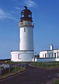
The lighthouse is a 20 metres (66 ft) tall white-washed tower built of granite with a single storey semi-circular base building. [8] A number of lighthouse keepers cottages and store buildings are located near to the lighthouse, with the complex surrounded by a perimeter wall. [8] [9] The lighthouse and its associated buildings are designated as a Category A listed building. [8] Much of the material for the lighthouse was quarried locally during construction, particularly from Clais Charnach. [7]

A complex of buildings was built close to the lighthouse by Lloyd's of London as a signal station between 1894 and 1903. [6] These buildings, which are Category B listed buildings, form one of the few remaining sites of Lloyds signal stations in the UK. [6] The signal station was built to track shipping around Cape Wrath and was closed in 1932, although the site was reused in 1939 as an observation post at the outbreak of World War II. [6] A new coastguard station was built next to the signalling station in the 1940s for wartime use. [5] The signal station and coastguard station buildings are largely derelict. [6]

Cape Wrath and the lighthouse from the sea Cape Wrath from seaward - geograph.org.uk - 344806.jpg
Cape Wrath and the lighthouse from the sea

A slipway was built in 1827, prior to construction of the lighthouse, at Clais Charnach, a steep sided gully around 1.7 miles (2.7 km) south-east of the lighthouse. [10] This was used during the building of the lighthouse to supply materials along a rough road and was the main landing point for supplies and stores during the manned operation of the lighthouse, although from 1977 onwards helicopters were also used for resupply. [7] Store buildings were constructed at the same time, one of which is still in use by the Ministry of Defence. The slipway was extended and rebuilt in around 1863 and remains in use as a landing site for the lighthouse. [10] The access road from the Kyle of Durness was built to support the lighthouse in 1828. [11]

The lighthouse is now considered to be the end of the Cape Wrath Trail, an approximately 200 mile long very rugged walking trail from Fort William.

See also

Related Research Articles

<span class="mw-page-title-main">Fair Isle</span> Island in Shetland, Scotland

Fair Isle, sometimes Fairisle, is an island in Shetland, in northern Scotland. It lies about halfway between mainland Shetland and Orkney. The most remote inhabited island in the United Kingdom, it is known for its bird observatory and a traditional style of knitting. The island has been owned by the National Trust for Scotland since 1954.

<span class="mw-page-title-main">Bell Rock Lighthouse</span> Worlds oldest working sea-washed lighthouse, off the coast of Angus, Scotland

The Bell Rock Lighthouse, off the coast of Angus, Scotland, is the world's oldest surviving sea-washed lighthouse. It was built between 1807 and 1810 by Robert Stevenson on the Bell Rock in the North Sea, 11 miles (18 km) east of the Firth of Tay. Standing 35 metres (115 ft) tall, its light is visible from 35 statute miles (56 km) inland.

<span class="mw-page-title-main">Tynemouth</span> Human settlement in England

Tynemouth is a coastal town in the metropolitan borough of North Tyneside, England. It is located on the north side of the mouth of the River Tyne, hence its name. It is 8 mi (13 km) east-northeast of Newcastle upon Tyne. It is best known for Tynemouth Priory.

<span class="mw-page-title-main">Cape Wrath</span> Cape in Scotland

Cape Wrath is a cape in the Durness parish of the county of Sutherland in the Highlands of Scotland. It is the most north-westerly point in mainland Britain.

<span class="mw-page-title-main">Durness</span> Human settlement in Scotland

Durness is a village and civil parish in the north-west Highlands of Scotland. It lies on the north coast of the country in the traditional county of Sutherland, around 120 miles north of Inverness. The area is remote, and the parish is huge and sparsely populated, covering an area from east of Loch Eriboll to Cape Wrath, the most north-westerly point of the Scottish mainland.

<span class="mw-page-title-main">Faraid Head</span>

Faraid Head is a small peninsula on the northern coast of Sutherland, Highland, Scotland, located around 2 miles north of the hamlet of Balnakeil and 3 mi (5 km) north of Durness.

<span class="mw-page-title-main">Fife Ness</span> Headland and most eastern point of Fife, Scotland

Fife Ness is a headland forming the most eastern point in Fife, Scotland. Anciently the area was called Muck Ross, which is a corruption of the Scottish Gaelic Muc-Rois meaning "Headland of the Pigs". It is situated in the area of Fife known as the East Neuk, and forms the muzzle of the dog-like outline of the latter when viewed on a map. Ness is an archaic Norse word meaning "nose".

<span class="mw-page-title-main">Achiemore, Durness</span> Human settlement in Scotland

Achiemore was a crofting community located on the Cape Wrath peninsula near the village of Durness in the Scottish county of Sutherland. The hamlet is just south of the farmstead of Daill on the western shore of the Kyle of Durness. Neither place has a permanent population with the village of Durness located 2.5 miles (4.0 km) to the east. Inverness is around 120 miles (190 km) to the south.

<span class="mw-page-title-main">Spectacle Reef Light</span> Lighthouse in Michigan, United States

Spectacle Reef Light is a lighthouse 11 miles (18 km) east of the Straits of Mackinac and is located at the northern end of Lake Huron, Michigan. It was designed and built by Colonel Orlando Metcalfe Poe and Major Godfrey Weitzel, and was the most expensive lighthouse ever built on the Great Lakes.

<span class="mw-page-title-main">Scurdie Ness</span> Lighthouse

Scurdie Ness is a headland located on the South side of the River South Esk estuary, Montrose, Angus, Scotland. The River leads from the North Sea into Montrose Harbour and then into Montrose Basin. The headland has also been referred to as Scurdy Ness, Montrose point or Montroseness. The word Scurdie is a local word for the volcanic rock found there and Ness means a promontory, cape or headland. The coastline from Scurdie Ness to Rickle Craig has been designated a Site of Special Scientific Interest.

<span class="mw-page-title-main">Bass Point (England)</span> Headland on the coast of Cornwall, England, UK

Bass Point is a headland on the coast of Cornwall, England, UK. It is at the southern tip of the Lizard peninsula, in the civil parish of Landewednack. The headland was a communications centre, during the Victorian era with the Lloyds Signal Station, opened in 1872 for shore to ship communications and Marconi's experiments with wireless at the Lizard Wireless Station.

<span class="mw-page-title-main">Balnakeil</span> Human settlement in Scotland

Balnakeil is a hamlet in the parish of Durness, Sutherland, Scottish Highlands, and is in the Scottish council area of Highland. It is on the north coast of Scotland around 34 mile northwest of Durness. The ruins of Balnakeil Church are a scheduled monument. The Kyle of Durness is west of Balnakeil which gives its name to the 2-mile-wide (3-kilometre) Balnakeil Bay which the Kyle opens into.

<span class="mw-page-title-main">Slettnes Lighthouse</span> Lighthouse

Slettnes Lighthouse is the northernmost mainland lighthouse on Earth. It is located in Gamvik Municipality in Troms og Finnmark county, Norway. It sits along the Barents Sea approximately 3 kilometres (1.9 mi) north of the village of Gamvik on the northern coast of the Nordkinn Peninsula, within the Slettnes Nature Reserve. The 39-metre (128 ft) lighthouse is the only cast iron lighthouse in Finnmark county.

<span class="mw-page-title-main">Kinnaird Head Lighthouses</span> Lighthouse

There are two lighthouses located on Kinnaird Head, in Fraserburgh, Scotland: an historical one built in a converted castle; and its modern replacement, built in 1991.

<span class="mw-page-title-main">Kyle of Durness</span> Bay in Highland, Scotland, UK

Kyle of Durness is a coastal inlet on the north coast of Scotland in the county of Sutherland. It extends 5+12 miles inland from Balnakeil and divides the Cape Wrath peninsula from the mainland. The nearest village is Durness.

<span class="mw-page-title-main">Barra Head Lighthouse</span> Lighthouse on the Outer Hebrides, Scotland

Barra Head Lighthouse on Barra Head identifies the southern entrance to The Minch, roughly halfway between the Eilean Glas and Rinns of Islay lighthouses. The 58-foot (18-metre) stone tower, built in 1833, stands on the west side of the island, at the top of a very steep cliff, making the light the highest in the UK with a focal plane of 208 m (682 ft) above sea level. It has a range of 18 nautical miles. There is no shallow water west of Berneray to break the blow of the Atlantic storms and small fish are sometimes thrown onto the grass on the cliff top. In 1836 Sir Archibald Geikie recorded the movement of a 42-long-ton (43-tonne) block of gneiss across 5 feet (1.5 m) of ground during a violent storm.

<span class="mw-page-title-main">Maughold Head Lighthouse</span> Lighthouse

Maughold Head Lighthouse is an active 20th century lighthouse, located on the headland of the same name at the southern end of Ramsey Bay on the eastern coast of the Isle of Man. Completed in 1914, it was designed by David A and Charles Stevenson.

<span class="mw-page-title-main">Blackhead Lighthouse</span> Lighthouse

Blackhead Lighthouse is a listed lighthouse built at the turn of the 20th century, near Whitehead in County Antrim, Northern Ireland. It marks the very northern end of Belfast Lough where it opens out into the North Channel that separates Northern Ireland and Scotland. The active lighthouse is managed by the Commissioners of Irish Lights, where it is named as the Blackhead Antrim Lighthouse to distinguish it from the more modern Blackhead lighthouse in County Clare.

<span class="mw-page-title-main">St Abb's Head Lighthouse</span> Lighthouse

St Abb's Head Lighthouse stands on the cliffs at the rocky promontory of St Abb's Head, near the village of St Abbs in Berwickshire.

<span class="mw-page-title-main">Saint John's Point, County Down</span> Cape on the coast of Ireland

Saint John's Point or St. John's Point is a cape at the southern tip of the Lecale peninsula of County Down, Northern Ireland, separating Dundrum Bay from Killough Harbour, which forms its northern extremity. The cape is mostly surrounded by the Irish Sea and derives its name from a now ruined church dedicated to Saint John, being recorded here since at least 1170. A well-known beacon in the north-eastern Irish Sea, St. John's Point Lighthouse, built in 1844, sits near its southern tip and, at 40 m (130 ft), is the tallest lighthouse in Ireland.

References

  1. Rowlett, Russ. "Lighthouses of Scotland: Highlands". The Lighthouse Directory. University of North Carolina at Chapel Hill . Retrieved 10 May 2016.
  2. Cape Wrath, Northern Lighthouse Board. Retrieved 2016-05-10.
  3. 1 2 3 Cape Wrath, Northern Lighthouse Board. Retrieved 2013-02-05.
  4. Carter.M (2011) My travels: Mike Carter in Cape Wrath, Scotland, The Guardian, 2011-07-01. Retrieved 2013-02-05.
  5. 1 2 Cape Wrath, Dunan Mor, Signalling Station, Royal Commission on the Ancient and Historical Monuments of Scotland. Retrieved 2013-02-05.
  6. 1 2 3 4 5 Outline development plan for Cape Wrath Archived 27 May 2016 at the Wayback Machine , Highlands and Islands social enterprise zone, August 2013. Retrieved 2014-02-18.
  7. 1 2 3 4 5 Cape Wrath Lighthouse, Engineering timelines. Retrieved 2013-02-08.
  8. 1 2 3 Historic Environment Scotland. "Cape Wrath Lighthouse and Keepers' Cottages (Category A Listed Building) (LB488)" . Retrieved 25 March 2019.
  9. Cape Wrath Lighthouse, Royal Commission on the Ancient and Historical Monuments of Scotland. Retrieved 2013-02-05.
  10. 1 2 Calis Charnach Slipway, Royal Commission on the Ancient and Historical Monuments of Scotland. Retrieved 2013-02-05.
  11. Kyle of Durness to Cape Wrath lighthouse, Royal Commission on the Ancient and Historical Monuments of Scotland. Retrieved 2013-02-05.