
Fair Isle is an island in Shetland, in northern Scotland. It lies about halfway between mainland Shetland and Orkney. It is known for its bird observatory and a traditional style of knitting. The island has been owned by the National Trust for Scotland since 1954.
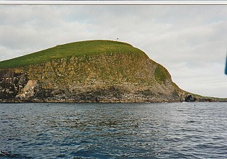
Rona is a remote, uninhabited Scottish island in the North Atlantic. Rona is often referred to as North Rona to distinguish it from South Rona. It has an area of 109 hectares and a maximum elevation of 108 metres (354 ft). It is included within the historic county of Ross-shire.

Rona, sometimes called South Rona to distinguish it from North Rona, is a small inhabited island in the Scottish Inner Hebrides. It lies between the Sound of Raasay and the Inner Sound just north of the neighbouring island of Raasay and east of the Trotternish peninsula of Skye. It has a total area of 930 hectares (3.6 sq mi) and a population of 3.

Graemsay is an island in the western approaches to Scapa Flow, in the Orkney Islands of Scotland. The island has two lighthouses. Graemsay lies within the parish of Stromness.
The Flannan Isles or alternatively, the Seven Hunters are a small island group in the Outer Hebrides of Scotland, approximately 32 kilometres (20 mi) west of the Isle of Lewis. They may take their name from Saint Flannan, the 7th century Irish preacher and abbot.

The Mull of Galloway is the southernmost point of Scotland. It is situated in Wigtownshire, Dumfries and Galloway, at the end of the Rhins of Galloway peninsula.
The Minch, also called North Minch, is a strait in north-west Scotland, separating the north-west Highlands and the northern Inner Hebrides from Lewis and Harris in the Outer Hebrides. It was known as Skotlandsfjörð in Old Norse.

The Butt of Lewis is the most northerly point of Lewis in the Outer Hebrides. The headland, which lies in the North Atlantic, is frequently battered by heavy swells and storms and is marked by the Butt of Lewis Lighthouse. The nearest populated area is the village of Eoropie, about 1 mile to the south.
Lady Isle is a small, uninhabited island, in the Firth of Clyde, Scotland. It was once home to a chapel dedicated to Saint Mary. The island features a lighthouse and a freshwater spring.

Chanonry Point lies at the end of Chanonry Ness, a spit of land extending into the Moray Firth between Fortrose and Rosemarkie on the Black Isle, Scotland.

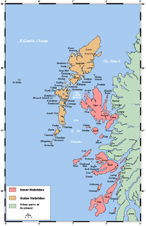
The Hebrides were settled early on in the settlement of the British Isles, perhaps as early as the Mesolithic era, around 8500–8250 BC, after the climatic conditions improved enough to sustain human settlement. There are examples of structures possibly dating from up to 3000 BC, the finest example being the standing stones at Callanish, but some archaeologists date the site as Bronze Age. Little is known of the people who settled in the Hebrides but they were likely of the same Celtic stock that had settled in the rest of Scotland. Settlements at Northton, Harris, have both Beaker & Neolithic dwelling houses, the oldest in the Western Isles, attesting to the settlement.

Shillay is the westernmost of the Monach Islands (Heisgeir), off North Uist in the Outer Hebrides.

Haskeir, also known as Great Haskeir is a remote, exposed and uninhabited island in the Outer Hebrides of Scotland. It lies 13 kilometres west-northwest of North Uist. 1 km southwest lie the skerries of Haskeir Eagach, made up of a colonnade of five rock stacks, and 40 km (25 mi) northwest is St Kilda.

Eilean Glas Lighthouse is situated on the east coast of the island of Scalpay in the Outer Hebrides of Scotland. It was one of the original four lights commissioned by the Commissioners of the Northern Lights, and the first in the Hebrides. These lighthouses were built by Thomas Smith.

Neist Point Lighthouse is a lighthouse located on Neist Point on the Isle of Skye in Scotland. It was designed by David Alan Stevenson and was first lit on 1 November 1909. An aerial cableway is used to take supplies to the lighthouse and cottages.

Barra Head Lighthouse on Barra Head identifies the southern entrance to The Minch, roughly halfway between the Eilean Glas and Rinns of Islay lighthouses. The 58-foot (18-metre) stone tower, built in 1833, stands on the west side of the island, at the top of a very steep cliff, making the light the highest in the UK with a focal plane of 208 m (682 ft) above sea level. It has a range of 18 nautical miles. There is no shallow water west of Berneray to break the blow of the Atlantic storms and small fish are sometimes thrown onto the grass on the cliff top. In 1836 Sir Archibald Geikie recorded the movement of a 42-long-ton (43-tonne) block of gneiss across 5 feet (1.5 m) of ground during a violent storm.

The Tiumpan Head Lighthouse is an active lighthouse located in Tiumpan Head, Isle of Lewis, Outer Hebrides, Scotland.

The Ushenish Lighthouse is an active lighthouse located in South Uist, Outer Hebrides, Scotland.

Flannan Isles Lighthouse is a lighthouse near the highest point on Eilean Mòr, one of the Flannan Isles in the Outer Hebrides off the west coast of mainland Scotland. It is best known for the mysterious disappearance of its keepers in 1900.
Events from the year 1862 in Scotland.

