List of lighthouses in Scotland

Last updated

Map all coordinates using: OpenStreetMap

This is a list of lighthouses in Scotland . The Northern Lighthouse Board, from which much of the information is derived, [1] are responsible for most lighthouses in Scotland but have handed over responsibility in the major estuaries to the port authorities. Many of the more minor lights are not shown. A lighthouse that is no longer operating is indicated by the date of closure in the operated by column. Where two dates are shown, the lighthouse has been rebuilt.

Contents

Nearly all the lighthouses in this list were designed by and most were built by four generations of one family, including Thomas Smith, who was both the stepfather and father-in-law of Robert Stevenson. Robert's sons and grandsons not only built most of the lights, often under the most appalling of conditions, but pioneered many of the improvements in lighting and signalling that cut down the enormous loss of life in shipping around the coasts of Scotland. [2]

The table may be sorted by any column by clicking on the heading.

Lighthouses

NameImageArea
coordinates
Island / mainlandYear builtDesigned / built byOperated by / closedTower heightFocal heightRange
Ailsa Craig Lighthouse   OOjs UI icon edit-ltr-progressive.svg Ailsa Craig Lighthouse - geograph.org.uk - 1363818.jpg South Ayrshire
55°15′6″N 5°6′24″W
Ailsa Craig 1886 Thomas Stevenson, David A Stevenson Northern Lighthouse Board 11 [3] 18 [4] 17 [4]
Ardnamurchan Lighthouse   OOjs UI icon edit-ltr-progressive.svg Ardnamurchan Lighthouse3.jpg Highland
56°43′38″N 6°13′34″W [5]
mainland1849 Alan Stevenson Northern Lighthouse Board [6] 35 [6] 55 [4] 24 [4]
Auskerry Lighthouse   OOjs UI icon edit-ltr-progressive.svg Auskerry Lighthouse (geograph 2853760).jpg Orkney Islands
59°1′33″N 2°34′20″W [7]
Auskerry 1866 [8] David Stevenson, Thomas Stevenson Northern Lighthouse Board 34 [8] 34 [4] 20 [4]
Barns Ness Lighthouse   OOjs UI icon edit-ltr-progressive.svg Barns Ness lighthouse - geograph.org.uk - 1761800.jpg East Lothian [9]
55°59′14″N 2°26′43″W [10]
mainland1899 David A Stevenson, Charles A Stevenson Deactivated 200537 [11] 36 [11] 10 [11]
Barra Head Lighthouse   OOjs UI icon edit-ltr-progressive.svg Entrance to Dun Sron an Duin, Berneray - geograph.org.uk - 1033042.jpg Outer Hebrides
56°47′7″N 7°39′13″W [12]
Barra Head 1833 [13] Robert Stevenson Northern Lighthouse Board [13] 18 [13] 208 [4] [14] [13] 18 [4] [14] [13]
Bass Rock Lighthouse   OOjs UI icon edit-ltr-progressive.svg Bass Rock Gannets Lighthouse.jpg East Lothian [15]
56°4′36″N 2°38′28″W [15]
Bass Rock 1902 David Stevenson Northern Lighthouse Board 20 [16] 46 [14] 10 [14]
Bell Rock Lighthouse   OOjs UI icon edit-ltr-progressive.svg Bell Rock Lighthouse 01.jpg Angus
56°25′58″N 2°23′17″W [17]
Inchcape 1810 Robert Stevenson Northern Lighthouse Board 36 [18] 28 [4] 18 [4]
Bressay Lighthouse   OOjs UI icon edit-ltr-progressive.svg Bressay Lighthouse b 2009 06.JPG Shetland Islands
60°7′12″N 1°7′17″W [19]
Bressay 1858 David Stevenson, Thomas Stevenson Northern Lighthouse Board [20] (until Sep 2012), Lerwick Port Authority (from 2012)16 [20] 32 [20] 23 [20] , 10 [20]
Brough of Birsay Lighthouse   OOjs UI icon edit-ltr-progressive.svg Brough Head Lighthouse - geograph.org.uk - 33197.jpg Orkney Islands
59°8′13″N 3°20′21″W
Brough of Birsay 1925 [21] David A Stevenson Northern Lighthouse Board [21] 11 [21] 52 [4] [21] 18 [4] [21]
Buchan Ness Lighthouse   OOjs UI icon edit-ltr-progressive.svg Buchan Ness Lighthouse, Boddam - geograph.org.uk - 159596.jpg Aberdeenshire
57°28′13″N 1°46′28″W [22]
mainland1827 [23] Robert Stevenson Northern Lighthouse Board 35 [23] 40 [4] 18 [4]
Butt of Lewis Lighthouse   OOjs UI icon edit-ltr-progressive.svg Lighthouse buildings, Butt of Lewis - Rubha Robhanais - geograph.org.uk - 76641.jpg Outer Hebrides
58°30′56″N 6°15′39″W [24]
Isle of Lewis 1862 [25] David Stevenson Northern Lighthouse Board [25] 37 [25] 52 [4] [25] 25 [4] [25]
Cantick Head Lighthouse   OOjs UI icon edit-ltr-progressive.svg Cantick Head Lighthouse 02.jpg Orkney Islands
58°47′14″N 3°7′53″W [26]
South Walls 1858 David Stevenson, Thomas Stevenson Northern Lighthouse Board [27] 22 [27] 35 [27] 13 [14] , 18 [27]
Cape Wrath Lighthouse   OOjs UI icon edit-ltr-progressive.svg Cape Wrath Lighthouse - geograph.org.uk - 821653.jpg Highland
58°37′32″N 4°59′57″W
mainland1828 [28] Robert Stevenson Northern Lighthouse Board [28] 20 [28] 122 [4] 22 [4]
Chanonry Lighthouse   OOjs UI icon edit-ltr-progressive.svg Chanonry Point-Lighthouse-A.JPG Highland, Fortrose [29]
57°34′26″N 4°5′34″W [29]
mainland1846 [30] Alan Stevenson Northern Lighthouse Board 13 [30] 12 [30] 15 [30]
Cloch lighthouse   OOjs UI icon edit-ltr-progressive.svg The Cloch Lighthouse - geograph.org.uk - 721551.jpg Inverclyde
55°56′32″N 4°52′43″W
mainland1797 Thomas Smith, Robert Stevenson Clyde Port Authority 2324 [14] 8 [14]
Copinsay Lighthouse  OOjs UI icon edit-ltr-progressive.svg Copinsay Lighthouse - geograph.org.uk - 253323.jpg Orkney Islands
58°53′47″N 2°40′19″W
Copinsay 1915 David A Stevenson Northern Lighthouse Board [31] 16 [31] 79 [4] 21 [4]
Corran Point Lighthouse   OOjs UI icon edit-ltr-progressive.svg Corran Point Lighthouse.jpg Highland [32]
56°43′15″N 5°14′32″W [32]
mainland1817 Thomas Smith, Robert Stevenson Northern Lighthouse Board [31] 1312 [14] 10 [14] (white), 7 [14] (red green)
Corsewall Lighthouse   OOjs UI icon edit-ltr-progressive.svg Corsewell Lighthouse and Hotel - geograph.org.uk - 1708569.jpg Dumfries and Galloway
55°0′25″N 5°9′33″W [33]
mainland1816 Robert Stevenson Northern Lighthouse Board [34] 34 [34] 3422 [35]
Covesea Skerries Lighthouse   OOjs UI icon edit-ltr-progressive.svg Covesea Lighthouse Lossiemouth.JPG Moray, Lossiemouth and Branderburgh [36]
57°43′27″N 3°20′19″W [36]
mainland1846 Alan Stevenson Northern Lighthouse Board (until 2012)36 [37] 49 [37] 24 [37]
Crammag Head Lighthouse  OOjs UI icon edit-ltr-progressive.svg New lighthouse at Crammag Head geograph - 1867781 - cropped.jpg Dumfries and Galloway
54°39′53″N 4°57′54″W
mainland1913 David A Stevenson Northern Lighthouse Board 735 [4] 18 [4]
Cromarty Lighthouse  OOjs UI icon edit-ltr-progressive.svg Cromarty Lighthouse (geograph 2940092).jpg Highland
57°40′59″N 4°2′11″W [38]
mainland1846 Alan Stevenson Inactive13 [39] 18 [39]
Davaar Lighthouse   OOjs UI icon edit-ltr-progressive.svg Davaar Lighthouse - geograph.org.uk - 1434658.jpg Argyll and Bute
55°25′41″N 5°32′26″W [40]
Island Davaar 1854 [41] David Stevenson, Thomas Stevenson, and John Barr & Co Northern Lighthouse Board 20 [42] 37 [4] 23 [4]
Dubh Artach Lighthouse   OOjs UI icon edit-ltr-progressive.svg Dubh Artach Lighthouse (geograph 4221292).jpg Argyll and Bute
56°7′59″N 6°37′58″W [43]
Dubh Artach 1872 [44] Thomas Stevenson Northern Lighthouse Board 38 [44] 44 [4] [44] 20 [4] [44]
Duncansby Head Lighthouse   OOjs UI icon edit-ltr-progressive.svg Duncansby Head, the lighthouse - geograph.org.uk - 596863.jpg Highland
58°38′38″N 3°1′31″W
mainland1924 David A Stevenson Northern Lighthouse Board 1167 [14] 22 [14]
Dunnet Head Lighthouse   OOjs UI icon edit-ltr-progressive.svg Dunnet Head Lighthouse - geograph.org.uk - 902815.jpg Highland
58°40′17″N 3°22′35″W [45]
mainland1831 [46] Robert Stevenson Northern Lighthouse Board [46] 20 [46] 105 [4] 23 [4]
Eilean Glas Lighthouse   OOjs UI icon edit-ltr-progressive.svg Eilean Glas lighthouse Scalpay - geograph.org.uk - 52874.jpg Outer Hebrides
57°51′25″N 6°38′31″W [47]
Scalpay 1789 [48] Thomas Smith Northern Lighthouse Board [48] 30 [48] 43 [4] [48] 23 [4] [48]
Elie Ness Lighthouse  OOjs UI icon edit-ltr-progressive.svg Elie Ness Lighthouse - geograph.org.uk - 480917.jpg Fife [49]
56°11′2″N 2°48′46″W [49]
mainland1908James Laurie Forth Ports [50] 1115 [14] [51] 17 [14]
Esha Ness Lighthouse   OOjs UI icon edit-ltr-progressive.svg Esha Ness Lighthouse 2017 01.jpg Shetland Islands
60°29′21″N 1°37′38″W [52]
Mainland 1925 David A Stevenson Northern Lighthouse Board 12 [53] 6125 [4]
Fair Isle North Lighthouse  OOjs UI icon edit-ltr-progressive.svg Fair Isle North lighthouse from the fog horn (geograph 4311594).jpg Shetland Islands
59°33′8″N 1°36′35″W [54]
Fair Isle 1892 [55] David A Stevenson, Charles A Stevenson Northern Lighthouse Board 14 [55] 80 [4] 22 [4]
South Lighthouse  OOjs UI icon edit-ltr-progressive.svg Fair Isle South light - geograph.org.uk - 259309.jpg Shetland Islands
59°30′50″N 1°39′10″W [56]
Fair Isle 1892 [57] David A Stevenson, Charles A Stevenson Northern Lighthouse Board 26 [57] 32 [4] 22 [4]
Fidra Lighthouse   OOjs UI icon edit-ltr-progressive.svg FidraLighthouse.JPG East Lothian [58]
56°4′24″N 2°47′6″W [58]
Fidra 1885 [50] David A Stevenson, Thomas Stevenson Forth Ports [50] 17 [50] 34 [4] 15 [4]
Fife Ness Lighthouse   OOjs UI icon edit-ltr-progressive.svg Fife Ness Lighthouse - geograph.org.uk - 937536.jpg Fife
56°16′44″N 2°35′9″W
mainland1975 [59] Peter H. Hyslop [60] Northern Lighthouse Board [59] 5 [59] 12 [4] [59] 21 [4] [59] (white), 20 [4] [59] (red)
Firths Voe Lighthouse  OOjs UI icon edit-ltr-progressive.svg Firths Voe lighthouse, Mossbank.jpg Shetland Islands [61] , Delting [61]
60°27′13″N 1°10′37″W [61]
Mainland 1909 David A Stevenson Northern Lighthouse Board 9915 (white), 10 (green), 10 (red)
Flannan Isles Lighthouse   OOjs UI icon edit-ltr-progressive.svg St. Flannan's Cell and Flannan Isles Lighthouse - geograph.org.uk - 623920.jpg Outer Hebrides
58°17′18″N 7°35′17″W [62]
Eilean Mòr1899 [63] David A Stevenson Northern Lighthouse Board [64] 23 [64] 101 [4] [64] 20 [4] [64]
Foula Lighthouse  OOjs UI icon edit-ltr-progressive.svg Foula Lighthouse (geograph 5027735).jpg Shetland Islands
60°6′45″N 2°3′50″W
Foula 1986 [65] James Johnson Northern Lighthouse Board 836 [65] 18 [65]
Girdleness Lighthouse   OOjs UI icon edit-ltr-progressive.svg Girdle Ness Lighthouse (13795233863).jpg Aberdeen
57°8′20″N 2°2′55″W [66]
mainland1833 [67] Robert Stevenson Northern Lighthouse Board [68] 37 [68] 56 [4] [14] 22 [4] [14]
Holburn Head Lighthouse   OOjs UI icon edit-ltr-progressive.svg HolburnHead.jpg Highland [69] , Thurso [70]
58°36′53″N 3°32′22″W [70]
mainland1862 [71] David Stevenson, Thomas Stevenson Deactivated 200317 [71] 23 [71] 15 [71]
Holy Isle Inner Lighthouse  OOjs UI icon edit-ltr-progressive.svg Lighthouse, Holy Island, Arran - geograph.org.uk - 185791.jpg North Ayrshire
55°30′44″N 5°4′13″W
Holy Island 1877 Thomas Stevenson, David Stevenson Northern Lighthouse Board 1714 [4] 6 [4]
Holy Isle Outer Lighthouse  OOjs UI icon edit-ltr-progressive.svg Lighthouse Holy Isle SE.jpg North Ayrshire
55°31′2″N 5°3′39″W
Holy Island 1905 Thomas Stevenson, David Stevenson Northern Lighthouse Board 2338 [4] 25 [4]
Hoxa Head Lighthouse  OOjs UI icon edit-ltr-progressive.svg Hoxa Head from the Ferry - geograph.org.uk - 931801.jpg Orkney Islands
58°49′19″N 3°2′5″W
South Ronaldsay 1901 [lower-alpha 1] David A Stevenson Northern Lighthouse Board
Hoxa Head Lighthouse  OOjs UI icon edit-ltr-progressive.svg Modern lighthouse and older defences above Scarf Skerry (geograph 3701125).jpg Orkney Islands
58°49′19″N 3°2′5″W
South Ronaldsay 1996 Northern Lighthouse Board 715 [4] 9 [4] (white), 6 [4] (red)
Hoy Sound High Light   OOjs UI icon edit-ltr-progressive.svg Graemsay Hoy High - geograph.org.uk - 1468511.jpg Orkney Islands
58°56′8″N 3°16′23″W
Graemsay 1851 [67] Alan Stevenson Northern Lighthouse Board 3335 [14] 20 [72] (white), 16 [72] (red)
Hoy Sound Low Light   OOjs UI icon edit-ltr-progressive.svg Graemsay Hoy Low - geograph.org.uk - 1466662.jpg Orkney Islands [73]
58°56′25″N 3°18′36″W [73]
Graemsay 1851 [67] Alan Stevenson Northern Lighthouse Board 1217 [14] 12 [14]
Hyskeir Lighthouse   OOjs UI icon edit-ltr-progressive.svg Oigh Sgier - geograph.org.uk - 119673.jpg Highland
56°58′8″N 6°40′51″W
Hyskeir 1904 [74] David A Stevenson, Charles A Stevenson Northern Lighthouse Board [74] 39 [74] 41 [4] [14] 24 [4] [14]
Inchkeith Lighthouse   OOjs UI icon edit-ltr-progressive.svg Inchkeith Lighthouse, Firth of Forth - geograph.org.uk - 924165.jpg Fife
56°2′1″N 3°8′10″W [75]
Inchkeith 1804 [76] Thomas Smith, Robert Stevenson Forth Ports [76] (from Jun 2013), Northern Lighthouse Board [76] (from 1804 until Jun 2013)19 [76] 67 [14] 14 [14]
Isle of May Lighthouse   OOjs UI icon edit-ltr-progressive.svg Isle of May Stevenson Lighthouse.jpg Fife [77]
56°11′8″N 2°33′27″W [78]
Isle of May 1816 [79] Robert Stevenson Northern Lighthouse Board [79] 24 [79] 73 [4] 22 [4]
Isle of May Low Light  OOjs UI icon edit-ltr-progressive.svg Isle of May Low Light.jpg Fife
56°10′59″N 2°33′7″W
Isle of May 1843
Old Isle of May Lighthouse  OOjs UI icon edit-ltr-progressive.svg May Isle first lighthouse - geograph.org.uk - 363015.jpg Fife [80]
56°11′9″N 2°33′24″W [81]
Isle of May 1635 [82] James Maxwell, 1st Earl of Dirletoun
Killantringan Lighthouse   OOjs UI icon edit-ltr-progressive.svg Black Head, Killantringan Lighthouse (geograph 5072618).jpg Dumfries and Galloway
54°51′42″N 5°8′49″W [83]
mainland1900 [84] David A Stevenson Deactivated 200722 [84] 49 [84] 25 [84]
New Kinnaird Head Lighthouse  OOjs UI icon edit-ltr-progressive.svg New Kinnaird Head Lighthouse.jpg Aberdeenshire
57°41′53″N 2°0′15″W [51]
mainland1991 Northern Lighthouse Board 102522
Kinnaird Head Lighthouse  OOjs UI icon edit-ltr-progressive.svg Kinnaird Head Castle Lighthouse 20110520.jpg Aberdeenshire
57°41′51″N 2°0′14″W [85] [86] [87] [88] [89] [90]
mainland1787 Thomas Smith Northern Lighthouse Board (from 1787 until 1991), Museum of Scottish Lighthouses (from 1991)22
Lady Isle Lighthouse   OOjs UI icon edit-ltr-progressive.svg Ladyisleayrshire6.jpg South Ayrshire
55°31′38″N 4°44′2″W [51]
Lady Isle 1903 David A Stevenson Northern Lighthouse Board 1519 [14] 11 [14]
Lismore Lighthouse   OOjs UI icon edit-ltr-progressive.svg Impressive lighthouse (105180429).jpg Argyll and Bute
56°27′20″N 5°36′27″W [91]
Eilean Musdile 1833 Robert Stevenson Northern Lighthouse Board 26 [92] 31 [4] 17 [4]
Little Cumbrae Old Lighthouse  OOjs UI icon edit-ltr-progressive.svg Wee Cumbrae Lighthouse (old) (geograph 4844872).jpg North Ayrshire [93]
55°43′15″N 4°57′29″W [94]
Little Cumbrae Island 1757James Ewing
Cumbrae Lighthouse   OOjs UI icon edit-ltr-progressive.svg Cumbrae Lighthouse (geograph 4536859).jpg North Ayrshire
55°43′16″N 4°58′1″W [95]
Little Cumbrae Island 1793 Thomas Smith Northern Lighthouse Board
Little Cumbrae New Lighthouse  OOjs UI icon edit-ltr-progressive.svg Generator and newest Cumbrae Lighthouse (geograph 2190666).jpg North Ayrshire
55°43′14″N 4°58′2″W
Little Cumbrae Island 1997 Clyde Port Authority 28 [14] 14 [14]
Little Ross lighthouse   OOjs UI icon edit-ltr-progressive.svg Little Ross Lighthouse tower and keepers houses (geograph 2123471).jpg Dumfries and Galloway
54°45′57″N 4°5′6″W [96]
Little Ross 1843 Alan Stevenson Northern Lighthouse Board 2250 [4] 12 [4]
Lother Rock Light  OOjs UI icon edit-ltr-progressive.svg Orkney Islands
58°43′48″N 2°58′42″W
Lother Rock1910 David A Stevenson Northern Lighthouse Board 12136
Old Monach Lighthouse   OOjs UI icon edit-ltr-progressive.svg Shillaylighthouses.jpg Outer Hebrides
57°31′33″N 7°41′46″W
Shillay 1864 Thomas Stevenson, David Stevenson Northern Lighthouse Board 41 [97] 47 [4] 18 [4]
New Monach Light  OOjs UI icon edit-ltr-progressive.svg Shillaylighthouses.jpg Outer Hebrides
57°31′33″N 7°41′44″W
Shillay 1997 Northern Lighthouse Board 5.5 [98] 10
Muckle Flugga Lighthouse   OOjs UI icon edit-ltr-progressive.svg Muckle Fulga Sunny (cropped).jpg Shetland Islands
60°51′19″N 0°53′7″W [99]
Muckle Flugga Thomas Stevenson, David Stevenson Northern Lighthouse Board 20 [100] 66 [4] 22 [4]
Mull of Galloway Lighthouse   OOjs UI icon edit-ltr-progressive.svg Mull of Galloway - lighthouse.jpg Dumfries and Galloway [101]
54°38′6″N 4°51′26″W [102]
mainland1830 Robert Stevenson Northern Lighthouse Board 26 [103] 99 [4] 28 [4]
Mull of Kintyre Lighthouse   OOjs UI icon edit-ltr-progressive.svg Mull of Kintyre Lighthouse. - geograph.org.uk - 347240.jpg Argyll and Bute
55°18′38″N 5°48′12″W [104]
mainland1788 [105] Thomas Smith Northern Lighthouse Board 12 [105] 91 [4] 24 [4]
Neist Point Lighthouse   OOjs UI icon edit-ltr-progressive.svg Neist Point lighthouse - geograph.org.uk - 1204357.jpg Highland
57°25′24″N 6°47′18″W [106] [107]
Duirinish peninsula 1909 [108] David A Stevenson Northern Lighthouse Board [108] 19 [108] 43 [4] [14] [108] 16 [4] [14] [108]
North Rona Lighthouse  OOjs UI icon edit-ltr-progressive.svg North Rona - geograph.org.uk - 854812.jpg Outer Hebrides
59°7′17″N 5°48′53″W
North Rona 1984 Northern Lighthouse Board 13114 [14] 22 [14]
North Ronaldsay Lighthouse   OOjs UI icon edit-ltr-progressive.svg North Ronaldsay Lighthouse - geograph.org.uk - 1759322.jpg Orkney Islands [109]
59°23′23″N 2°22′53″W [110]
North Ronaldsay 1852 Alan Stevenson Northern Lighthouse Board 42 [111] 43 [4] 24 [4]
Dennis Head Old Beacon   OOjs UI icon edit-ltr-progressive.svg The Old Beacon - geograph.org.uk - 1759314.jpg Orkney Islands [112]
59°23′3″N 2°22′17″W [113]
North Ronaldsay 1789 [114] Thomas Smith, Robert Stevenson 21
Noss Head Lighthouse   OOjs UI icon edit-ltr-progressive.svg Noss Head Lighthouse (geograph 2595409).jpg Highland
58°28′44″N 3°3′3″W [115]
mainland1849 [116] Alan Stevenson Northern Lighthouse Board [116] 18 [116] 53 [4] 25 [4] (white), 21 [4] (red)
Noup Head Lighthouse   OOjs UI icon edit-ltr-progressive.svg NoupHeadLighthouse.jpg Orkney Islands
59°19′52″N 3°4′13″W [117]
Westray 1898 [118] David A Stevenson, Charles A Stevenson Northern Lighthouse Board [118] 24 [118] 7922
Ornsay Lighthouse  OOjs UI icon edit-ltr-progressive.svg Ornsay Lighthouse - geograph.org.uk - 541396.jpg Highland
57°8′36″N 5°46′52″W [119]
Ornsay 1857 [120] Thomas Stevenson, David Stevenson Northern Lighthouse Board 19 [120] 18 [14] 12 [14]
Bound Skerry Lighthouse  OOjs UI icon edit-ltr-progressive.svg Bound Skerry Lighthouse - geograph.org.uk - 1409555.jpg Shetland Islands
60°25′28″N 0°43′41″W [121]
Bound Skerry 1858 [122] David Stevenson, Thomas Stevenson Northern Lighthouse Board 30 [122] 44 [4] 20 [4]
Oxcars Lighthouse  OOjs UI icon edit-ltr-progressive.svg Oxcars Lighthouse - geograph.org.uk - 1318731.jpg Fife [123]
56°1′21″N 3°16′49″W [124]
rock1886 [125] David A Stevenson, Thomas Stevenson Forth Ports 221613
Pentland Skerries High Light  OOjs UI icon edit-ltr-progressive.svg Muckle Skerry Lighthouse - geograph.org.uk - 754955.jpg Orkney Islands
58°41′25″N 2°55′29″W
Muckle Skerry 1794 Thomas Smith, Robert Stevenson Northern Lighthouse Board [126] 36 [126] 52 [126] [14] 23 [126] [14]
Pladda Lighthouse   OOjs UI icon edit-ltr-progressive.svg Taighsolaisairpladaigh.jpg North Ayrshire
55°25′30″N 5°7′6″W
Pladda 1790 [127] Thomas Smith Northern Lighthouse Board 29 [127] 40 [4] 17 [4]
Fethaland Lighthouse  OOjs UI icon edit-ltr-progressive.svg The Point of Fethaland light (geograph 5810372).jpg Shetland Islands
60°38′3″N 1°18′41″W
Mainland 1977 Northern Lighthouse Board 76719 [14] (white), 15 (red)
Point of Sleat Lighthouse   OOjs UI icon edit-ltr-progressive.svg Point of Sleat lighthouse - geograph.org.uk - 103213.jpg Highland
57°1′6″N 6°1′3″W
Isle of Skye 2003 Northern Lighthouse Board 520 [14] 9 [14]
Rattray Head lighthouse   OOjs UI icon edit-ltr-progressive.svg Rattray Head Lighthouse - geograph.org.uk - 195991.jpg Aberdeenshire
57°36′36″N 1°48′59″W [128]
rock with causeway1895 [129] David A Stevenson, Charles A Stevenson Northern Lighthouse Board 34 [129] 28 [4] 18 [4]
Rinns of Islay Lighthouse  OOjs UI icon edit-ltr-progressive.svg Orsay Lighthouse - geograph.org.uk - 1101355.jpg Argyll and Bute
55°40′23″N 6°30′48″W [130]
Orsay 1825 [131] Robert Stevenson Northern Lighthouse Board 29 [131] 46 [4] 24 [4]
Rona Lighthouse  OOjs UI icon edit-ltr-progressive.svg Lighthouse, South Rona - geograph.org.uk - 718080.jpg Highland
57°34′41″N 5°57′33″W [132]
South Rona 1857 [133] David Stevenson, Thomas Stevenson Northern Lighthouse Board [133] 13 [133] 69 [4] [133] 19 [4] [133]
Rua Reidh Lighthouse   OOjs UI icon edit-ltr-progressive.svg Rua-reidh.jpg Highland
57°51′32″N 5°48′43″W [134]
mainland1912 [135] [136] David A Stevenson Northern Lighthouse Board [135] 25 [135] 37 [4] [135] 24 [4] [135]
Rubha nan Gall Lighthouse   OOjs UI icon edit-ltr-progressive.svg Rubha nan Gall lighthouse.jpg Argyll and Bute [137]
56°38′19″N 6°3′58″W [137]
Isle of Mull 1857 Thomas Stevenson, David Stevenson Northern Lighthouse Board 1917 [4] 15 [4]
Ruvaal Lighthouse   OOjs UI icon edit-ltr-progressive.svg Rubh a' Mhail Lighthouse (3919995235).jpg Argyll and Bute [138] , Killarow and Kilmeny [139] [140]
55°56′11″N 6°7′25″W [139] [140]
Islay 1859 [141] David Stevenson, Thomas Stevenson Northern Lighthouse Board 34 [141] 45 [4] 19 [4]
Sanda Island Lighthouse   OOjs UI icon edit-ltr-progressive.svg Sanda Island Lighthouse - geograph.org.uk - 56803.jpg Argyll and Bute
55°16′29″N 5°34′58″W
Sanda Island 1850 [142] Alan Stevenson Northern Lighthouse Board [142] 15 [142] 50 [4] 15 [4]
Scarinish Lighthouse  OOjs UI icon edit-ltr-progressive.svg Beach near Scarinish - geograph.org.uk - 315866.jpg Argyll and Bute
56°30′1″N 6°48′15″W
Tiree 1897 David A Stevenson Northern Lighthouse Board 3.51112
Scurdie Ness Lighthouse   OOjs UI icon edit-ltr-progressive.svg Scurdie Ness Lighthouse.jpg Angus
56°42′6″N 2°26′14″W [143]
mainland1870 [67] David Stevenson Northern Lighthouse Board 39 [144] 38 [4] 23 [4]
Skerryvore Lighthouse   OOjs UI icon edit-ltr-progressive.svg Skerryvore 01.jpg Argyll and Bute
56°19′23″N 7°6′58″W [145]
Skerryvore 1844 [146] Alan Stevenson Northern Lighthouse Board [146] 48 [146] 46 [4] 23 [4]
Southerness Lighthouse   OOjs UI icon edit-ltr-progressive.svg Southerness Lighthouse - panoramio (3).jpg Dumfries and Galloway
54°52′22″N 3°35′43″W [147]
mainland1749 [lower-alpha 2] Deactivated in 1931.1017
St. Abbs Lighthouse   OOjs UI icon edit-ltr-progressive.svg St Abbs Lighthouse - geograph.org.uk - 597093.jpg Scottish Borders
55°54′58″N 2°8′20″W [148]
mainland1862 [149] Alan Stevenson, David Stevenson Northern Lighthouse Board 9 [150] 68 [4] 26 [4]
Start Point Lighthouse   OOjs UI icon edit-ltr-progressive.svg Start Point Lighthouse 2, Sanday, Orkney (6266811565).jpg Orkney Islands
59°16′39″N 2°22′33″W [151]
Sanday 1806 [152] Robert Stevenson Northern Lighthouse Board 25 [152] 24 [14] 18 [14]
Stoer Head Lighthouse   OOjs UI icon edit-ltr-progressive.svg Stoer Head Lighthouse.jpg Highland
58°14′24″N 5°24′9″W [153]
mainland1870 [154] Thomas Stevenson, David Stevenson National Trust for Scotland, Northern Lighthouse Board 14 [154] 59 [4] 24 [4]
Strathy Point Lighthouse   OOjs UI icon edit-ltr-progressive.svg The Light House at Strathy Point - geograph.org.uk - 84271.jpg Highland
58°35′55″N 4°1′7″W [51]
mainland1958 [155] Peter H. Hyslop [156] Northern Lighthouse Board (until 2012)14 [155] 4526
Stroma Lighthouse   OOjs UI icon edit-ltr-progressive.svg Stromalighthouse.jpg Highland
58°41′45″N 3°7′0″W [51]
Island of Stroma 1890 Charles A Stevenson, David A Stevenson Northern Lighthouse Board [157] 23 [157] 32 [14] 20 [14] [157]
Sule Skerry Lighthouse   OOjs UI icon edit-ltr-progressive.svg The lighthouse on Sule Skerry (geograph 6164846).jpg Orkney Islands
59°5′3″N 4°24′24″W [158]
Sule Skerry 1895 [159] David A Stevenson, Charles A Stevenson Northern Lighthouse Board [159] 27 [159] 34 [14] 21 [4]
Sumburgh Head Lighthouse   OOjs UI icon edit-ltr-progressive.svg Sumburgh Head lighthouse - geograph.org.uk - 960856.jpg Shetland Islands
59°51′14″N 1°16′29″W
Mainland 1821 [160] Robert Stevenson Northern Lighthouse Board 17 [160] 91 [4] 23 [4]
Tarbat Ness Lighthouse   OOjs UI icon edit-ltr-progressive.svg Tarbat Ness Lighthouse - geograph.org.uk - 501600.jpg Highland [161]
57°51′54″N 3°46′36″W [161]
mainland1830 [162] Robert Stevenson Northern Lighthouse Board 41 [162] 53 [4] 24 [4]
Tiumpan Head Lighthouse   OOjs UI icon edit-ltr-progressive.svg PortvolleVillage (1).jpg Outer Hebrides [163]
58°15′40″N 6°8′20″W [163]
Isle of Lewis 1900 [164] David A Stevenson, Charles A Stevenson Northern Lighthouse Board 21 [164] 55 [4] 25 [4]
Todhead Lighthouse  OOjs UI icon edit-ltr-progressive.svg Todhead Point Lighthouse (13795090983).jpg Aberdeenshire
56°53′2″N 2°12′55″W [165]
mainland1897 [166] David A Stevenson Northern Lighthouse Board (until 2007)1341 [166] 18 [166]
Tor Ness Lighthouse  OOjs UI icon edit-ltr-progressive.svg Tor Ness Lighthouse (A3600) - geograph.org.uk - 1532519.jpg Orkney Islands
58°46′43″N 3°17′47″W
Hoy 1980 [167] John Smith Northern Lighthouse Board 821 [14] 17 [14]
Toward Point Lighthouse   OOjs UI icon edit-ltr-progressive.svg Lighthouse at Toward Point - geograph.org.uk - 1199079.jpg Argyll and Bute
55°51′44″N 4°58′47″W [168]
mainland1812 Robert Stevenson Clyde Port Authority 1921 [4] [14] 22 [4] [14]
Turnberry Lighthouse   OOjs UI icon edit-ltr-progressive.svg TURNBERRY LIGHTHOUSE (3041342571).jpg South Ayrshire [169] , Kirkoswald [170]
55°19′33″N 4°50′41″W [170]
mainland1873 [171] David Stevenson, Thomas Stevenson Northern Lighthouse Board 2429 [4] [171] 24 [4] [171]
Ushenish Lighthouse   OOjs UI icon edit-ltr-progressive.svg Uisinis Lighthouse, South Uist - geograph.org.uk - 203316.jpg Outer Hebrides
57°17′54″N 7°11′35″W
South Uist 1857 [172] Thomas Stevenson, David Stevenson Northern Lighthouse Board [172] 12 [172] 54 [4] 19 [4] (white), 15 [4] (red)
Vaternish Lighthouse   OOjs UI icon edit-ltr-progressive.svg Lighthouse, Waternish Point - geograph.org.uk - 88062.jpg Highland
57°36′29″N 6°38′3″W [173]
Isle of Skye 1980 [173] Northern Lighthouse Board 721 [14] 8 [14]
Vaternish Point Lighthouse  OOjs UI icon edit-ltr-progressive.svg Highland
57°36′29″N 6°38′3″W [173]
Isle of Skye 1924John Smith Northern Lighthouse Board
Weavers Point Lighthouse  OOjs UI icon edit-ltr-progressive.svg Madadh Beag.jpg Outer Hebrides
57°36′30″N 7°6′0″W [174]
North Uist 1980 [174] John Smith Northern Lighthouse Board 424 [14] 7 [14]

See also

Notes

  1. Replaced with modern lighthouse in 1996.
  2. Built in 1748 but not lit till 1800. Rebuilt in 1844.

Related Research Articles

<span class="mw-page-title-main">Robert Stevenson (civil engineer)</span> Civil engineer and lighthouse designer (1772–1850)

Robert Stevenson, FRSE, FGS, FRAS, FSA Scot, MWS was a Scottish civil engineer, and designer and builder of lighthouses. His works include the Bell Rock Lighthouse.

<span class="mw-page-title-main">Charles Alexander Stevenson</span> Scottish engineer

Charles Alexander Stevenson MICE MIEE FRSE was a Scottish lighthouse engineer who built twenty-three lighthouses in and around Scotland.

Holborn Head is a headland on the north-facing Atlantic coast of Caithness, in the Highland area of Scotland. The point of Holborn Head is at 58°37′23″N03°32′06″W. It has a lighthouse at its south end and the remains of an old fort at its tip.

<span class="mw-page-title-main">Butt of Lewis</span>

The Butt of Lewis is the most northerly point of Lewis in the Outer Hebrides. The headland, which lies in the North Atlantic, is frequently battered by heavy swells and storms and is marked by the Butt of Lewis Lighthouse. The nearest populated area is the village of Eoropie, about 1 mile to the south.

<span class="mw-page-title-main">Elcho Castle</span> Castle in Perth and Kinross, Scotland, UK

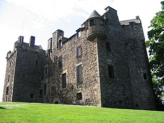
Elcho Castle is located close to the south bank of the River Tay approximately four miles south-east of Perth, Scotland, in the region of Perth and Kinross. It was maintained by Clan Wemyss from its construction around 1560 until it was put into the care of the Secretary of State for Scotland in the early 20th century, though was not occupied for the entire time. In around 1830 it was re-roofed and a nearby cottage constructed. The castle has been a scheduled monument since 1920 on the grounds of being "a particularly fine example of a Medieval tower-house", and the cottage became a listed building in 1971 in recognition of its national importance. The castle is unusual in that it has both en suite guest accommodation like a mansion, but also a large number of gun loops.

<span class="mw-page-title-main">Tarbat</span> Human settlement in Scotland

Tarbat is a civil parish in Highland, Scotland, in the north-east corner of Ross and Cromarty.

<span class="mw-page-title-main">Shetland Amenity Trust</span>

The Shetland Amenity Trust is a charitable trust based in Shetland, Scotland. It was formed in 1983.

<span class="mw-page-title-main">Barns Ness Lighthouse</span> Lighthouse 5 km from Dunbar Scotland

Barns Ness Lighthouse is 3.1 miles (5 km) from Dunbar and was constructed by the engineers and brothers David A. Stevenson and Charles Alexander Stevenson, cousins of the novelist Robert Louis Stevenson, between 1899 and 1901. Taking approximately 2½ years to construct, it was constructed from stone quarried from Craigree and Barnton. In 1976 it was described as a tall tower, slightly tapered with a circular section having a circular lantern which has triangular panes and a domed roof. The keepers' cottages were, as is typical, one floored, flat roofed buildings which were coated with harling but had their quoins exposed. The lintel above the door to the lighthouse is dated 1901. Within the compound of the lighthouse there was also a sundial and a flagpole.

<span class="mw-page-title-main">Innerwick</span> Human settlement in Scotland

Innerwick is a coastal civil parish and small village, which lies in the east of East Lothian, five miles from Dunbar and approximately 32 miles from Edinburgh.

<span class="mw-page-title-main">Rendall</span>

Rendall is a parish on Mainland, Orkney, Scotland. It is in the north west of the island and lies east of the parishes of Birsay and Evie and north east of Harray. The island of Gairsay is also in the parish.

<span class="mw-page-title-main">Scurdie Ness</span> Lighthouse

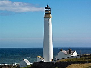
Scurdie Ness is a headland located on the South side of the River South Esk estuary, Montrose, Angus, Scotland. The River leads from the North Sea into Montrose Harbour and then into Montrose Basin. The headland has also been referred to as Scurdy Ness, Montrose point or Montroseness. The word Scurdie is a local word for the volcanic rock found there and Ness means a promontory, cape or headland. The coastline from Scurdie Ness to Rickle Craig has been designated a Site of Special Scientific Interest.

<span class="mw-page-title-main">West End, Edinburgh</span> Human settlement in Scotland

The West End is an affluent district of Edinburgh, Scotland, which along with the rest of the New Town and Old Town forms central Edinburgh, and Edinburgh's UNESCO World Heritage Site. The area boasts several of the city's hotels, restaurants, independent shops, offices and arts venues, including the Edinburgh Filmhouse, Edinburgh International Conference Centre and the Caledonian Hotel. The area also hosts art festivals and crafts fairs.

<span class="mw-page-title-main">Noss Head Lighthouse</span> Lighthouse

The Noss Head Lighthouse is an active 19th-century lighthouse near Wick in Caithness in the Highland council area of Scotland. It is located at the end of Noss Head, a peninsula on the north-west coast of Caithness that overlooks Sinclairs Bay, three miles north-east of Wick. It is notable as being the first lighthouse that was built with a diagonally-paned lantern room.

<span class="mw-page-title-main">Couper Institute Library</span> Building in Cathcart, Glasgow

The Couper Institute Library is a public library situated in Cathcart, Glasgow, Scotland. The Couper Institute was originally built by architects Campbell Douglas and James Sellars. The library was added in 1923 by architect John Alfred Taylor Houston on the bequest of Robert Couper. The institute and its library are now are now listed buildings, category B.

<span class="mw-page-title-main">Girdle Ness Lighthouse</span> Lighthouse in Aberdeen, Scotland

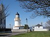
Girdle Ness Lighthouse is situated near Torry Battery on the Girdle Ness peninsula just south of the entrance to Aberdeen's harbour, in Scotland. It is an active light, managed by the Northern Lighthouse Board.

<span class="mw-page-title-main">Statue of Henry Campbell-Bannerman</span> Monument in Stirling, Scotland, UK

A statue of Henry Campbell-Bannerman by Paul Raphael Montford stands in Stirling, Scotland. Erected in 1913, it depicts Henry Campbell-Bannerman, the former Prime Minister of the United Kingdom and Liberal Member of Parliament for Stirling Burghs. It is located on Corn Exchange Road and is close to Stirling railway station. Historic Environment Scotland notes the statue as a listed building.

<span class="mw-page-title-main">Ballone Castle</span> Human settlement in Scotland

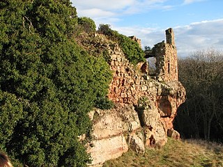
Ballone Castle was built in the 16th century. It was unoccupied for a couple of centuries and fell into ruin. In the 1990s it was purchased and restored by an architect. The original castle was built on a Z-plan and is unusual in having one round tower and one rectangular tower.
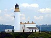
<span class="mw-page-title-main">South Galson</span> Human settlement in Scotland

South Galson is a settlement on the northwest coast of the Isle of Lewis in the Western Isles of Scotland. It is 11 km southwest of Port of Ness. The Galson Primary School closed in 1996. The populations of North Galson, South Galson, and Melbost were 149 in 1999.

Coastal fortifications in Scotland played a vital role during the World Wars, protecting shipping as they mustered to convoy. New fortifications were built and old defences were also rebuilt or strengthened around the Scottish coast in case of invasion. New technologies like Radar were also deployed.

References

  1. "Lighthouse Library". Northern Lighthouse Board. Retrieved 23 June 2015.
  2. Bathurst, Bella (1999). The Lighthouse Stevensons . Harper Collins. p. xvii. ISBN   9780060194277.
  3. http://www.nlb.org.uk/LighthouseLibrary/Lighthouse/Ailsa-Craig/
  4. 1 2 3 4 5 6 7 8 9 10 11 12 13 14 15 16 17 18 19 20 21 22 23 24 25 26 27 28 29 30 31 32 33 34 35 36 37 38 39 40 41 42 43 44 45 46 47 48 49 50 51 52 53 54 55 56 57 58 59 60 61 62 63 64 65 66 67 68 69 70 71 72 73 74 75 76 77 78 79 80 81 82 83 84 85 86 87 88 89 90 91 92 93 94 95 96 97 98 99 100 101 102 103 104 105 106 107 108 109 110 111 112 113 114 Reeds PBO Small Craft Almanac 2014. ISBN   978-1-4081-9330-3. OL   32692860M. Wikidata   Q25198336.
  5. "Listed building details (number=LB521)". Historic Environment Scotland.
  6. 1 2 http://www.nlb.org.uk/LighthouseLibrary/Lighthouse/Ardnamurchan/
  7. "Listed building details (number=LB18638)". Historic Environment Scotland.
  8. 1 2 http://www.nlb.org.uk/LighthouseLibrary/Lighthouse/Auskerry/
  9. http://portal.historicenvironment.scot/designation/LB1465
  10. "Listed building details (number=LB1465)". Historic Environment Scotland.
  11. 1 2 3 http://www.nlb.org.uk/LighthouseLibrary/Lighthouse/Barns-Ness/
  12. "Listed building details (number=LB5893)". Historic Environment Scotland.
  13. 1 2 3 4 5 http://www.nlb.org.uk/LighthouseLibrary/Lighthouse/Barra-Head/
  14. 1 2 3 4 5 6 7 8 9 10 11 12 13 14 15 16 17 18 19 20 21 22 23 24 25 26 27 28 29 30 31 32 33 34 35 36 37 38 39 40 41 42 43 44 45 46 47 48 49 50 51 NGA List of Lights, Radio Aids and Fog Signals, National Geospatial-Intelligence Agency, Wikidata   Q13872896
  15. 1 2 http://portal.historicenvironment.scot/designation/LB14738
  16. http://www.nlb.org.uk/LighthouseLibrary/Lighthouse/Bass-Rock/
  17. "Listed building details (number=LB45197)". Historic Environment Scotland.
  18. http://www.nlb.org.uk/LighthouseLibrary/Lighthouse/Bell-Rock/
  19. "Listed building details (number=LB5882)". Historic Environment Scotland.
  20. 1 2 3 4 5 http://www.nlb.org.uk/LighthouseLibrary/Lighthouse/Bressay/
  21. 1 2 3 4 5 http://www.nlb.org.uk/lighthouselibrary/lighthouse/brough-of-birsay/
  22. "Listed building details (number=LB16367)". Historic Environment Scotland.
  23. 1 2 http://www.nlb.org.uk/LighthouseLibrary/Lighthouse/Buchan-Ness/
  24. "Listed building details (number=LB5768)". Historic Environment Scotland.
  25. 1 2 3 4 5 http://www.nlb.org.uk/LighthouseLibrary/Lighthouse/Butt-of-Lewis/
  26. "Listed building details (number=LB18710)". Historic Environment Scotland.
  27. 1 2 3 4 http://www.nlb.org.uk/LighthouseLibrary/Lighthouse/Cantick-Head/
  28. 1 2 3 http://www.nlb.org.uk/LighthouseLibrary/Lighthouse/Cape-Wrath/
  29. 1 2 "Listed building details (number=LB31799)". Historic Environment Scotland.
  30. 1 2 3 4 http://www.nlb.org.uk/LighthouseLibrary/Lighthouse/Chanonry/
  31. 1 2 3 http://www.nlb.org.uk/LighthouseLibrary/Lighthouse/Copinsay/
  32. 1 2 http://portal.historicenvironment.scot/designation/LB1689
  33. "Listed building details (number=LB9923)". Historic Environment Scotland.
  34. 1 2 http://www.nlb.org.uk/LighthouseLibrary/Lighthouse/Corsewall/
  35. https://www.nlb.org.uk/Lighthouse.aspx?id=597
  36. 1 2 "Listed building details (number=LB37605)". Historic Environment Scotland.
  37. 1 2 3 http://www.nlb.org.uk/LighthouseLibrary/Lighthouse/Covesea/
  38. "Listed building details (number=LB23680)". Historic Environment Scotland.
  39. 1 2 http://www.nlb.org.uk/LighthouseLibrary/Lighthouse/Cromarty/
  40. "Listed building details (number=LB4920)". Historic Environment Scotland.
  41. https://www.nlb.org.uk/LighthouseLibrary/Lighthouse/Davaar/
  42. http://www.scottish-places.info/features/featurefirst19008.html
  43. "Listed building details (number=LB12320)". Historic Environment Scotland.
  44. 1 2 3 4 http://www.nlb.org.uk/LighthouseLibrary/Lighthouse/Dubh-Artach/
  45. "Listed building details (number=LB1890)". Historic Environment Scotland.
  46. 1 2 3 https://www.nlb.org.uk/LighthouseLibrary/Lighthouse/Dunnet-Head/
  47. "Listed building details (number=LB13487)". Historic Environment Scotland.
  48. 1 2 3 4 5 http://www.nlb.org.uk/LighthouseLibrary/Lighthouse/Eilean-Glas/
  49. 1 2 http://portal.historicenvironment.scot/designation/LB8997
  50. 1 2 3 4 https://www.nlb.org.uk/LighthouseLibrary/Lighthouse/Fidra/
  51. 1 2 3 4 5 MarineTraffic, Wikidata   Q18518862
  52. "Listed building details (number=LB44556)". Historic Environment Scotland.
  53. http://www.nlb.org.uk/LighthouseLibrary/Lighthouse/Eshaness/
  54. "Listed building details (number=LB5446)". Historic Environment Scotland.
  55. 1 2 https://www.nlb.org.uk/LighthouseLibrary/Lighthouse/Fair-Isle-North/
  56. "Listed building details (number=LB5411)". Historic Environment Scotland.
  57. 1 2 https://www.nlb.org.uk/LighthouseLibrary/Lighthouse/Fair-Isle-South/
  58. 1 2 http://portal.historicenvironment.scot/designation/LB1336
  59. 1 2 3 4 5 6 https://www.nlb.org.uk/LighthouseLibrary/Lighthouse/Fife-Ness/
  60. https://britishlistedbuildings.co.uk/200407355-fife-ness-lighthouse-crail#.YEXj8Z37RaQ
  61. 1 2 3 http://portal.historicenvironment.scot/designation/LB44532
  62. "Listed building details (number=LB48143)". Historic Environment Scotland.
  63. https://www.nlb.org.uk/LighthouseLibrary/Lighthouse/Flannan-Islands/
  64. 1 2 3 4 http://www.nlb.org.uk/LighthouseLibrary/Lighthouse/Flannan-Islands/
  65. 1 2 3 https://www.nlb.org.uk/LighthouseLibrary/Lighthouse/Foula/
  66. "Listed building details (number=LB20078)". Historic Environment Scotland.
  67. 1 2 3 4 Canmore, Wikidata   Q5032525
  68. 1 2 http://www.nlb.org.uk/LighthouseLibrary/Lighthouse/Girdle-Ness/
  69. http://portal.historicenvironment.scot/designation/LB14952
  70. 1 2 "Listed building details (number=LB14952)". Historic Environment Scotland.
  71. 1 2 3 4 https://www.nlb.org.uk/LighthouseLibrary/Lighthouse/Holburn-Head/
  72. 1 2 http://foghornpublishing.com/Digest/database/uniquelighthouse.cfm?value=1898
  73. 1 2 http://portal.historicenvironment.scot/designation/LB13841
  74. 1 2 3 http://www.nlb.org.uk/LighthouseLibrary/Lighthouse/Hyskeir/
  75. "Listed building details (number=LB9707)". Historic Environment Scotland.
  76. 1 2 3 4 https://www.nlb.org.uk/LighthouseLibrary/Lighthouse/Inchkeith/
  77. http://portal.historicenvironment.scot/designation/LB2712
  78. "Listed building details (number=LB2712)". Historic Environment Scotland.
  79. 1 2 3 http://www.nlb.org.uk/LighthouseLibrary/Lighthouse/Isle-of-May/
  80. http://portal.historicenvironment.scot/designation/SM887
  81. "Listed building details (number=SM887)". Historic Environment Scotland.
  82. "Isle of May Lighthouse".
  83. "Listed building details (number=LB16758)". Historic Environment Scotland.
  84. 1 2 3 4 https://www.nlb.org.uk/LighthouseLibrary/Lighthouse/Killantringan/
  85. "Listed building details (number=LB31888)". Historic Environment Scotland.
  86. "Listed building details (number=LB31888)". Historic Environment Scotland.
  87. "Listed building details (number=LB31888)". Historic Environment Scotland.
  88. "Listed building details (number=LB31888)". Historic Environment Scotland.
  89. "Listed building details (number=LB31888)". Historic Environment Scotland.
  90. "Listed building details (number=LB31888)". Historic Environment Scotland.
  91. "Listed building details (number=LB12360)". Historic Environment Scotland.
  92. https://www.nlb.org.uk/LighthouseLibrary/Lighthouse/Lismore/
  93. http://portal.historicenvironment.scot/designation/SM418
  94. "Listed building details (number=SM418)". Historic Environment Scotland.
  95. "Listed building details (number=LB852)". Historic Environment Scotland.
  96. "Listed building details (number=LB3399)". Historic Environment Scotland.
  97. https://www.nlb.org.uk/LighthouseLibrary/Lighthouse/Monach/
  98. https://www.ibiblio.org/lighthouse/heb.htm
  99. "Listed building details (number=LB17479)". Historic Environment Scotland.
  100. https://www.nlb.org.uk/LighthouseLibrary/Lighthouse/Muckle-Flugga/
  101. http://portal.historicenvironment.scot/designation/LB13578
  102. "Listed building details (number=LB13578)". Historic Environment Scotland.
  103. https://www.nlb.org.uk/LighthouseLibrary/Lighthouse/Mull-of-Galloway/
  104. "Listed building details (number=LB19874)". Historic Environment Scotland.
  105. 1 2 https://www.nlb.org.uk/LighthouseLibrary/Lighthouse/Mull-of-Kintyre/
  106. "Listed building details (number=LB465)". Historic Environment Scotland.
  107. "Listed building details (number=LB465)". Historic Environment Scotland.
  108. 1 2 3 4 5 http://www.nlb.org.uk/LighthouseLibrary/Lighthouse/Neist-Point/
  109. http://portal.historicenvironment.scot/designation/LB5892
  110. "Listed building details (number=LB5892)". Historic Environment Scotland.
  111. https://www.nlb.org.uk/LighthouseLibrary/Lighthouse/North-Ronaldsay/
  112. http://portal.historicenvironment.scot/designation/SM6596
  113. "Listed building details (number=SM6596)". Historic Environment Scotland.
  114. http://hodgers.com/northronaldsay/2006/08/the_old_beacon.shtml
  115. "Listed building details (number=LB14087)". Historic Environment Scotland.
  116. 1 2 3 https://www.nlb.org.uk/LighthouseLibrary/Lighthouse/Noss-Head/
  117. "Listed building details (number=LB18736)". Historic Environment Scotland.
  118. 1 2 3 https://www.nlb.org.uk/LighthouseLibrary/Lighthouse/Noup-Head/
  119. "Listed building details (number=LB14008)". Historic Environment Scotland.
  120. 1 2 https://www.nlb.org.uk/LighthouseLibrary/Lighthouse/Ornsay/
  121. "Listed building details (number=LB19894)". Historic Environment Scotland.
  122. 1 2 https://www.nlb.org.uk/LighthouseLibrary/Lighthouse/Out-Skerries-Lighthouse/
  123. http://portal.historicenvironment.scot/designation/LB49687
  124. "Listed building details (number=LB49687)". Historic Environment Scotland.
  125. Tom Nancollas (2018). Seashaken Houses. ISBN   978-1-84614-938-2. OL   28716637M. Wikidata   Q80678896.
  126. 1 2 3 4 https://www.nlb.org.uk/LighthouseLibrary/Lighthouse/Pentland-Skerries/
  127. 1 2 https://www.nlb.org.uk/LighthouseLibrary/Lighthouse/Pladda/
  128. "Listed building details (number=LB3042)". Historic Environment Scotland.
  129. 1 2 https://www.nlb.org.uk/LighthouseLibrary/Lighthouse/Rattray-Head/
  130. "Listed building details (number=LB11944)". Historic Environment Scotland.
  131. 1 2 https://www.nlb.org.uk/LighthouseLibrary/Lighthouse/Rinns-of-Islay/
  132. "Listed building details (number=LB18449)". Historic Environment Scotland.
  133. 1 2 3 4 5 http://www.nlb.org.uk/LighthouseLibrary/Lighthouse/Rona/
  134. "Listed building details (number=LB49894)". Historic Environment Scotland.
  135. 1 2 3 4 5 http://www.nlb.org.uk/LighthouseLibrary/Lighthouse/Rubh-Re/
  136. https://canmore.org.uk/site/267701/rubha-reidh-lighthouse
  137. 1 2 http://portal.historicenvironment.scot/designation/LB11015
  138. http://portal.historicenvironment.scot/designation/LB12117
  139. 1 2 "Listed building details (number=LB12117)". Historic Environment Scotland.
  140. 1 2 "Listed building details (number=LB12117)". Historic Environment Scotland.
  141. 1 2 https://www.nlb.org.uk/LighthouseLibrary/Lighthouse/Ruvaal/
  142. 1 2 3 http://www.nlb.org.uk/LighthouseLibrary/Lighthouse/Sanda/
  143. "Listed building details (number=LB4958)". Historic Environment Scotland.
  144. http://www.nlb.org.uk/LighthouseLibrary/Lighthouse/Scurdie-Ness/
  145. "Listed building details (number=LB17849)". Historic Environment Scotland.
  146. 1 2 3 http://www.nlb.org.uk/LighthouseLibrary/Lighthouse/Skerryvore/
  147. https://maps.nls.uk/geo/explore/#zoom=16.0&lat=54.87266&lon=-3.59679&layers=6&b=1&marker=54.872823,-3.595180
  148. "Listed building details (number=LB4103)". Historic Environment Scotland.
  149. https://canmore.org.uk/site/78115/st-abbs-head-lighthouse
  150. https://www.nlb.org.uk/LighthouseLibrary/Lighthouse/St--Abbs-Head/
  151. "Listed building details (number=LB12675)". Historic Environment Scotland.
  152. 1 2 https://www.nlb.org.uk/LighthouseLibrary/Lighthouse/Start-Point/
  153. "Listed building details (number=LB1833)". Historic Environment Scotland.
  154. 1 2 https://www.nlb.org.uk/LighthouseLibrary/Lighthouse/Stoer-Head/
  155. 1 2 https://www.nlb.org.uk/LighthouseLibrary/Lighthouse/Strathy-Point/
  156. https://www.google.co.uk/books/edition/The_Last_Lighthouse/sogJ9x2r4EoC
  157. 1 2 3 http://www.nlb.org.uk/LighthouseLibrary/Lighthouse/Stroma/
  158. "Listed building details (number=LB18598)". Historic Environment Scotland.
  159. 1 2 3 http://www.nlb.org.uk/Lighthouse.aspx?id=849
  160. 1 2 https://www.nlb.org.uk/LighthouseLibrary/Lighthouse/Sumburgh-Head/
  161. 1 2 http://portal.historicenvironment.scot/designation/LB14100
  162. 1 2 https://www.nlb.org.uk/LighthouseLibrary/Lighthouse/Tarbat-Ness/
  163. 1 2 http://portal.historicenvironment.scot/designation/LB19209
  164. 1 2 https://www.nlb.org.uk/LighthouseLibrary/Lighthouse/Tiumpan-Head/
  165. "Listed building details (number=LB9535)". Historic Environment Scotland.
  166. 1 2 3 https://www.nlb.org.uk/LighthouseLibrary/Lighthouse/Tod-Head/
  167. https://www.nlb.org.uk/LighthouseLibrary/Lighthouse/Tor-Ness/
  168. "Listed building details (number=LB5070)". Historic Environment Scotland.
  169. http://portal.historicenvironment.scot/designation/LB12991
  170. 1 2 "Listed building details (number=LB12991)". Historic Environment Scotland.
  171. 1 2 3 http://www.nlb.org.uk/LighthouseLibrary/Lighthouse/Turnberry/
  172. 1 2 3 http://www.nlb.org.uk/LighthouseLibrary/Lighthouse/Ushenish/
  173. 1 2 3 https://www.nlb.org.uk/LighthouseLibrary/Lighthouse/Vaternish/
  174. 1 2 https://www.nlb.org.uk/LighthouseLibrary/Lighthouse/Weavers-Point/

Further reading