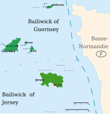
This is a list of lighthouses in the Channel Islands. The archipelago lies to the west of the Cotentin Peninsula in the English Channel. There are lighthouses on all of the four main islands: Alderney, Guernsey, Jersey and Sark. [1] [2] [3]
This is a list of lighthouses in the Channel Islands. The archipelago lies to the west of the Cotentin Peninsula in the English Channel. There are lighthouses on all of the four main islands: Alderney, Guernsey, Jersey and Sark. [1] [2] [3]
| Name | Image | Location & coordinates | Year built | Tower height (in metres) | Focal height ( in metres) | Admiralty number |
|---|---|---|---|---|---|---|
| Alderney Lighthouse |  | Alderney | 1912 | 32 | 37 | A1536 |
| Bréhon Tower |  | Bailiwick of Guernsey | 1856 | 7 | 19 [4] | A1559 |
| Crocq Pierhead lighthouse | | Saint Sampson | 6 | 11 | A1554 | |
| Castle Breakwater Lighthouse |  | Saint Peter Port | 1850s | 12 | 14 | A1560 |
| Casquets lighthouses |  | Alderney | 1724 [5] | 23 [5] | 37 [6] [5] | A1532 |
| Les Hanois Lighthouse |  | Torteval | 1862 [7] | 36 | 33 [6] | A1580 |
| St Martins Point Lighthouse | 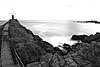 | Jerbourg Point | 5 | 15 | A1574 | |
| Platte Fougère lighthouse |  | Saint Sampson | 1910 | 25 | 25 | A1548 |
| Platte lighthouse | Little Roussel | 6 | 9 | A1550 | ||
| Roustel Beacon | Little Roussel | 1970 | 8 | 10 | A1552 | |
| Sark Lighthouse |  | Point Robert | 1913 | 17 | 65 [6] | A1544 |
| St Sampsons South Pier, Range Rear |  | Saint Sampson | 1874 | 12 | 13 | A1558.1 |
| Tautenay Lighthouse | Herm | 8 | 7 | A1548.5 | ||
| Victoria Marina Lighthouse | Saint Peter Port Harbour | 7 | 10 | A1569 | ||
| White Rock Pier Lighthouse |  | Saint Peter Port Harbour | 1908 | 10 | 11 | A1562 |
| Name | Image | Location & coordinates | Year built | Tower height (in metres) | Focal height (in metres) | Admiralty number |
|---|---|---|---|---|---|---|
| La Corbière Lighthouse |  | La Corbière | 1874 | 19 | 36 [6] | A1620 |
| St. Catherine's Breakwater Lighthouse |  | Saint Martin | 9 | 18 | A1586 | |
| Demie de Pas Lighthouse |  | Saint Helier | 1904 | 13 | 11 | A1598 |
| Gorey Pier Lighthouse |  | Gorey | 1966 | 9 | 8 | A1588 |
| Greve d'Azette Lighthouse |  | Saint Helier | 1896 | 19 | 23 | A1594 |
| La Tour de Vinde |  | Saint Brelade | 1915 | 10 | 18 | A1616 |
| Sorel Point Lighthouse | 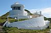 | Saint John | 1938 | 3 | 49.7 | A1584 |
| Mount Ube lighthouse |  | Saint Helier | 1896 | 14 | 46 | A1594.1 |
Lighthouses and lightvessels in Europe | |
|---|---|
| Sovereign states |
|
Dependencies and other territories | |