| Name | Image | Location | Province | Tower height | Light characteristic | Year built | Architect |
|---|
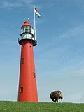
| Urk Lighthouse |  | Urk | Flevoland | 18,5 m (27 m above NAP) | Fl W 5s (18 nautical miles (33 km)) | 1844–1845 | Valk, J. |
| Bornrif |  | Ameland | Friesland | 55,3 m (58 m above NAP) | Fl(3) W 15s (30 nautical miles (56 km)) | 1880–1881 | Harder, Quirinus |
| North Tower | 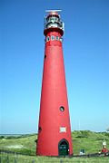 | Schiermonnikoog | Friesland | 37 m (44 m above NAP) | Fl(4) W 20s (28 nautical miles (52 km)) | 1853–1854 | Jansen, H.G. |
| Stavoren Lighthouse |  | Stavoren | Friesland | 15,7 m (15 m above NAP) | Iso W 4s (12 nautical miles (22 km)) | 1884 | Harder, Quirinus |
| Brandaris |  | Terschelling | Friesland | 52,5 m (55 m above NAP) | Fl W 5s (29 nautical miles (54 km)) | 1593–1594 | |
| Vuurduin |  | Vlieland | Friesland | 16,8 m (54 m above NAP) | Iso W 4s (20 nautical miles (37 km)) | 1909 | Harder, Quirinus |
| Lange Jaap |  | Den Helder | North Holland | 55,5 m (57 m above NAP) | Fl(4) W 20s (30 nautical miles (56 km)) | 1877–1878 | Harder, Quirinus |
| Den Oever Lighthouse |  | Den Oever | North Holland | 15 m above NAP | Iso WRG 5s (10 nautical miles (19 km)) | 1884 | Harder, Quirinus |
| J.C.J. van Speijk Lighthouse |  | Egmond aan Zee | North Holland | 28 m (37 m above NAP) | Iso WR 10s (18 nautical miles (33 km)) | 1833–1834 | Valk, J. |
| Hoge vuurtoren van IJmuiden |  | IJmuiden | North Holland | 41,8 m (53 m above NAP) | Fl W 5s (29 nautical miles (54 km)) | 1878 | Harder, Quirinus |
| Lage vuurtoren van IJmuiden | 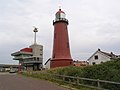 | IJmuiden | North Holland | 24 m (31 m above NAP) | F WR (16 nautical miles (30 km)) | 1878 | Harder, Quirinus |
| Groote Kaap | 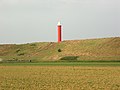 | Julianadorp | North Holland | 16,8 m (31 m above NAP) | Oc WRG 10s (11 nautical miles (20 km)) | 1966 | |
| Paard van Marken |  | Marken | North Holland | 15,5 m (16 m above NAP) | Oc W 8s (9 nautical miles (17 km)) | 1839 | Valk, J. |
| De Ven | 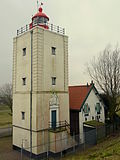 | Oosterdijk | North Holland | 15 m (17 m above NAP) | LFlW10s (11 nautical miles (20 km)) | 1700 | |
| Eierland Lighthouse | 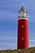 | Texel | North Holland | 34,7 m (53 m above NAP) | Fl(2) W 10s (29 nautical miles (54 km)) | 1863–1864 | Harder, Quirinus |
| Nieuwe Sluis | 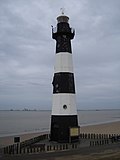 | Breskens | Zeeland | 22,4 m (28 m above NAP) | Oc WRG 10s (14 nautical miles (26 km)) | 1867 | Harder, Quirinus |
| Westerlichttoren (Westenschouwen) |  | Haamstede | Zeeland | 50 m (58 m above NAP) | Fl(2+1) W 15s (30 nautical miles (56 km)) | 1837–1840 | Valk, L. |
| Tall lighthouse of Westkapelle |  | Westkapelle | Zeeland | 52,3 m (49 m above NAP) | Fl W 3s (28 nautical miles (52 km)) | 1818; 1458–1470 | |
| Short lighthouse of Westkapelle (Noorderhoofd) |  | Westkapelle | Zeeland | 16,1 m (20 m above NAP) | Oc WRG 10s (13 nautical miles (24 km)) | 1875 | Harder, Quirinus |
| Hellevoetsluis Lighthouse | 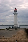 | Hellevoetsluis | South Holland | 18,1 m (17 m above NAP) | Iso WRG 10s (11 nautical miles (20 km)) | 1822 | Valk, J. |
| Westhoofd Lighthouse |  | Ouddorp | South Holland | 52 m (56 m above NAP) | Fl(3) W 15s (30 nautical miles (56 km)) | 1947–1948 | Friedhoff, G. |
| Noordwijk Lighthouse | 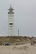 | Noordwijk | South Holland | 25,5 m (33 m above NAP) | Oc(3) W 20s (18 nautical miles (33 km)) | 1921–1922 | Jelsma, C. |
| Hoge vuurtoren Europoort |  | Rotterdam | South Holland | 44 m above NAP | Oc G 6s (16 nautical miles (30 km)) | 1970–1971 | Bouwdienst Rijkswaterstaat |
| Lage vuurtoren Europoort |  | Rotterdam | South Holland | 30 m above NAP | Oc G 6s (16 nautical miles (30 km)) | 1970 | |
| Hoge vuurtoren Maasmond |  | Rotterdam | South Holland | 47 m above NAP | Iso W 4s (21 nautical miles (39 km)) | 1971 | |
| Lage vuurtoren Maasmond |  | Rotterdam | South Holland | 30 m above NAP | Iso W 4s (21 nautical miles (39 km)) | 1971 | |
| Lighthouse at the Maasvlakte |  | Rotterdam | South Holland | 62 m (67 m above NAP) | Fl(5) W 20s (28 nautical miles (52 km)) | 1974 | Colenbrander, W. |
| Hoge vuurtoren Nieuwe Waterweg |  | Rotterdam | South Holland | 44 m above NAP | Iso R 6s (18 nautical miles (33 km)) | 1970 | |
| Lage vuurtoren Nieuwe Waterweg | 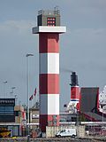 | Rotterdam | South Holland | 30 m above NAP | Iso R 6s (18 nautical miles (33 km)) | 1970 | |
| Scheveningen Lighthouse | 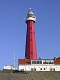 | Scheveningen | South Holland | 30 m (49 m above NAP) | Fl(2) W 10s (29 nautical miles (54 km)) | 1875 | Harder, Quirinus |
| Vuurtoreneiland |  | Durgerdam | North Holland | 19,5 m (18 m above NAP) | Oc WR 5s (14 nautical miles (26 km)) | 1893–2003, 2005- | Loo, A.C. van |