Lemmer

Last updated
Lemmer
Town
Lemmer, zicht op de Kortestreek vanaf de ophaalbrug met de Hervormde kerk RM25749 op de achtergrond IMG 2180 2018-04-17 13.41.jpg
The Kortestreek with the Reformed church
Lemmer wapen.svg
Lemmer-OpenTopo.jpg
Map of Lemmer
Netherlands location map.svg
Red pog.svg
Lemmer
Location in the Netherlands
Coordinates: Coordinates: 52°50′37″N5°42′33″E / 52.8437°N 5.7093°E / 52.8437; 5.7093
Country Flag of the Netherlands.svg Netherlands
Province Frisian flag.svg Friesland
Municipality De Friese Meren vlag.svg De Fryske Marren
Population
 (2017)
  Total10,225
Time zone UTC+1 (CET)
  Summer (DST) UTC+2 (CEST)
Postal code
8530-8532
Telephone area0514

Lemmer (West Frisian : De Lemmer) is a town in the municipality of De Fryske Marren, in the Dutch province of Friesland. Lemmer lies adjacent to the IJsselmeer and the Frisian Lakes and is one of Friesland's best-known surface water sports locations. Lemmer is a bustling lakeside resort in the summer months and attracts not only day-trippers from surrounding communities such as Emmeloord, Urk, and Joure, but also national and international tourists.

Contents

In 2017 the town had 10,225 inhabitants. [1] Residents of Lemmer are called Lemsters. Due to its favorable location in relation to the Randstad, Lemmer attracts many new inhabitants from outside Friesland. As a result, the village has suffered little from the effects of rural flight. The hamlet of Brekkenpolder also belongs to the town, along with most of the hamlet of Tacozijl and a small part of the hamlet of Westend.

History

The original Lemsters settled where the rivers Rien and Zijlroede meet, though it remains unknown when they first did so. Lemmer appears in writing at the beginning of the fourteenth century, though it is mentioned as Lenna in the writings of the bishop of the diocese of Utrecht in 1228. A further link can probably be made with the name Lammerbroeke, which appears in 1165 as an earlier form of Lemsterhoek, a hamlet just west of present-day Lemmer, which was destroyed by the Hollanders around 1400. No rebuilding ensued, but the place and name are still known, especially among sailors and fishermen. Even older names have also survived, such as Lyamer.

Gradually, a settlement grew at the mouth of these inland waterways of the Zuiderzee, a prime place for merchants and artisans.

Lemmer was in a vulnerable position on the Zuiderzee and often fell under the influence of Holland. That happened in 1197, among other times, when Count William I had a castle built in Oosterzee to aid in his subjugation of the lord of Kuinre. In 1422, a castle was built in Lemmer by Duke John III of Bavaria-Straubing, who had been summoned by the Schieringers as patron of Friesland. Known as John "the Pitiless", he certainly would not have been a popular figure in Lemmer.

Duke Charles II of Guelders also interfered with Friesland. He had a blockhouse built in Lemmer in 1521, which housed a garrison. Two years later he handed it over to the Burgundians. What the castles and blockhouse looked like is unknown.

The Spaniards did not leave the village alone either. In 1581, during the Eighty Years' War, they conquered Lemmer, along with the city of Sloten. In the rampjaar of 1672, however, Prince-Bishop von Galen of Münster proved unable to occupy Lemmer as part of the Franco-Dutch War.

In 1799, British troops landed in Lemmer. The War of the Second Coalition had broken out between Great Britain and France, and the Dutch had become involved as "sister republic". British warships sailed the Zuiderzee and the cities of Enkhuizen, Medemblik and Stavoren were occupied. Soon afterwards, the large warships could be seen in Lemmer. The Lemster beurtman , with whom the enterprising Poppe Jans had made many a trip to Amsterdam, was overpowered near Urk and its passengers taken to Stavoren. Two British warships appeared in front of the port of Lemmer on 24 September. Captain James Boorder landed in a sloop - under cover of a white flag - to meet local authorities. A sudden storm forced him to spend the night at De Wildeman Inn. Three days later, he returned and claimed Lemmer for the British, including all ships and cargo. If refused, all of Lemmer would be shot to pieces.

Lemmer rejected their demand fearlessly. It had since been reinforced by 500 armed farmers from Het Bildt, who brought field guns with them. But the town could not withstand the fire of British fourteen, sixteen and eighteen-pound shots. An hour and a half after the attack was started, the flag was raised on the church tower as a sign of surrender. In various places in Friesland, patriots called for civilians and soldiers to liberate Lemmer. On 7 October, there were still 260 soldiers and marines in the town. To prevent an attack by water, they had used chains to block waterways.

Lemmer eventually became one of the most important fishing towns in the Netherlands, thanks in part to its fleet of 146 vessels. With the completion of the Zuiderzee Works between 1924 and 1968, fishery declined incrementally. Lemmer offers a central position in southern Friesland and northern Flevoland. Every year there is the Lemsterweek , a week of cultural events attracting around 85,000 people annually. The Lemsteraak , a traditional sailing ship, originates in Lemmer. De Groene Draeck , the royal yacht of Princess Beatrix, is a notable example of a Lemsteraak.

Notable people

Related Research Articles

<span class="mw-page-title-main">Leeuwarden</span> City and municipality in Friesland, Netherlands

Leeuwarden is a city and municipality in Friesland, Netherlands, with a population of 123,107 (2019). It is the provincial capital and seat of the Provincial Council of Friesland. It is located about 50 km west of Groningen and 110 km north east from the Dutch capital Amsterdam (as the crow flies).

<i>Elfstedentocht</i>

The Elfstedentocht is a long-distance tour skating event on natural ice, almost 200 kilometres (120 mi) long, which is held both as a speed skating competition and a leisure tour. The Elfstedentocht is the biggest ice-skating tour in the world.

<span class="mw-page-title-main">Zuiderzee Works</span> Land reclamation in the Netherlands

The Zuiderzee Works is a man-made system of dams and dikes, land reclamation and water drainage work, in total the largest hydraulic engineering project undertaken by the Netherlands during the twentieth century. The project involved the damming of the Zuiderzee, a large, shallow inlet of the North Sea, and the reclamation of land in the newly enclosed water using polders. Its main purposes are to improve flood protection and create additional land for agriculture.

<span class="mw-page-title-main">Heerenveen</span> Town and municipality in Friesland, Netherlands

Heerenveen is a town and municipality in the province of Friesland (Fryslân), in the Northern Netherlands. In 2021, the town had a population of 29,790 while the municipality had a population 50,859. It is situated 27 km south east of the provincial capital Leeuwarden and is furtherly south west of Groningen, north west of Zwolle and north east of Almere.

<span class="mw-page-title-main">Noordoostpolder</span> Municipality in Flevoland, Netherlands

Noordoostpolder is a polder and municipality in the Flevoland province in the central Netherlands. Formerly, it was also called Urker Land. Emmeloord is the administrative center, located in the heart of the Noordoostpolder.

<span class="mw-page-title-main">Medemblik</span> Municipality in North Holland, Netherlands

Medemblik is a municipality and a town in the Netherlands, in the province of North Holland and the region of West-Frisia. It lies immediately south of the polder and former municipality of Wieringermeer.

<span class="mw-page-title-main">Emmeloord</span> Town in Flevoland, Netherlands

Emmeloord is the administrative centre of the municipality of Noordoostpolder, Flevoland, Netherlands. In 2019, it had a population of 26,055.

<span class="mw-page-title-main">Stavoren</span> City in Friesland, Netherlands

Stavoren is a city in the province of Friesland, Netherlands, on the coast of the IJsselmeer, about 5 km south of Hindeloopen, in the municipality of Súdwest-Fryslân.

<span class="mw-page-title-main">Joure</span> Town in Friesland, Netherlands

Joure is a town in the north of the Netherlands. It is the administrative center of De Fryske Marren, Friesland. With 13,090 inhabitants, it is also the most populous town in the municipality.

<span class="mw-page-title-main">Sloten, Friesland</span> City in Friesland, Netherlands

Sloten is a historical fortified city within the municipality of De Fryske Marren, in the Dutch province of Friesland. Sloten lies adjacent to the Slotermeer and is situated between the towns of Lemmer and Balk.

<span class="mw-page-title-main">St. Lucia's flood</span> Storm tide that affected the Netherlands and Northern Germany in 1287

St. Lucia's flood (Sint-Luciavloed) was a storm tide that affected the Netherlands and Northern Germany on 13/14 December 1287 (OS), St. Lucia Day and the day after, killing approximately 50,000 to 80,000 people in one of the largest floods in recorded history.

<span class="mw-page-title-main">Battle of Warns</span> 1345 battle of the Friso-Hollandic Wars

The Battle of Warns was a battle of the Friso-Hollandic Wars between Count William IV of Holland and the Frisians which took place on 26 September 1345. The annual commemoration of the battle is important for many nationalist Frisians. The Frisians won the battle and repelled the Dutchmen from the eastern coast of the Zuiderzee.

The Friso-Hollandic Wars, also called Frisian-Hollandic Wars, were a series of short medieval wars consisting of the attempts made by the counts of Holland to conquer the free Frisian territories, which lay to the north and east of their domain. These wars were waged off and on from 1256 to 1297, 1324 to 1348, 1396 to 1411, and from 1421 to 1422, although it could be argued that a state of war continued to exist between the County of Holland and the Frisian territories till well after the year 1500.

<span class="mw-page-title-main">Frisian freedom</span> c. 800 – 1523 absence of feudalism and serfdom in Frisia

Frisian freedom was the absence of feudalism and serfdom in Frisia, the area that was originally inhabited by the Frisians. Historical Frisia included the modern provinces of Friesland and Groningen, and the area of West Friesland, in the Netherlands, and East Friesland in Germany. During the period of Frisian freedom the area did not have a sovereign lord who owned and administered the land. The freedom of the Frisians developed in the context of ongoing disputes over the rights of local nobility.

<span class="mw-page-title-main">Makkum, Súdwest-Fryslân</span> Village in Friesland, Netherlands

Makkum is a village of Súdwest-Fryslân municipality, west of Bolsward on the banks of the lake IJsselmeer in the province Friesland of the Netherlands. It had a population of around 3,460 in January 2017, making it the largest village of the former municipally Wûnseradiel. North and south of Makkum are nature reserves Noardwaard and Súdwaard. Belonging to Makkum is the hamlet Ingwier.

<span class="mw-page-title-main">Súdwest-Fryslân</span> Municipality in Friesland, Netherlands

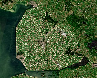
Southwest Friesland is a municipality in the Northern Netherlands, located in the province of Friesland. It had a population of 84,092 in August 2017. Sneek is the municipal seat. With a total area of 841.56 km2, Súdwest-Fryslân is the largest municipality by area in the Netherlands.

<span class="mw-page-title-main">Lordship of Frisia</span> Feudal dominion in the Netherlands

The Lordship of Frisia or Lordship of Friesland was a feudal dominion in the Netherlands. It was formed in 1498 by Maximilian of Habsburg and reformed in 1524 when Emperor Charles V conquered Frisia.

<span class="mw-page-title-main">De Fryske Marren</span> Municipality in Friesland, Netherlands

De Fryske Marren is a municipality of Friesland in the northern Netherlands. It was established 1 January 2014 and consists of the former municipalities of Gaasterlân-Sleat, Lemsterland, Skarsterlân and parts of Boarnsterhim, all four of which were dissolved on the same day. The municipality is located in the province of Friesland, in the north of the Netherlands, and has a population of 51,430 and a combined area of 559.93 km2 (216.19 sq mi).

<span class="mw-page-title-main">Jan Dijkstra</span> Dutch politician

Jan Dijkstra was a Dutch politician.

<span class="mw-page-title-main">Altena, North Brabant</span> Municipality in North Brabant, Netherlands

Altena is a municipality in the Netherlands, on a river island in the very north of the province of North Brabant, bordering the provinces of Gelderland and South Holland. Nearby cities are Dordrecht in the west, Gorinchem in the north, and Waalwijk in the south.

References