Haskerhorne

Last updated
Haskerhorne
Haskerhoarne
Village
Haskerhorne, kerk foto11 2011-04-26 17.51.JPG
Haskerhorne church
Haskerhorne vlag.svg
Haskerhoarne wapen.svg
Map NL Skarsterlan Haskerhoarne.png
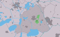
Location in the former Skarsterlân municipality
2010-NL-P02-Fryslan-positiekaart-gemnamen.jpg
Red pog.svg
Haskerhorne
Location in the Netherlands
Netherlands location map.svg
Red pog.svg
Haskerhorne
Haskerhorne (Netherlands)
Coordinates: 52°57′10″N5°49′45″E / 52.95278°N 5.82917°E / 52.95278; 5.82917
Country Flag of the Netherlands.svg Netherlands
Province Frisian flag.svg Friesland
Municipality De Friese Meren vlag.svg De Fryske Marren
Area
[1]
  Total
7.14 km2 (2.76 sq mi)
Elevation
[2]
0.0 m (0.0 ft)
Population
 (2021) [1]
  Total
555
  Density78/km2 (200/sq mi)
Postal code
8506 [1]
Dialing code 0513

Haskerhorne (West Frisian : Haskerhoarne) is a village in De Fryske Marren municipality in the province of Friesland, the Netherlands. It had a population of around 565 in 2017. [3]

Contents

History

The village was first mentioned in 1333 as Hascherahorna, which means the bend/corner near Oudehaske. [4] In 1523, the Protestant Church was destroyed by Burgundian soldiers. In 1691, the church was replaced, and in 1915 replaced again. In 1840, it was home to 139 people. [5]

Before 2014, Haskerhorne was part of the Skarsterlân municipality and before 1984 it was part of Haskerland. [5]

References

  1. 1 2 3 "Kerncijfers wijken en buurten 2021". Central Bureau of Statistics. Retrieved 29 March 2022.
  2. "Postcodetool for 8506AA". Actueel Hoogtebestand Nederland (in Dutch). Het Waterschapshuis. Archived from the original on 21 September 2013. Retrieved 29 March 2022.
  3. Kerncijfers wijken en buurten 2017 - CBS
  4. "Haskerhorne - (geografische naam)". Etymologiebank (in Dutch). Retrieved 29 March 2022.
  5. 1 2 "Haskerhorne". Plaatsengids (in Dutch). Retrieved 29 March 2022.

Commons-logo.svg Media related to Haskerhorne at Wikimedia Commons