Terherne | |
|---|---|
Village | |
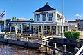
 Terherne church | |
 Flag  Coat of arms | |
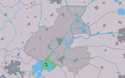 Location in the former Boarnsterhim municipality | |
 Terherne Location in the Netherlands  Terherne Terherne (Netherlands) | |
| Coordinates: 53°2′25″N5°46′51″E / 53.04028°N 5.78083°E | |
| Country | |
| Province | |
| Municipality | |
| Area | |
• Total | 9.15 km2 (3.53 sq mi) |
| Elevation | 0.2 m (0.7 ft) |
| Population (2021) [1] | |
• Total | 760 |
| • Density | 83/km2 (220/sq mi) |
| Postal code | 8493 |
| Dialing code | 0566 |
Terherne (Dutch : Terhorne) is a village in De Fryske Marren in the province of Friesland, the Netherlands. It had a population of around 780 in 2017. [3]