
's-Hertogenbosch, colloquially known as Den Bosch, is a city and municipality in the Netherlands with a population of 160,783. It is the capital of the province of North Brabant and its fourth largest city by population. The city is south of the Maas river and near the Waal.

Delfzijl is a city and former municipality with a population of 25,651 in the province of Groningen in the northeast of the Netherlands. Delfzijl was a sluice between the Delf and the Ems, which became fortified settlement in the 16th century. The fortifications were removed in the late 19th century. Delfzijl is the fifth largest seaport in the Netherlands, and the largest port in the North East of the country.

Napton on the Hill is a village and civil parish in the Stratford-on-Avon District of Warwickshire, England. The population of the civil parish taken at the 2021 census was 1,416.
The North Sea Canal is a Dutch ship canal from Amsterdam to the North Sea at IJmuiden, constructed between 1865 and 1876 to enable seafaring vessels to reach the port of Amsterdam. This man-made channel terminates at Amsterdam in the closed-off IJ Bay, which in turn connects to the Amsterdam-Rhine Canal.
The River Idle is a river in Nottinghamshire, England whose source is the confluence of the River Maun and River Meden near Markham Moor. The Idle flows north from its source through Retford and Bawtry before entering the River Trent at West Stockwith. Its main tributaries are the River Poulter and the River Ryton. The river is navigable to Bawtry, and there is a statutory right of navigation to Retford. Most of the land surrounding the river is a broad flood plain and the river is important for conservation, with Sites of Special Scientific Interest being designated along its course.

The River Ryton is a tributary of the River Idle. It rises close to the Chesterfield Canal near Kiveton Park, and is joined by a series of tributaries near Lindrick Common in the Metropolitan Borough of Rotherham, South Yorkshire, England. Most of its course is in Nottinghamshire, flowing through the town of Worksop. It meanders northwards to join the River Idle near the town of Bawtry on the South Yorkshire-Nottinghamshire border.

The All-American Canal is an 82-mile-long (132 km) aqueduct, located in southeastern California. It conveys water from the Colorado River into the Yuma Project, the Imperial Valley, and to nine cities. It is the Imperial Valley's only water source, and replaced the Alamo Canal, which was located mostly in Mexico. The Imperial Dam, about 30 miles (48 km) northeast of Yuma, Arizona on the Colorado River, diverts water into the All-American Canal, which runs to just west of Calexico, California before its last branch heads mostly north into the Imperial Valley. Smaller canals branching off the All-American Canal move water into the Yuma Valley and the Imperial Valley. These canal systems irrigate up to 630,000 acres (250,000 ha) of crop land and have made possible a greatly increased crop yield in this area, originally one of the driest on earth. It is the largest irrigation canal in the world, carrying a maximum of 26,155 cubic feet per second (740.6 m3/s). Agricultural runoff from the All-American Canal drains into the Salton Sea.

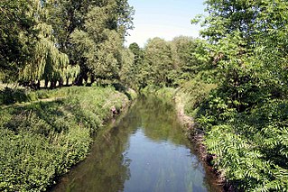
The Oude Rijn is a branch of the Rhine delta in the Dutch provinces of Utrecht and South Holland, starting west of Utrecht, at Harmelen, and running by a mechanical pumping station into the North Sea at Katwijk. Its present-day length is 52 kilometres.

The Dommel is a small river in Belgium and the Netherlands, left tributary of the Dieze. It is 120 km long, of which 85 km are in the Netherlands. The Dommel takes in water from the Keersop, Tongelreep, Run, Gender and Kleine Dommel streams and merges at 's-Hertogenbosch with the Aa stream to form the river Dieze, which subsequently flows towards the Meuse. The main cities and towns along the Dommel's course are Peer, Neerpelt, Valkenswaard, Dommelen, Eindhoven, Son en Breugel, Sint-Oedenrode, Boxtel, Sint-Michielsgestel and 's-Hertogenbosch.

Castaic Dam is an embankment dam in northwestern Los Angeles County, California, in the unincorporated area of Castaic. Although located on Castaic Creek, a major tributary of the Santa Clara River, Castaic Creek provides little of its water. The lake is the terminus of the West Branch of the California Aqueduct, part of the State Water Project. The dam was built by the California Department of Water Resources and construction was completed in 1973. The lake has a capacity of 325,000 acre-feet (401,000,000 m3) and stores drinking water for the western portion of the Greater Los Angeles Area.

Artemare is a commune in the Ain department in the Auvergne-Rhône-Alpes region of eastern France.

Grosvenor Canal was a canal in the Pimlico area of London, opened in 1824. It was progressively shortened, as first the railways to Victoria Station and then the Ebury Bridge housing estate were built over it. It remained in use until 1995, enabling barges to be loaded with refuse for removal from the city, making it the last canal in London to operate commercially. A small part of it remains within the Grosvenor Waterside development.

Langweer is a village in Friesland in the municipality De Fryske Marren. The town was established in 1256, and has a population of 1,105 . Langweer has a rich trading history, and it is located at a small lake (Langweerderwielen).
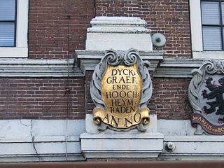
In the Netherlands, a water board, water council or water authority is a regional governing body solely charged with the management of surface water in the environment. Water boards are independent of administrative governing bodies like provinces and municipalities. In general, they are responsible for managing rivers and canals, issues with the flow of watercourses and drainage issues, water collection, flood and erosion prevention and provision of potable water. They manage polder systems, water levels, water barriers and locks, enforcements, water quality and sewage treatment in their respective regions. The concept of a coordinating "High Water Authority" (Hoogheemraadschap) originated in what now is the province of South Holland in the 12th century.
Communipaw is a neighborhood in Jersey City in Hudson County, in the U.S. state of New Jersey. It is located west of Liberty State Park and east of Bergen Hill, and the site of one of the earliest European settlements in North America. It gives its name to the historic avenue which runs from its eastern end near Liberty State Park Station through the neighborhoods of Bergen-Lafayette and the West Side that then becomes the Lincoln Highway. Communipaw Junction, or simply The Junction, is an intersection where Communipaw, Summit Avenue, Garfield Avenue, and Grand Street meet, and where the toll house for the Bergen Point Plank Road was situated. Communipaw Cove at Upper New York Bay, is part of the 36-acre (150,000 m2) state nature preserve in the park and one of the few remaining tidal salt marshes in the Hudson River estuary.

De Sweachmermolen is a smock mill between Langweer and Boornzwaag, Friesland, Netherlands which was built in 1782. The mill has two functions: it is a drainage mill and a corn mill. It has been restored to working order as a drainage mill and is listed as a Rijksmonument, number 13241.
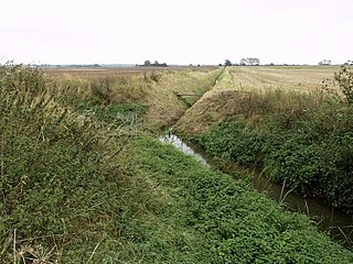
The River Foulness is a river in the East Riding of Yorkshire, England. Its name is derived from Old English fūle[n] ēa, meaning “dirty water”. Maintenance responsibilities for the river transferred from the Environment Agency to the Market Weighton Drainage Board on 1 October 2011. Market Weighton Drainage Board subsequently amalgamated with the Lower Ouse Internal Drainage Board on 1 April 2012 to create the Ouse and Humber Drainage Board. The river discharges into the Humber Estuary via Market Weighton Canal. Water levels within the river, its tributaries and the canal are managed and controlled by the Environment Agency. The river lies in an area known as the Humberhead Levels.

The Grimburgwal is a small canal and street in the center of Amsterdam.

The Nymphenburg Palace Park ranks among the finest and most important examples of garden design in Germany. In combination with the palace buildings, the Grand circle entrance structures and the expansive park landscape form the ensemble of the Nymphenburg Summer Residence of Bavarian dukes and kings, located in the modern Munich Neuhausen-Nymphenburg borough. The site is a Listed Monument, a Protected Landscape and to a great extent a Natura2000 area.

The Hoendiep is a canal in the Dutch province of Groningen, located between the city of Groningen and Zuidhorn. Before 1938, the current section of the Van Starkenborgh Canal from Zuidhorn to the Frisian border was also called Hoendiep. The road on the south side of the Van Starkenborgh Canal is still called Hoendiep.


