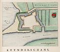
Kuinre

Last updated
Kuinre
De Kuunder
Village
Kuinre Panorama 10.JPG
Skyline of Kuinre
Flag of Kuinre former municipality.gif
Kuinre wapen.svg
2010-NL-P04-Overijssel-positiekaart-gemnamen.jpg
Red pog.svg
Kuinre
Location in the Netherlands
Netherlands location map.svg
Red pog.svg
Kuinre
Kuinre (Netherlands)
Coordinates: 52°47′11″N5°50′36″E / 52.78639°N 5.84333°E / 52.78639; 5.84333
Country Netherlands
Province Overijssel
Municipality Steenwijkerland
Area
[1]
  Total13.10 km2 (5.06 sq mi)
Elevation
[2]
0 m (0 ft)
Population
 (2021) [1]
  Total930
  Density71/km2 (180/sq mi)
Time zone UTC+1 (CET)
  Summer (DST) UTC+2 (CEST)
Postal code
8374 [1]
Dialing code 0527

Kuinre (Low Saxon: De Kuunder) is a village in the Dutch province of Overijssel. It was a separate municipality until 1973, when it became a part of IJsselham, which in turn merged into the municipality of Steenwijkerland in 2001. [3]

Contents

Kuinre is a former harbour town with a rich history. Back in the days of the Zuiderzee, Kuinre's harbour was an important port of the Zuiderzee. After completion of the Noordoostpolder Kuinre became landlocked; companies, shops, and fishermen went out of business.

History

Kuinre is a village which developed at the mouth of the Tjonger  [ nl ] and the Linde. Around 1165, a castle was built about one kilometre south of the settlement by the Prince-bishop of Utrecht. In 1196, the castle was destroyed by the Count of Holland. In 1376, Kuinre provided shelter for pirates. [4] In 1385, it was given buurrecht, significant privileges. [5] In 1672, Kuinre was destroyed by the Prince-Bishop of Münster. Later, it became a quiet fishing harbour. [4] The excavation of peat resulted in a revival as an export harbour. In 1840, it was home to 870 people. [6]

The Afsluitdijk, closure dike which turned the Zuiderzee into a lake, resulted in an economic decline. In 1939, a petition was signed by 348 of the 372 voters to transfer Kuinre from Overijssel to Friesland, because Kuinre felt neglected by the province, and thought that its independence as a municipality was threatened. The petition was ignored. In 1973, it ceased to be an independent municipality. [6]

Notable people

Related Research Articles

<span class="mw-page-title-main">Flevoland</span> Province of the Netherlands

Flevoland is the twelfth and youngest province of the Netherlands, established in 1986, when the southern and eastern Flevopolders, together with the Noordoostpolder, were merged into one provincial entity. It is in the centre of the country in the former Zuiderzee, which was turned into the freshwater IJsselmeer by the closure of the Afsluitdijk in 1932. Almost all of the land belonging to Flevoland was reclaimed in the 1950s and 1960s while splitting the Markermeer and Bordering lakes from the IJsselmeer. As to dry land, it is the smallest province of the Netherlands at 1,412 km2 (545 sq mi), but not gross land as that includes much of the waters of the fresh water lakes (meres) mentioned.

<span class="mw-page-title-main">Zuiderzee Works</span> Land reclamation in the Netherlands

The Zuiderzee Works is a man-made system of dams and dikes, land reclamation and water drainage work, in total the largest hydraulic engineering project undertaken by the Netherlands during the twentieth century. The project involved the damming of the Zuiderzee, a large, shallow inlet of the North Sea, and the reclamation of land in the newly enclosed water using polders. Its main purposes are to improve flood protection and create additional land for agriculture.

<span class="mw-page-title-main">Hof van Twente</span> Municipality in Overijssel, Netherlands

Hof van Twente is a municipality in the eastern Netherlands, province Overijssel. The municipality was established 1 January 2001 as the result of the merger of the municipalities of Diepenheim, Goor, Markelo, Ambt Delden, and Stad Delden.

<span class="mw-page-title-main">Ommen</span> Municipality in Overijssel, Netherlands

Ommen is a municipality and a Hanseatic city in the eastern Netherlands. It is located in the Vecht valley of the Salland region in Overijssel. Historical records first name Ommen in the early 12th century and it was officially founded as a city in 1248. The municipality had a population of 18,295 in 2021 and covers an area of 182.01 km2 (70.27 sq mi).

<span class="mw-page-title-main">Steenwijkerland</span> Municipality in Overijssel, Netherlands

Steenwijkerland is a municipality in the province of Overijssel, in the eastern Netherlands. Prior to a name change in 2003, it was known as Steenwijk.

<span class="mw-page-title-main">Lemmer</span> Town in Friesland, Netherlands

Lemmer is a town in the municipality of De Fryske Marren, in the Dutch province of Friesland. Lemmer lies adjacent to the IJsselmeer and the Frisian Lakes and is one of Friesland's best-known surface water sports locations. Lemmer is a bustling lakeside resort in the summer months and attracts not only day-trippers from surrounding communities such as Emmeloord, Urk, and Joure, but also national and international tourists.

<span class="mw-page-title-main">Gramsbergen</span> Small city in Overijssel, Netherlands

Gramsbergen is a small Dutch city on the Vechte, located in the municipality of Hardenberg and the province of Overijssel. The town is located on corridors of different transportation modes: The N34, the Zwolle - Emmen railway and the Almelo - de Haandrik canal.

<span class="mw-page-title-main">Zoutkamp</span> Village in Groningen, Netherlands

Zoutkamp is a village in the municipality Het Hogeland which is part of the province Groningen in the Netherlands. The village started as a sconce. During the Dutch Revolt, it was the site of the Battle of Zoutkamp. Later it became a fishing village. The harbour was moved to Lauwersoog in 1969 as a result of the closure of the Lauwersmeer, and is nowadays used for recreational purposes. The economy of the village mainly depends on fishing.

<span class="mw-page-title-main">Genemuiden</span> City in Overijssel, Netherlands

Genemuiden is a city located in the north western part of the Province of Overijssel. It received city rights in 1275, which is also the first time Genemuiden gets mentioned in history.

<span class="mw-page-title-main">Vollenhove</span> City in Overijssel, Netherlands

Vollenhove is a city in the Dutch province of Overijssel. It is located in the municipality of Steenwijkerland, southwest of Steenwijk. Until the Noordoostpolder was drained, it was located on the coast of the Zuiderzee.

<span class="mw-page-title-main">Hagestein</span> Village in Utrecht, Netherlands

Hagestein is a village and former city in the municipality of Vijfheerenlanden, Utrecht, Netherlands, on the Lek River, about 2 km east of Vianen. It received city rights in 1382. Hagestein was destroyed in 1405 by the Count of Holland and the Prince-Bishop of Utrecht.

<span class="mw-page-title-main">Blokzijl</span> City in Overijssel, Netherlands

Blokzijl is a small city located southwest of Steenwijk in the province of Overijssel, the Netherlands. The city is a major tourist destination near the De Weerribben-Wieden National Park and attracts many water sports enthusiasts.

<span class="mw-page-title-main">Dedemsvaart</span> Town in Overijssel, Netherlands

Dedemsvaart is a town in Overijssel, the Netherlands.

<span class="mw-page-title-main">Diepenheim</span> Small city in Overijssel, Netherlands

Diepenheim is a small city in the Dutch province of Overijssel. It is located in the municipality of Hof van Twente, about 5 km southwest of Goor. Diepenheim was a separate municipality until 2001, when it became a part of Hof van Twente.

<span class="mw-page-title-main">Luttelgeest</span> Village in Flevoland, Netherlands

Luttelgeest is a village in the Dutch province of Flevoland. It is a part of the municipality of Noordoostpolder, and was created in 1950 as one of ten planned villages around the new city of Emmeloord.

<span class="mw-page-title-main">Salland</span> Area of the Netherlands

Salland is a historical dominion in the west and north of the present Dutch province of Overijssel. Nowadays Salland is usually used to indicate a region corresponding to the part of the former dominion more or less to the west of Twente.

<span class="mw-page-title-main">Blankenham</span> Village in Overijssel, Netherlands

Blankenham is a village in the Netherlands, in the municipality of Steenwijkerland. Until 1973, it was a separate municipality.

<span class="mw-page-title-main">IJsselham</span> Hamlet in Overijssel, Netherlands

IJsselham is a hamlet in the Dutch province of Overijssel. It is located in the municipality of Steenwijkerland, about 12 km west of Steenwijk, and 2 km southwest of Oldemarkt.

<span class="mw-page-title-main">Oldemarkt</span> Village in Overijssel, Netherlands

Oldemarkt is a village in the Dutch province of Overijssel. It is located in the municipality of Steenwijkerland, about 12 km west of Steenwijk. Oldemarkt was a separate municipality until 1973, when it became a part of IJsselham.

<span class="mw-page-title-main">Hoonhorst</span> Village in Overijssel, Netherlands

Hoonhorst is a village in the municipality of Dalfsen in the province of Overijssel, Netherlands. It is a Catholic enclave in a Protestant area. It located about 9 kilometres (5.6 mi) east of Zwolle.

References

  1. 1 2 3 "Kerncijfers wijken en buurten 2021". Central Bureau of Statistics. Retrieved 17 March 2022.
  2. "Postcodetool for 8374EA". Actueel Hoogtebestand Nederland (in Dutch). Het Waterschapshuis. Retrieved 16 March 2022.
  3. Ad van der Meer and Onno Boonstra, Repertorium van Nederlandse gemeenten , KNAW, 2011.
  4. 1 2 Ronald Stenvert & Jan ten Hove (1998). "Kuinre" (in Dutch). Zwolle: Waanders. p. 209. ISBN   90 400 9200 1 . Retrieved 17 March 2022.
  5. "Buurrecht van Kuinre" (PDF). Historische vereniging IJsselham (in Dutch). 22 March 1385. Retrieved 17 March 2022.
  6. 1 2 "Kuinre". Plaatsengids (in Dutch). Retrieved 17 March 2022.
  7. "Klaas Johan "Klaas Jan" Pen". Olympedia. Retrieved 17 March 2022.