Vollenhove

Last updated

Vollenhove
City
Vollenhove pano 2.JPG
Skyline of Vollenhove
Vollenhove vlag.svg
Vollenhove wapen.svg
2010-NL-P04-Overijssel-positiekaart-gemnamen.jpg
Red pog.svg
Vollenhove
Location in the Netherlands
Netherlands location map.svg
Red pog.svg
Vollenhove
Vollenhove (Netherlands)
Coordinates: 52°41′N5°57′E / 52.683°N 5.950°E / 52.683; 5.950 Coordinates: 52°41′N5°57′E / 52.683°N 5.950°E / 52.683; 5.950
Country Netherlands
Province Overijssel
Municipality Steenwijkerland
Area
[1]
  Total9.32 km2 (3.60 sq mi)
Elevation
[2]
4 m (13 ft)
Population
 (2021) [1]
  Total4,295
  Density460/km2 (1,200/sq mi)
Time zone UTC+1 (CET)
  Summer (DST) UTC+2 (CEST)
Postal code
8325 [1]
Dialing code 0527
Major roads N331

Vollenhove is a city in the Dutch province of Overijssel. It is located in the municipality of Steenwijkerland, southwest of Steenwijk. Until the Noordoostpolder was drained, it was located on the coast of the Zuiderzee.

Contents

Vollenhove received city rights in 1354. Later it was the main city in this region, that was formerly called Land van Vollenhove. Vollenhove was the summer residence of the bishop of Utrecht, the ruler of these parts. He lived in the castle Toutenburg, of which only some small ruins are left now. To be near their lord, quite some nobility moved to Vollenhove. They built their estates (Dutch: havezates) in the town, which was unique. Therefore, Vollenhove was called the city of palaces. Like Blokzijl, peat transport to Holland by ship caused the small city to flourish during the 17th century.

Vollenhove was a separate municipality until 1973, when it became a part of Brederwiede. Between 1818 and 1942, the municipality was divided into two parts, Stad Vollenhove (the city) and Ambt Vollenhove (the countryside). [3]

History

Vollenhove is already listed (as Fulnaho) in 944. The area was once a forest owned by Otto the Great. He gave Bishop of Utrecht Balderik permission to hunt there. In 1010 Emperor Henry II gave the area Sillva Fulnaho (Forest Vollenhove) to the bishop of Utrecht.[ citation needed ] In the 12th century, Bishop Godfried van Rhenen built a castle in the Almere, the Olde Huys, with a keep and a chapel. In the 14th century, the castle was repeatedly attacked by the Frisians from Stellingwerven. The village Op ten Camph was built around the castle. On 12 July 1354 it was given a city charter. After 1380 the city was designated as Vollenho.

The heyday of the city Vollenhove was in the first half of the 15th century. Vollenhove was important because of the sturgeon fishing and was a bijstad of the League. Earthen walls and gates were also constructed to defend the city. In the first half of the 16th century the city flourished. Joris Schenck van Toutenburg became sheriff and later became governor of Overijssel for Karel the Fifth. Just outside the city Schenck built a castle called Toutenburg. This residence was the administrative center for the three northern provinces of Groningen, Friesland and Overijssel. Drenthe did not count because it was considered to poor. At the outbreak of the Eighty Years' War Vollenhove lost the role of administrative center, and in the following centuries, the town withered away.

In 1818 was divided into Vollenhove City and Vollenhove office, the country that Vollenhove heard. In the second half of the 19th century Vollenhove flourished again briefly. The moat of the Olde Huys was fishing port and the castle was demolished. When in 1859 the island was evacuated Schokland, drew the most Schokkers in the midst of the remains of the castle. At the end of the 19th century, a new port was built and a specific fishing boat, the Vollenhovense sphere. The construction of the Dam (1932) came to an end the Zuiderzee fishing. Vollenhove was the beginning of World War II as a major port for the reclamation work of the northeast.

Pictures

Events

The most well-known event of the city is the annual flower parade. Corso Vollenhove takes place on the last Saturday of August. The parade has always thousands of visitors.

There are about 12 floats with different subjects and roughly 100,000–200,000 flowers per float. Several quality marching bands from in and outside the Netherlands are contracted to play in the parade.

Trivia

The celebration of the 650-year anniversary as a city on 12 July 2004 was attended by Mr. Pieter van Vollenhoven, he is the husband of Her Royal Highness Princess Margriet of the Netherlands. He was named an honorary citizen of the town. Incidentally, his surname has nothing to do with the town Vollenhove.

Related Research Articles

Zuiderzee Former inland sea in the Netherlands, now the IJsselmeer

The Zuiderzee or Zuider Zee was a shallow bay of the North Sea in the northwest of the Netherlands, extending about 100 km inland and at most 50 km wide, with an overall depth of about 4 to 5 metres (13–16 feet) and a coastline of about 300 km. It covered 5,000 km2 (1,900 sq mi). Its name is Dutch for "southern sea", indicating that the name originates in Friesland, to the north of the Zuiderzee. In the 20th century the majority of the Zuiderzee was closed off from the North Sea by the construction of the Afsluitdijk, leaving the mouth of the inlet to become part of the Wadden Sea. The salt water inlet changed into a fresh water lake now called the IJsselmeer after the river that drains into it, and by means of drainage and polders, an area of some 1,500 km2 (580 sq mi) was reclaimed as land. This land eventually became the province of Flevoland, with a population of nearly 400,000 (2011).

Kampen, Overijssel City and municipality in Overijssel, Netherlands

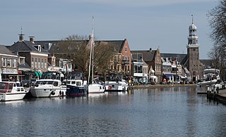
Kampen is a city and municipality in the province of Overijssel, Netherlands. A member of the former Hanseatic League, it is located at the lower reaches of the river IJssel.

Ommen Municipality in Overijssel, Netherlands

Ommen is a municipality and a Hanseatic city in the eastern Netherlands. It is located in the Vecht valley of the Salland region in Overijssel. Historical records first name Ommen in the early 12th century and it was officially founded as a city in 1248. The municipality had a population of 17,813 in 2019 and covers an area of 182.01 km2 (70.27 sq mi).

Steenwijkerland Municipality in Overijssel, Netherlands

Steenwijkerland is a municipality in the province of Overijssel, in the eastern Netherlands. It was called Steenwijk before 2003.

Lemmer Town in Friesland, Netherlands

Lemmer is a town in the municipality of De Fryske Marren, in the Dutch province of Friesland. Lemmer lies adjacent to the IJsselmeer and the Frisian Lakes and is one of Friesland's best-known surface water sports locations. Lemmer is a bustling lakeside resort in the summer months and attracts not only day-trippers from surrounding communities such as Emmeloord, Urk, and Joure, but also national and international tourists.

Wijhe Town in Overijssel, Netherlands

Wijhe is a village in the Dutch province of Overijssel. It is located in the municipality of Olst-Wijhe and is situated about 12 km south of Zwolle on the banks of the river IJssel.

Grafhorst Small city in Overijssel, Netherlands

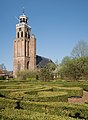
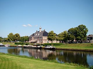
Grafhorst is a small city about 3 km north of Kampen, in the Dutch province of Overijssel. It received city rights in 1333 from Jan van Diest, the Prince-Bishop of Utrecht.

Hagestein Village in Utrecht, Netherlands

Hagestein is a village and former city in the municipality of Vijfheerenlanden, Utrecht, Netherlands, on the Lek River, about 2 km east of Vianen. It received city rights in 1382. Hagestein was destroyed in 1405 by the Count of Holland and the Prince-Bishop of Utrecht.

Diepenheim Small city in Overijssel, Netherlands

Diepenheim is a small city in the Dutch province of Overijssel. It is located in the municipality of Hof van Twente, about 5 km southwest of Goor. Diepenheim was a separate municipality until 2001, when it became a part of Hof van Twente.

Delden City in Overijssel, Netherlands

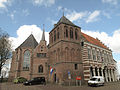
Delden is a city in the Dutch province of Overijssel and, since 2001, in the municipality of Hof van Twente. It received city rights in 1333. Twickel Castle is a famous landmark near Delden.

Salland Area of the Netherlands

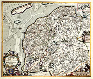
Salland is a historical dominion in the west and north of the present Dutch province of Overijssel. Nowadays Salland is usually used to indicate a region corresponding to the part of the former dominion more or less to the west of Twente.

Ootmarsum City in Overijssel, Netherlands

Ootmarsum is a city in the Dutch province of Overijssel. It is a part of the municipality of Dinkelland, and lies about 10 km north of Oldenzaal.

Guelders Wars Series of conflicts in the Low Countries

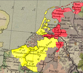
The Guelders Wars were a series of conflicts in the Low Countries between the Duke of Burgundy, who controlled Holland, Flanders, Brabant, and Hainaut on the one side, and Charles, Duke of Guelders, who controlled Guelders, Groningen, and Frisia on the other side.

Schellingwoude Neighbourhood of Amsterdam in North Holland, Netherlands

Schellingwoude is a neighbourhood of Amsterdam, Netherlands. A former village located on the northern shore of the IJ, in the province of North Holland, it was a separate municipality between 1817 and 1857, when it was merged with Ransdorp; the latter merged with Amsterdam in 1921. Nowadays it is part of the Amsterdam-Noord borough and the Landelijk Noord district.

Kuinre Village in Overijssel, Netherlands

Kuinre is a village in the Dutch province of Overijssel. It was a separate municipality until 1973, when it became a part of IJsselham, which in turn merged into the municipality of Steenwijkerland in 2001.

Frederik V Schenck van Toutenburg

Frederik Schenck van Toutenburg was the first Archbishop of Utrecht (1559–1580). Prior to Schenck's ministry as archbishop, Utrecht was a bishopric with a succession of sixty bishops. The last bishop of Utrecht, prior to Schenck was George van Egmond. After Schenck's death in 1580, the see would remain vacant until Sasbold Vosmeer assumed the archbishopric in 1602.

Georg Schenck van Toutenburg Dutch stadtholder (1480–1540)

Georg Schenck van Toutenburg was Stadhouder of Friesland (1521-1540). Later he was also Stadholder of Overijssel, Drenthe and Groningen. His son Frederick was the first archbishop of Utrecht.

Lordship of Frisia Feudal dominion in the Netherlands

The Lordship of Frisia or Lordship of Friesland was a feudal dominion in the Netherlands. It was formed in 1524 when Emperor Charles V conquered Frisia.

Lordship of Utrecht

The Lordship of Utrecht was formed in 1528 when Charles V of Habsburg conquered the Bishopric of Utrecht, during the Guelders Wars.

The historic diocese of Utrecht (695–1580) was a Roman Catholic diocese and archdiocese in the Low Countries before and during the Protestant Reformation.

References

  1. 1 2 3 "Kerncijfers wijken en buurten 2021". Central Bureau of Statistics. Retrieved 17 March 2022.
  2. "Postcodetool for 8325AA". Actueel Hoogtebestand Nederland (in Dutch). Het Waterschapshuis. Retrieved 17 March 2022.
  3. Ad van der Meer and Onno Boonstra, "Repertorium van Nederlandse gemeenten", KNAW, 2006. "KNAW > Publicaties > Detailpagina". Archived from the original on 20 February 2007. Retrieved 3 December 2009.