Flevoland is the twelfth and newest province of the Netherlands, established in 1986, when the southern and eastern Flevopolders, together with the Noordoostpolder, were merged into one provincial entity. It is in the centre of the country in the former Zuiderzee, which was turned into the freshwater IJsselmeer by the closure of the Afsluitdijk in 1932. Almost all of the land belonging to Flevoland was reclaimed in the 1950s and 1960s while splitting the Markermeer and Bordering lakes from the IJsselmeer. As to dry land, it is the smallest province of the Netherlands at 1,410 km2 (540 sq mi), but not gross land as that includes much of the waters of the fresh water lakes (meres) mentioned.
Zeeland is the westernmost and least populous province of the Netherlands. The province, located in the southwest of the country, borders North Brabant to the east, South Holland to the north, as well as the country of Belgium to the south and west. It consists of a number of islands and peninsulas and a strip bordering the Flemish provinces of East and West Flanders. Its capital is Middelburg with a population of 48,544 as of November 2019, although the largest municipality in Zeeland is Terneuzen. Zeeland has two seaports: Vlissingen and Terneuzen. Its area is 2,933 square kilometres (1,132 sq mi), of which 1,154 square kilometres (446 sq mi) is water; it had a population of about 391,000 as of January 2023.

The Zuiderzee or Zuider Zee, historically called Lake Almere and Lake Flevo, was a shallow bay of the North Sea in the northwest of the Netherlands. It extended about 100 km inland and at most 50 km wide, with an overall depth of about 4 to 5 metres (13–16 feet) and a coastline of about 300 km. It covered 5,000 km2 (1,900 sq mi). Its name is Dutch for "southern sea", indicating that the name originates in Friesland, to the north of the Zuiderzee.

The geography of the European Netherlands is unusual in that much of its land has been reclaimed from the sea and is below sea level, protected by dikes. It is a small country with a total area of 41,545 km2 (16,041 sq mi) and ranked 131st. With a population of 17.4 million and density of 521/km2 (1,350/sq mi) makes it the second most densely populated member of the European Union after Malta, and the 12th most densely populated country in the world, behind only three countries with a population over 16 million. Consequently, the Netherlands is highly urbanized.

Overijssel is a province of the Netherlands located in the eastern part of the country. The province's name comes from the perspective of the Episcopal principality of Utrecht, which held the territory until 1528. The capital city of Overijssel is Zwolle and the largest city is Enschede. The province had a population of about 1,184,000 as of January 2023. The land mostly consists of grasslands and some forests ; it also borders a small part of the IJsselmeer to the west.
North Holland is a province of the Netherlands in the northwestern part of the country. It is located on the North Sea, north of South Holland and Utrecht, and west of Friesland and Flevoland. As of January 2023, it had a population of about 2,952,000 and a total area of 4,092 km2 (1,580 sq mi), of which 1,429 km2 (552 sq mi) is water.

There are twelve provinces of the Netherlands representing the administrative layer between the national government and the local governments, with responsibility for matters of subnational or regional importance.

The Zuiderzee Works is a system of dams and dikes, land reclamation and water drainage work, which was the largest hydraulic engineering project undertaken by the Netherlands during the twentieth century. The project involved the damming of the Zuiderzee, a large, shallow inlet of the North Sea, and the reclamation of land in the newly enclosed water using polders. Its main purposes are to improve flood protection and create additional land for agriculture.
Steenwijkerland is a municipality in the province of Overijssel, in the eastern Netherlands. Prior to a name change in 2003, it was known as Steenwijk.

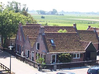
Blokzijl is a small city located southwest of Steenwijk in the province of Overijssel, the Netherlands. The city is a major tourist destination near the De Weerribben-Wieden National Park and attracts many water sports enthusiasts.
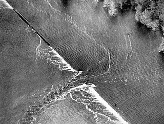
A levee breach or levee failure is a situation where a levee fails or is intentionally breached, causing the previously contained water to flood the land behind the levee.
Wieden is the fourth district of Vienna, Austria.
Moddergat is a fishing village in Noardeast-Fryslân in the province of Friesland, the Netherlands. It had a population of around 221 in January 2017. Before 2019, the village was part of the Dongeradeel municipality.
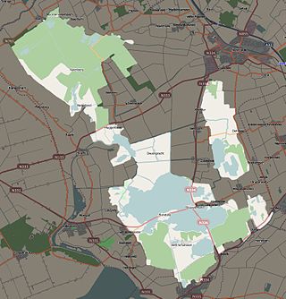
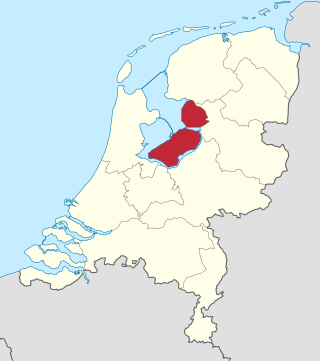
Weerribben-Wieden National Park is a Dutch national park in the Steenwijkerland and Zwartewaterland municipalities in the Overijssel province. Comprising the largest bog of Northwestern Europe, the park consists of two areas, De Weerribben and De Wieden; it has an area of roughly 100 square kilometres (39 sq mi). The park was founded in 1992, although De Wieden was added later, in 2009.

Kalenberg is a tourist hamlet within the De Weerribben-Wieden National Park in the Dutch province of Overijssel. The hamlet belongs to the municipality of Steenwijkerland.
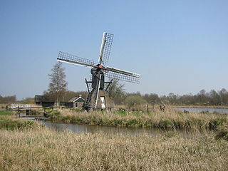
De Wicher is a drainage mill near the village of Kalenberg, Overijssel, Netherlands. It is a hollow post windmill of the type called spinnenkop by the Dutch. The mill is in working order and used to drain the reed beds during winter to improve accessibility for reed cutters.
A Tjasker is a type of small drainage windmill used in the Netherlands and north Germany. There are seven tjaskers remaining in Overijssel, all located in the marshy region in the northwest corner of the province.
Ossenzijl is a village in the municipality Steenwijkerland of the Dutch province of Overijssel. It started as a sluice owned by the Osse family. It is an entry point to the Weerribben-Wieden National Park.

Mark Frans Strolenberg is a Dutch politician of the conservative liberal People's Party for Freedom and Democracy (VVD). He founded an Internet company at the age of eighteen and later worked as an IT professional for different companies. Strolenberg, born and raised in Hoogeveen, served on the town's municipal council next to his job between 2009 and 2021, and he has been a member of his local water authority in the years 2004–23 with a short hiatus. He unsuccessfully ran for member of the House of Representatives in the March 2021 general election, but he was appointed to that body in September after the resignation of Tamara van Ark.

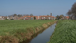
Sint Jansklooster is a village in the municipality Steenwijkerland of the Dutch province of Overijssel. It started as a monastery. The village is located near the Weerribben-Wieden National Park, and organises an annual bloemencorso.


