
The J.C.J. van Speijk Lighthouse is a lighthouse on the North Sea coast near Egmond aan Zee, in the municipality of Bergen, North Holland, in the Netherlands. The foundation of the lighthouse, shaped like a tomb, is the official Dutch memorial to Jan van Speyk, a hero to the Dutch people.
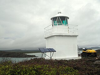
Eborac Island Light is an active lighthouse on Eborac Island, a small rocky island in the Adolphus Channel just off Cape York, the northern tip of Cape York Peninsula, Far North Queensland, Australia. It guides ships into the coastal channel inside the Great Barrier Reef. A concrete structure was built in 1921 and converted to solar power in 1990. It was replaced with a fiberglass structure in 2012.

Wyborn Reef Light is an active lighthouse located at Wyborn Reef, formerly known as Y Reef, about 16 kilometres (9.9 mi) southeast of Albany Island, east of the tip of Cape York Peninsula, Queensland, Australia. It marks the entrance to the Albany Passage. The lighthouse was constructed in 1938 and upgraded in 1991 and 1995. The structure is a stainless steel tower with a fiberglass hut within the framework, carrying a lantern.
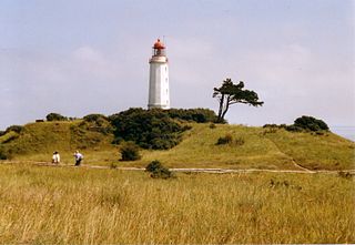
Dornbusch Lighthouse refers to the lighthouse officially designated as Leuchtfeuer Dornbusch/Hiddensee in the north of the German island of Hiddensee in Mecklenburg-Vorpommern on the Baltic Sea coast. Its international serial number is C 2588.

The North Bull Lighthouse, is an active aid to navigation located at the mouth of the River Liffey, near Dublin, Ireland. It is one of four lighthouses that help guide shipping into the Liffey, and the Port of Dublin, all of which are operated and maintained by the Dublin Port Company.

Barrettinelli di Fuori Lighthouse is a light situated on the granitic Barrettinelli rocks, 103 metres (338 ft) long and 62 metres (203 ft) wide, in the Maddalena archipelago at 1.35 kilometres (0.84 mi) east of Isola Santa Maria and 300 metres (980 ft) north of Isola Corcelli.

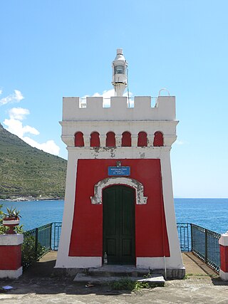
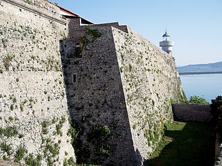
Portoferraio lighthouse, called Faro del Forte Stella Lighthouse since is placed on the northern rampart of Forte Stella built in 1548 by Cosimo I de' Medici in Portoferraio, Elba.

Büsum Lighthouse is an active 20th century lighthouse located in Büsum a fishing and tourist town, which lies on North Sea coast of Schleswig-Holstein, in Germany. The current lighthouse is the second to be built in the town, two other separate breakwater lights mark the entrance of the small harbour from the North Sea.

Santa Maria di Leuca lighthouse is an active light located at the extremity of Santa Maria di Leuca nearby the same name Sanctuary.

Capo Peloro Lighthouse is an active lighthouse located in Punta del Faro on the Strait of Messina, the most north-eastern promontory of Sicily, settled in the Province of Messina, the place closest to Calabria.
Punta del Fortino Lighthouse is an active lighthouse located at the end of the south western point of the Bay of Sapri, Campania on the Tyrrhenian Sea.
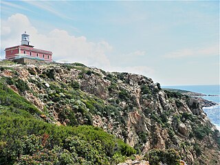
Capo Spartivento Lighthouse is an active lighthouse located on Cape Spartivento promontory which is the southernmost point of Sardinia and represents the eastern boundary of the Gulf of Teulada and the western limit of the Gulf of Cagliari on the Tyrrhenian Sea. The structure is situated in the municipality of Domus de Maria.

Isola dei Cavoli Lighthouse is an active lighthouse located on a small islet, 690 metres (2,260 ft) from Cape Carbonara, the southernmost tip of western Sardinia in the municipality of Villasimius on the Tyrrhenian Sea.

Isola Razzoli Lighthouse is an active lighthouse located on an islet, 2.45 kilometres (1.52 mi) long, in the Maddalena archipelago. The lighthouse is the northernmost in Sardinia, on the eastern approach to the Strait of Bonifacio, and is at 7.42 kilometres (4.61 mi) from the French Lavezzi archipelago. The island is in the municipality of La Maddalena on the Tyrrhenian Sea.

Isolotto della Maddalena Lighthouse is an active lighthouse located on a small islet, 84 metres (276 ft) long, placed 800 metres (2,600 ft) north of the south mole of the Port of Alghero on the Sea of Sardinia.

Porto Conte Lighthouse is an active lighthouse located on a promontory, halfway on the east side of the bay of Porto Conte, opposite to Capo Caccia Lighthouse and west of Alghero on the Sea of Sardinia.

Capo d'Orlando Lighthouse is an active lighthouse located at the foot of a rocky ridge, north of the municipality of Capo d'Orlando on the Tyrrhenian Sea.
Forte La Rocca Lighthouse is an active lighthouse located next to the tip of the promontory of the Argentario on the Tyrrhenian Sea.

Murano Lighthouse is an active lighthouse located in the south east part of the island of Murano in the Venetian Lagoon on the Adriatic Sea.

Lido Fanale Anteriore Lighthouse is an active lighthouse located on the northern tip of the island of Lido di Venezia, in the Venetian Lagoon on the Adriatic Sea; the place where is the main access to Venice by ship route.

