
Seamanship is the art, competence, and knowledge of operating a ship, boat or other craft on water. The Oxford Dictionary states that seamanship is "The skill, techniques, or practice of handling a ship or boat at sea."
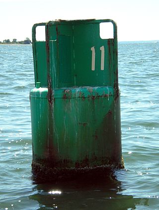
A buoy is a floating device that can have many purposes. It can be anchored (stationary) or allowed to drift with ocean currents.
Piloting or pilotage is the process of navigating on water or in the air using fixed points of reference on the sea or on land, usually with reference to a nautical chart or aeronautical chart to obtain a fix of the position of the vessel or aircraft with respect to a desired course or location. Horizontal fixes of position from known reference points may be obtained by sight or by radar. Vertical position may be obtained by depth sounder to determine depth of the water body below a vessel or by altimeter to determine an aircraft's altitude, from which its distance above the ground can be deduced. Piloting a vessel is usually practiced close to shore or on inland waterways. Pilotage of an aircraft is practiced under visual meteorological conditions for flight.
The International Association of Marine Aids to Navigation and Lighthouse Authorities (IALA), previously known as International Association of Lighthouse Authorities, is an association founded in 1957 to collect and provide nautical expertise and advice. IALA is also known by its French name of Association Internationale de Signalisation Maritime (AISM).

A lateral buoy, lateral post or lateral mark, as defined by the International Association of Marine Aids to Navigation and Lighthouse Authorities, is a sea mark used in maritime pilotage to indicate the edge of a channel.

A sector light is a man-made pilotage and position fixing aid that consists of strictly delineated horizontal angle light beams to guide water-borne traffic through a safe channel at night in reasonable visibility. Sector lights are most often used for safe passage through shallow or dangerous waters. This may be when leaving or entering harbour. Nautical charts give all the required information.
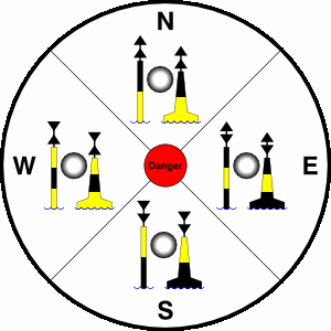
A cardinal mark is a sea mark commonly used in maritime pilotage to indicate the position of a hazard and the direction of safe water.

An Isolated Danger Mark, as defined by the International Association of Lighthouse Authorities, is a sea mark used in maritime pilotage to indicate a hazard to shipping such as a partially submerged rock.

A navigation light, also known as a running or position light, is a source of illumination on a watercraft, aircraft or spacecraft, meant to give information on the craft's position, heading, or status. Some navigation lights are colour-coded red and green to aid traffic control by identifying the craft's orientation. Their placement is mandated by international conventions or civil authorities such as the International Maritime Organization (IMO).

The Thames Estuary is where the River Thames meets the waters of the North Sea, in the south-east of Great Britain.
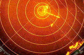
Radar beacon is – according to article 1.103 of the International Telecommunication Union's (ITU) ITU Radio Regulations (RR) – defined as "A transmitter-receiver associated with a fixed navigational mark which, when triggered by a radar, automatically returns a distinctive signal which can appear on the display of the triggering radar, providing range, bearing and identification information." Each station shall be classified by the service in which it operates permanently or temporarily.
MV Tricolor was a 50,000 tonne Norwegian-flagged vehicle carrier built in 1987, notable for having been involved in three English Channel collisions within a fortnight.

A day beacon is an unlighted nautical sea mark. A signboard identifying it is called a day mark. Day beacons typically mark channels whose key points are marked by lighted buoys. They may also mark smaller navigable routes in their entirety. They are the most common navigation aid in shallow water, as they are relatively inexpensive to install and maintain. Navigation around them is similar to that around other navigation aids.
A daymark is a navigational aid for sailors and pilots, distinctively marked to maximize its visibility in daylight.

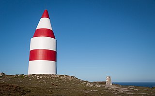
A navigational aid (NAVAID), also known as aid to navigation (ATON), is any sort of signal, markers or guidance equipment which aids the traveler in navigation, usually nautical or aviation travel. Common types of such aids include lighthouses, buoys, fog signals, and day beacons.
Captain John Bury was a master mariner and Elder Brother of Trinity House. He was involved in the adoption of a standardised buoyage system internationally.

Sailing Directions are written directions that describe the routes to be taken by boats and ships during coastal navigation and port approaches. There are also products known as Sailing Directions, which are books written by various Hydrographic Offices throughout the world. They are known as Pilot Books, because they provide local knowledge of routes and landmarks, which would typically be provided by a local marine pilot. As such, they are used frequently by naval and government vessels, who are exempted from 'Compulsory Pilotage' in many ports.

The North Bull Lighthouse, is an active aid to navigation located at the mouth of the River Liffey, near Dublin, Ireland. It is one of four lighthouses that help guide shipping into the Liffey, and the Port of Dublin, all of which are operated and maintained by the Dublin Port Company.
An ocean data acquisition system (ODAS) is a set of instruments deployed at sea to collect as much meteorological and oceanographic data as possible. With their sensors, these systems deliver data both on the state of the ocean itself and the surrounding lower atmosphere. The use of microelectronics and technologies with efficient energy consumption allows to increase the types and numbers of sensor deployed on a single device.

An Emergency wreck buoy is used to warn of a new wreck which has not yet been listed in maritime documents. The buoy is expected to be deployed for the first 24-72 hours after the wreck occurs. After that time more permanent buoyage should be deployed and charts updated.


