Special mark

Last updated
Examples of Special Marks IALA specjal mark.png
Examples of Special Marks
A Special mark indicating an outfall pipe in the Irish Sea off Helen's Bay, Northern Ireland. It has the flashing sequence Fl.(2).Y meaning it flashes yellow twice, this is called group flashing. Buoy off Seahill - geograph.org.uk - 720806.jpg
A Special mark indicating an outfall pipe in the Irish Sea off Helen's Bay, Northern Ireland. It has the flashing sequence Fl.(2).Y meaning it flashes yellow twice, this is called group flashing.

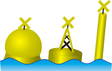
A Special Mark, as defined by the International Association of Lighthouse Authorities, is a sea mark used in maritime pilotage. It is recognisable by its yellow colour and X, (also referred to as a St. Andrews Cross or saltire) top-mark. It has a distinctive sequence of various flashes that does not match any other navigational mark flashes in its vicinity.

Contents

Purpose

Special marks can indicate:

Other uses

See also

Related Research Articles

<span class="mw-page-title-main">Buoy</span> Floating structure or device

A buoy is a floating device that can have many purposes. It can be anchored (stationary) or allowed to drift with ocean currents.

<span class="mw-page-title-main">River Derwent, Yorkshire</span> River in Yorkshire, England

The Derwent is a river in Yorkshire in the north of England. It flows from Fylingdales Moor in the North York Moors National Park, east then southwards as far as its confluence with the River Hertford then westwards through the Vale of Pickering, south through Kirkham Gorge and the Vale of York, joining the River Ouse at Barmby on the Marsh. The confluence is unusual in that the Derwent converges on the Ouse at a shallow angle in an upstream direction.

<span class="mw-page-title-main">Mooring</span> Any permanent structure to which a floating vessel may be secured to restrict movement on the water

A mooring is any permanent structure to which a vessel may be secured. Examples include quays, wharfs, jetties, piers, anchor buoys, and mooring buoys. A ship is secured to a mooring to forestall free movement of the ship on the water. An anchor mooring fixes a vessel's position relative to a point on the bottom of a waterway without connecting the vessel to shore. As a verb, mooring refers to the act of attaching a vessel to a mooring.

<span class="mw-page-title-main">Surface marker buoy</span> Buoy towed by a scuba diver to indicate the divers position

A surface marker buoy, SMB, dive float or simply a blob is a buoy used by scuba divers, at the end of a line from the diver, intended to indicate the diver's position to people at the surface while the diver is underwater. Two kinds are used; one (SMB) is towed for the whole dive, and indicates the position of the dive group throughout the dive, and the other, a delayed surface marker buoy, DSMB or decompression buoy, is deployed towards the end of the dive as a signal to the surface that the divers have started to ascend, and where they are going to surface. Both types can also function as a depth reference for controlling speed of ascent and accurately maintaining depth at decompression stops. Surface marker buoys are also used by freedivers in open water, to indicate the approximate position of the diver when submerged. They may also be used to support a catch bag or fish stringer by underwater hunters and collectors. A DSMB is considered by recreational scuba divers and service providers to be a highly important item of safety equipment, yet its use is not part of the entry level recreational diver training for all training agencies, and there are significant hazards associated with incompetent use.

The International Association of Marine Aids to Navigation and Lighthouse Authorities (IALA), previously known as International Association of Lighthouse Authorities, is an intergovernmental organization founded in 1957 to collect and provide nautical expertise and advice. IALA is also known by its French name of Association Internationale de Signalisation Maritime (AISM).

<span class="mw-page-title-main">Lateral mark</span> Sea mark marking the edge of a channel

A lateral buoy, lateral post or lateral mark, as defined by the International Association of Marine Aids to Navigation and Lighthouse Authorities, is a sea mark used in maritime pilotage to indicate the edge of a channel.

<span class="mw-page-title-main">Sea mark</span> Maritime navigation aid

A sea mark, also seamark and navigation mark, is a form of aid to navigation and pilotage that identifies the approximate position of a maritime channel, hazard, or administrative area to allow boats, ships, and seaplanes to navigate safely.

<span class="mw-page-title-main">Cardinal mark</span> Sea mark indicating where safe water is near to a hazard

A cardinal mark is a sea mark used in maritime pilotage to indicate the position of a hazard and the direction of safe water.

<span class="mw-page-title-main">Safe water mark</span> Type of sea mark

A safe water mark, as defined by the International Association of Lighthouse Authorities, is a sea mark used in maritime pilotage to indicate the end of a channel. They usually imply that open, deep and safe water lies ahead. They are also used to indicate the start and end of a buoyed section of a continuous narrow channel; and a series of them may mark a safe route through shallow areas. It is therefore important to consult appropriate charts to determine their meaning in each location. They are also known as fairway buoys and clear water buoys.

<span class="mw-page-title-main">Isolated danger mark</span> Sea mark indicating a danger spot

An Isolated Danger Mark, as defined by the International Association of Lighthouse Authorities, is a sea mark used in maritime pilotage to indicate a hazard to shipping such as a partially submerged rock.

<span class="mw-page-title-main">Light characteristic</span> Description of navigational light

A light characteristic is all of the properties that make a particular navigational light identifiable. Graphical and textual descriptions of navigational light sequences and colours are displayed on nautical charts and in Light Lists with the chart symbol for a lighthouse, lightvessel, buoy or sea mark with a light on it. Different lights use different colours, frequencies and light patterns, so mariners can identify which light they are seeing.

<span class="mw-page-title-main">Diver communications</span> Methods used by underwater divers to communicate

Diver communications are the methods used by divers to communicate with each other or with surface members of the dive team. In professional diving, diver communication is usually between a single working diver and the diving supervisor at the surface control point. This is considered important both for managing the diving work, and as a safety measure for monitoring the condition of the diver. The traditional method of communication was by line signals, but this has been superseded by voice communication, and line signals are now used in emergencies when voice communications have failed. Surface supplied divers often carry a closed circuit video camera on the helmet which allows the surface team to see what the diver is doing and to be involved in inspection tasks. This can also be used to transmit hand signals to the surface if voice communications fails. Underwater slates may be used to write text messages which can be shown to other divers, and there are some dive computers which allow a limited number of pre-programmed text messages to be sent through-water to other divers or surface personnel with compatible equipment.

<span class="mw-page-title-main">Runnel Stone</span>

The Runnel Stone, or Rundle Stone, is a hazardous rock pinnacle about 1-mile (1.6 km) south of Gwennap Head, Cornwall, United Kingdom. It used to show above the surface at low water until a steamship struck it in 1923.

Braye Harbour is the main harbour on the north side of the island of Alderney, in the Channel Islands, a dependency of the British Crown. A 3,000 feet (910 m) breakwater was built by the Admiralty to protect the Navy in the 19th century shelters Braye Harbour. The harbour faces out onto the Swinge, which is part of the English Channel, and it is at Braye that most of the island's freight comes in. Braye is more or less a suburb of St Anne, the island capital; the centre of St Anne lies approximately 1 mile from the harbour.

<span class="mw-page-title-main">Day beacon</span> Unlighted nautical sea mark

A day beacon is an unlighted nautical sea mark. A signboard identifying it is called a day mark. Day beacons typically mark channels whose key points are marked by lighted buoys. They may also mark smaller navigable routes in their entirety. They are the most common navigation aid in shallow water, as they are relatively inexpensive to install and maintain. Navigation around them is similar to that around other navigation aids.

<span class="mw-page-title-main">Canoe and kayak diving</span> Recreational diving from a canoe or kayak

Canoe diving and Kayak diving are recreational diving where the divers paddle to a diving site in a canoe or kayak carrying all their gear in or on the boat to the place they want to dive. Canoe or kayak diving gives the diver independence from dive boat operators, while allowing dives at sites which are too far to comfortably swim, but are sufficiently sheltered.

<span class="mw-page-title-main">Navigational aid</span> Marker to assist in safe passage making

A navigational aid (NAVAID), also known as aid to navigation (ATON), is any sort of signal, markers or guidance equipment which aids the traveler in navigation, usually nautical or aviation travel. Common types of such aids include lighthouses, buoys, fog signals, and day beacons.

<span class="mw-page-title-main">Weather buoy</span> Floating instrument package which collects weather and ocean data on the worlds oceans

Weather buoys are instruments which collect weather and ocean data within the world's oceans, as well as aid during emergency response to chemical spills, legal proceedings, and engineering design. Moored buoys have been in use since 1951, while drifting buoys have been used since 1979. Moored buoys are connected with the ocean bottom using either chains, nylon, or buoyant polypropylene. With the decline of the weather ship, they have taken a more primary role in measuring conditions over the open seas since the 1970s. During the 1980s and 1990s, a network of buoys in the central and eastern tropical Pacific Ocean helped study the El Niño-Southern Oscillation. Moored weather buoys range from 1.5–12 metres (5–40 ft) in diameter, while drifting buoys are smaller, with diameters of 30–40 centimetres (12–16 in). Drifting buoys are the dominant form of weather buoy in sheer number, with 1250 located worldwide. Wind data from buoys has smaller error than that from ships. There are differences in the values of sea surface temperature measurements between the two platforms as well, relating to the depth of the measurement and whether or not the water is heated by the ship which measures the quantity.

<span class="mw-page-title-main">Single buoy mooring</span> Offshore mooring buoy with connections for loading or unloading tankers

A Single buoy mooring (SrM) is a loading buoy anchored offshore, that serves as a mooring point and interconnect for tankers loading or offloading gas or liquid products. SPMs are the link between geostatic subsea manifold connections and weathervaning tankers. They are capable of handling any tonnage ship, even very large crude carriers (VLCC) where no alternative facility is available.

<span class="mw-page-title-main">Emergency wreck buoy</span> Marker buoy warning of a wreck

An Emergency wreck buoy is used to warn of a new wreck which has not yet been listed in maritime documents. The buoy is expected to be deployed for the first 24-72 hours after the wreck occurs. After that time more permanent buoyage should be deployed and charts updated.

References