Ameland is a municipality and one of the West Frisian Islands off the north coast of the Netherlands. It consists mostly of sand dunes. It is the third major island of the West Frisians. It neighbours islands Terschelling to the west and Schiermonnikoog to the east. This includes the small Engelsmanplaat and Rif sandbanks to the east.

Schiermonnikoog is an island, a municipality and national park in the Northern Netherlands. Schiermonnikoog is one of the West Frisian Islands, and is part of the province of Friesland. It is situated between the islands of Ameland and Rottumerplaat.

The Wadden Sea National Parks in Denmark, Germany and the Netherlands are located along the German Bight of the North Sea. In Germany and Denmark they also mark the area of the UNESCO World Heritage Site of the Wadden Sea. Divided from each other by administrative borders, they form a single ecological entity. The purpose of the national parks is the protection of the Wadden Sea ecoregion.
The West Frisian Islands are a chain of islands in the North Sea off the Dutch coast, along the edge of the Wadden Sea. They continue further east as the German East Frisian Islands and are part of the Frisian Islands.

The Frisian Islands, also known as the Wadden Islands or the Wadden Sea Islands, form an archipelago at the eastern edge of the North Sea in northwestern Europe, stretching from the northwest of the Netherlands through Germany to the west of Denmark. The islands shield the mudflat region of the Wadden Sea from the North Sea.

Oranjestad is a small town of 1,038 inhabitants; it is the capital of the island of Sint Eustatius in the Caribbean Netherlands.
North Tower may refer to:

The Brandaris is a lighthouse on the Dutch Wadden Sea island Terschelling, in Friesland. It is the oldest lighthouse in the Netherlands, listed as a Rijksmonument, number 35032 and rated with a very high historical value.
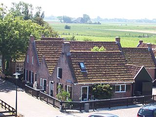
Moddergat is a fishing village in Noardeast-Fryslân in the province of Friesland, the Netherlands. It had a population of around 221 in January 2017. Before 2019, the village was part of the Dongeradeel municipality.
During World War II, the Netherlands was the scene of five years of continuous air warfare between the Allied and the Nazis as the Netherlands lies en route from England to Germany and was designated and built up as the foremost line of Nazi air defence of Germany. Also, in 1944 there was heavy land fighting during the largest Allied airborne attack of the WWII in the south and east of the country in 1944–45. Thousands of airmen, soldiers and others of many nations were killed, and their war graves in some 4,000 locations are in the care of the Dutch War Cemetery Organisation.

Lange Jaap, also known as Kijkduin Light or Den Helder Light, is an active lighthouse near Fort Kijkduin in Huisduinen, Netherlands. At a height of 63.5 metres (208.2 ft) it is one of the tallest "traditional lighthouses" in the world. For almost a century, from 1878 to 1974, it was the tallest lighthouse in the Netherlands, until the construction of the Maasvlakte Light. According to The Lighthouse Directory it is the tallest non-skeletal cast iron lighthouse in the world.

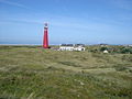
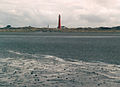
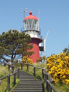
The Ameland Lighthouse, commonly known as Bornrif, is a lighthouse on the Dutch island Ameland, one of the Frisian Islands, on the edge of the North Sea. It was built in 1880 by order of William III of the Netherlands. It was designed by Dutch lighthouse architect Quirinus Harder and built by the foundry Nering Bögel in Deventer. The individual segments were shipped to Ameland and welded together on-site.
Vuurduin is a lighthouse on the Dutch island Vlieland. The tower is the top part of the former front light of the leading lights in IJmuiden, designed by Quirinus Harder.

The Eierland Lighthouse is a lighthouse on the northernmost tip of the Dutch island of Texel. It is named for the former island Eierland.

The J.C.J. van Speijk Lighthouse is a lighthouse on the North Sea coast near Egmond aan Zee, in the municipality of Bergen, North Holland, in the Netherlands. The foundation of the lighthouse, shaped like a tomb, is the official Dutch memorial to Jan van Speyk, a hero to the Dutch people.

Monnikenlangenoog, also called Moenkelangenoe, was a West Frisian island in the Wadden Sea. It was situated off the coast of present-day Groningen in the Netherlands, between the islands of Schiermonnikoog and Borkum.

Lauwersoog is a seaside village and harbour in the province of Groningen, located in the northern part of the Netherlands. It is part of the municipality of Het Hogeland. It was established on 23 May 1969. The ferry to Schiermonnikoog departs from Lauwersoog.
The West Frisian languages are a group of closely related, though not mutually intelligible, Frisian languages of the Netherlands. Due to the marginalization of all but mainland West Frisian, they are often portrayed as dialects of a single language.

Berthold Hartwig Arthur, Graf von Bernstorff was a German politician, forester and landowner. He served in the Reichstag from 1893 until 1907. In 1893, he bought the Dutch island of Schiermonnikoog.