Nautical publications is a technical term used in maritime circles describing a set of publications, either published by national governments or by commercial and professional organisations, for use in safe navigation of ships, boats, and similar vessels. Other publications might cover topics such as seamanship and cargo operations. In the UK, the United Kingdom Hydrographic Office, the Witherby Publishing Group and the Nautical Institute provide numerous navigational publications, including charts, publications on how to navigate and passage planning publications. In the US, publications are issued by the US government and US Coast Guard.

Chipiona Lighthouse, also known as Punta del Perro Light, is an active 19th-century lighthouse in Chipiona, in the province of Cádiz, Spain. At a height of 205 feet (62 m) it is the seventeenth tallest "traditional lighthouse" in the world, as well as the tallest in Spain. It is located on Punta del Perro, a projection of land into the Atlantic Ocean in the city of Chipiona, about 6 kilometres (3.7 mi) southwest of the Guadalquivir entrance, and serves as the landfall light for Seville.

The Ponta das Contendas Lighthouse is lighthouse located along the promontory of Contendas, in the civil parish of São Sebastião, municipality of Angra do Heroísmo on the island of Terceira, in the Portuguese archipelago of the Azores.

The Europa Point Lighthouse, also referred to as the Trinity Lighthouse at Europa Point and the Victoria Tower or La Farola in Llanito, is a lighthouse at Europa Point, on the southeastern tip of the British Overseas Territory of Gibraltar, on the southern end of the Iberian Peninsula, at the entrance to the Mediterranean Sea.

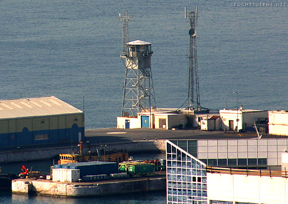
The Gibraltar North Mole Lighthouse is one of several lighthouses in Gibraltar, the British Overseas Territory at the southern end of the Iberian Peninsula. Also referred to as the Gibraltar "D" Head Lighthouse, its cast-iron tower is painted black. The active lighthouse west of the Rock of Gibraltar is positioned on the Western Arm of the North Mole at Gibraltar Harbour, and is operated by the Gibraltar Port Authority.
The Gibraltar South Mole Lighthouse is one of several lighthouses in Gibraltar, a British Overseas Territory at the south end of the Iberian Peninsula. Also known as the Gibraltar "A" Head Lighthouse, it has a cast-iron, skeletal tower which is painted black and features two galleries. The lighthouse remains operational and is positioned west of the Rock of Gibraltar, on the South Mole at Gibraltar Harbour. It is operated by the Gibraltar Port Authority.
The Gibraltar North Mole Elbow Lighthouse is one of several lighthouses in Gibraltar, a British Overseas Territory at the south end of the peninsula of Iberia. Also known as the Gibraltar "E" Head Lighthouse, its tower is painted grey. The active lighthouse is west of the Rock of Gibraltar and positioned at the elbow of the North Mole at Gibraltar Harbour. The lighthouse is operated by the Gibraltar Port Authority.
The Gibraltar Aerobeacon built in 1841 is one of several lighthouses in Gibraltar, the British Overseas Territory at the southern end of the Iberian Peninsula. It is also known as the Gibraltar Aviation Light and Gibraltar Aero Light. The active beacon is positioned atop the Rock of Gibraltar and is operated by the Government of Gibraltar.

The South Mole is a breakwater located in the southern section of Gibraltar Harbour, in the British Overseas Territory of Gibraltar, at the southern end of the Iberian Peninsula. Previously known as the New Mole and New Mole Extension, the South Mole, with the rest of harbour, is just north of the east entrance to the Strait of Gibraltar.

The Detached Mole is a breakwater located at the western aspect of the middle section of Gibraltar Harbour, in the British Overseas Territory of Gibraltar, at the southern end of the Iberian Peninsula. The Detached Mole, with the rest of harbour, is just north of the east entrance to the Strait of Gibraltar and was the site of the Detached Mole Battery. In addition to the role the breakwater plays in the defence of and access to the harbour, the Detached Mole provides berths for ships. The area adjacent to the mole is also a source of recreational and research opportunities, with dive sites at the wrecks of sunken ships.
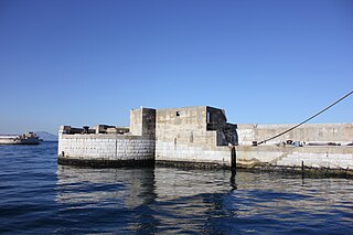
The Gibraltar Detached Mole Lighthouse is one of several lighthouses in Gibraltar, a British Overseas Territory at the south end of the Iberian Peninsula. The lighthouse is positioned west of the Rock of Gibraltar, on the Detached Mole at the south entrance to Gibraltar Harbour.
The Gibraltar Detached Mole Lighthouse is one of several lighthouses in Gibraltar, a British Overseas Territory at the south end of the Iberian Peninsula. The lighthouse is positioned west of the Rock of Gibraltar, on the Detached Mole at the north entrance to Gibraltar Harbour.

The North Mole is a breakwater located in the northern section of Gibraltar Harbour, in the British Overseas Territory of Gibraltar, at the southern end of the Iberian Peninsula. The North Mole, with the rest of harbour, is just north of the east entrance to the Strait of Gibraltar. The breakwater was formerly known as the Commercial Mole, and is the site of the commercial port in the harbour. It was the consequence of a late nineteenth century plan by the British Admiralty to create a modern dockyard and large defensive harbour in Gibraltar.

The Guia lighthouse is an active Portuguese lighthouse located at Cabo da Guia, about 2 km west of the centre of Cascais. It is an octagonal tower in white masonry with a red lantern that has a range of 18 nautical miles.

The El Hank lighthouse is a lighthouse located on the tip of El Hank, west of the port of Casablanca. It is managed by the Port and Maritime Authority within the Ministry of Equipment, Transport, Logistics and Water.

The French Pass Lighthouse together with a stone beacon mark a channel through the turbulent waters between Rangitoto ki te Tonga / D’Urville Island and the South Island. The New Zealand List of Lights calls the lighthouse Channel Point.


