Detached Mole, Gibraltar Harbour

Last updated
Gibraltar Harbour with North Mole, Detached Mole, and South Mole Gibraltar map-en-edit2.svg
Gibraltar Harbour with North Mole, Detached Mole, and South Mole
Gibraltar Harbour with South Mole (left), Detached Mole (center), and North Mole with Western Arm (right) Bay of Gibraltar from The Rock 4.JPG
Gibraltar Harbour with South Mole (left), Detached Mole (center), and North Mole with Western Arm (right)
The Detached Mole as shown on a map published in 1911 Gibraltar-1911 Encyclopedia bw.jpg
The Detached Mole as shown on a map published in 1911

The Detached Mole is a breakwater located at the western aspect of the middle section of Gibraltar Harbour, in the British Overseas Territory of Gibraltar, at the southern end of the Iberian Peninsula. The Detached Mole, with the rest of harbour, is just north of the east entrance to the Strait of Gibraltar and was the site of the Detached Mole Battery. In addition to the role the breakwater plays in the defence of and access to the harbour, the Detached Mole provides berths for ships. The area adjacent to the mole is also a source of recreational and research opportunities, with dive sites at the wrecks of sunken ships. Coordinates: 36°07′47″N5°21′37″W / 36.1297°N 5.3603°W / 36.1297; -5.3603

History

1920 US Navy Information - Detached Mole. - From a position 0°, 200 yards from the outer end of South Mole a detached mole extends 910 yards 339°; between its northern end and the southern extremity of the arm of North Mole, which bears 39° from it, is the northern entrance to the harbour, 220 yards wide. There are 2,600 feet of berthing accommodation on the eastern side of the Detached Mole suitable for large vessels.

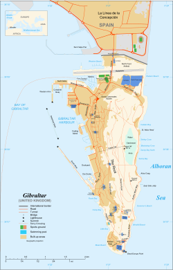
The Detached Mole at Gibraltar Harbour, is one of a trio of breakwaters that provides protection to the harbour, in addition to the protection resulting from the presence of the Rock of Gibraltar itself on the east side of the harbour. [1] The Detached Mole is positioned at the western aspect of the middle section of the harbour, [1] [2] which is located just north of the east entrance to the Strait of Gibraltar. [3] The Detached Mole is 800 metres in length. Yachting facilities, including the Queensway Quay Marina, are also in the middle section of the harbour. [1] The marina is privately owned and contains 160 berths for yachts. That section of the harbour is also home to Cormorant Camber and the Coaling Island quay. [4]

The south end of the Detached Mole, its "B" Head, is the site of the Gibraltar Detached Mole ("B" Head) Lighthouse. Its light characteristic is a quick, flashing red light, and it has a range of 5 nmi (9.3 km). The north end of the Detached Mole, its "C" Head, is the site of the Gibraltar Detached Mole ("C" Head) Lighthouse. The light characteristic is a quick, flashing green light, with a range of 5 nmi (9.3 km). [5] [6] [7]

The south entrance to Gibraltar Harbour, between the "A" Head of the South Mole and the "B" Head of the Detached Mole, is controlled by the Queen's Harbourmaster. Commercial boats typically use the north entrance to the harbour, between the "C" Head of the Detached Mole and the "D" Head of the Western Arm of the North Mole. Berths utilised by U.S. Navy ships on the Detached Mole include Piers 51 and 52. [3] [8]

The Detached Mole was constructed of concrete blocks, each weighing 28 tons. The wall was built upon a foundation of rubble stone that was first deposited by barges and then leveled by divers before the placement of the concrete blocks. [2] The Detached Mole was begun before 1888 and completed in 1901. [9] [10] It is of more recent vintage than the South Mole which was first constructed in the early seventeenth century (1620) as the New Mole, to distinguish it from the Old Mole. The North Mole, formerly known as the Commercial Mole, was a late nineteenth and early twentieth century [2] extension of the Old Mole (begun in 1618) [11] and its extension, the Devil's Tonque (constructed 1779–1783). [2]

In 1888, the Excellent sank off the Detached Mole after several collisions. The wreck has split in two, and the ship is upside down on the sea bed. The wreck of the steel-clad steamship is now a popular dive site. [9] [12] On 18 January 1942, the HMT Erin, an anti-submarine trawler, was sunk by an explosion in Gibraltar Harbour. The HMT Imperialist and HMT Honjo were also severely damaged. It was eventually learned that the explosion on the Erin was the result of sabotage. A Spaniard who worked in the naval dockyard had packed a bomb inside one of the ship's depth charges. It is believed that the remains of the trawler were dragged through the north entrance to the harbour and dumped outside the Detached Mole. The "Inner and Outer" are two popular dive sites located off the Detached Mole. Both are felt to represent the remains of the HMT Erin. [10] The first annual "Adopt a Wreck" Award was made in 2003 to the Gibraltar Museum's Underwater Research Unit and the Joint Services Dive Club for their work off Gibraltar's detached mole. [13] It was in recognition of their research of the "Inner and Outer" sites. This annual award is given to the individual or group who has made the most substantial "contribution to maritime archaeology and research through the adoption process." [13]

The ownership of the Detached Mole passed from the UK Ministry of Defence to be completely owned by the Government of Gibraltar in 2011. [14]

Related Research Articles

Saint Peter Port Harbour Port Harbour located in Guernsey

Saint Peter Port Harbour is located in Saint Peter Port, Guernsey. It was a natural anchorage used by the Romans which has been changed into an artificial harbour that is now the island's main port for passengers. Loose cargo, liquids and gas are shipped to and from St Sampson's harbour.

Ashland Harbor Breakwater Light

The Ashland Harbor Breakwater lighthouse, also known as Ashland Breakwater Lighthouse, is an operational lighthouse located near Ashland in Ashland County, Wisconsin, USA. Located in Chequamegon Bay of Lake Superior, it is owned and managed by the U.S. Coast Guard. It sits at the end of a long and detached breakwater, which creates an artificial harbor.

Fairport Harbor West Breakwater Light Lighthouse in Ohio, United States

The Fairport Harbor West Breakwater Light, on Lake Erie, located near the end of the west breakwater at the mouth of the Grand River was built in 1925, replacing the Grand River Light, which still stands and is now a marine museum.

Port of Ramsgate

The Port of Ramsgate is a harbour situated in Ramsgate, south-east England, serving cross-Channel freight traffic and smaller working and pleasure craft. It is owned and operated by Thanet District Council.

Fremantle Harbour

Fremantle Harbour is Western Australia's largest and busiest general cargo port and an important historical site. The inner harbour handles a large volume of sea containers, vehicle imports and livestock exports, cruise shipping and naval visits, and operates 24 hours a day. It is located adjacent to the city of Fremantle, in the Perth metropolitan region.

Pasig River Light

The Pasig River Light was the first light station in the Philippines when it was established in 1642. The first lighthouse tower in the country was erected in the station and first lit in 1846. It was then located on the north jetty at the mouth of Pasig River in San Nicolas, Manila, marking the entrance of the river for vessels cruising Manila Bay, looking to dock on the inland Port of Manila that was then located along the banks of the Pasig River in Binondo and Intramuros.

Gibraltar North Mole Lighthouse

The Gibraltar North Mole Lighthouse is one of several lighthouses in Gibraltar, the British Overseas Territory at the southern end of the Iberian Peninsula. Also referred to as the Gibraltar "D" Head Lighthouse, its cast-iron tower is painted black. The active lighthouse west of the Rock of Gibraltar is positioned on the Western Arm of the North Mole at Gibraltar Harbour, and is operated by the Gibraltar Port Authority.

Gibraltar South Mole Lighthouse

The Gibraltar South Mole Lighthouse is one of several lighthouses in Gibraltar, a British Overseas Territory at the south end of the Iberian Peninsula. Also known as the Gibraltar "A" Head Lighthouse, it has a cast-iron, skeletal tower which is painted black and features two galleries. The lighthouse remains operational and is positioned west of the Rock of Gibraltar, on the South Mole at Gibraltar Harbour. It is operated by the Gibraltar Port Authority.

Gibraltar North Mole Elbow Lighthouse

The Gibraltar North Mole Elbow Lighthouse is one of several lighthouses in Gibraltar, a British Overseas Territory at the south end of the peninsula of Iberia. Also known as the Gibraltar "E" Head Lighthouse, its tower is painted grey. The active lighthouse is west of the Rock of Gibraltar and positioned at the elbow of the North Mole at Gibraltar Harbour. The lighthouse is operated by the Gibraltar Port Authority.

South Mole, Gibraltar Harbour

The South Mole is a breakwater located in the southern section of Gibraltar Harbour, in the British Overseas Territory of Gibraltar, at the southern end of the Iberian Peninsula. Previously known as the New Mole and New Mole Extension, the South Mole, with the rest of harbour, is just north of the east entrance to the Strait of Gibraltar.

Gibraltar Detached Mole ("B" Head) Lighthouse

The Gibraltar Detached Mole Lighthouse is one of several lighthouses in Gibraltar, a British Overseas Territory at the south end of the Iberian Peninsula. The lighthouse is positioned west of the Rock of Gibraltar, on the Detached Mole at the south entrance to Gibraltar Harbour.

Gibraltar Detached Mole ("C" Head) Lighthouse

The Gibraltar Detached Mole Lighthouse is one of several lighthouses in Gibraltar, a British Overseas Territory at the south end of the Iberian Peninsula. The lighthouse is positioned west of the Rock of Gibraltar, on the Detached Mole at the north entrance to Gibraltar Harbour.

North Mole, Gibraltar Harbour

The North Mole is a breakwater located in the northern section of Gibraltar Harbour, in the British Overseas Territory of Gibraltar, at the southern end of the Iberian Peninsula. The North Mole, with the rest of harbour, is just north of the east entrance to the Strait of Gibraltar. The breakwater was formerly known as the Commercial Mole, and is the site of the commercial port in the harbour. It was the consequence of a late nineteenth century plan by the British Admiralty to create a modern dockyard and large defensive harbour in Gibraltar.

Queensway Quay Marina, Gibraltar

The Queensway Quay Marina is one of three marinas in the British Overseas Territory of Gibraltar, at the southern end of the Iberian Peninsula. The yachting facility is located at the eastern aspect of the middle section of Gibraltar Harbour. It is the site of what may be the oldest wharf in Gibraltar, Ragged Staff Wharf.

Gibraltar Cruise Terminal

The Gibraltar Cruise Terminal is located at the northern end of the Western Arm of the North Mole at Gibraltar Harbour. Construction of the facility in the British Overseas Territory of Gibraltar was completed in 1997. In the fifteen years since its opening, the terminal handled approximately three million cruise passengers. In May 2011, the explosion of a sullage tank on the Western Arm, while a cruise ship was berthed nearby, ultimately resulted in the loss of life of a dock worker. In October 2011, the Government of Gibraltar announced plans for expansion and renovation of the cruise terminal.

Farol de D. Maria Pia

Farol de Dona Maria Pia is a lighthouse at the southernmost point of the island of Santiago, Cape Verde. It stands on the headland Ponta Temerosa, at the entrance of Praia Harbour, 2 km south of the city centre of Praia. The lighthouse was built in 1881 and was named after Maria Pia of Savoy, queen of Portugal at the time. The octagonal tower is 21 m high and its focal plane is 25 m above mean sea level. It is painted white. The lighthouse is used for navigational purposes.

Marubi Palace Gardens Range Rear Lighthouse

The Marubi Palace Gardens Range Rear Lighthouse is located in the Marubi Palace Gardens in Stone Town, Zanzibar, Tanzania. The lighthouse is located to support ships trying to dock at the Stone Town harbor.

Ponta do Altar Lighthouse Lighthouse near Ferragudo, Portugal

The Ponta do Altar Lighthouse is located in the Ferragudo parish of the Lagoa municipality in the Faro District of Portugal.

References

  1. 1 2 3 "An Outline of the Port Infrastructure". Port of Gibraltar Handbook 2010-11. Land & Marine Publications Ltd, on behalf of the Gibraltar Port Authority. 2010. p. 13. Retrieved 1 August 2012.
  2. 1 2 3 4 Mitchell, Hugh (1911). "Gibraltar"  . In Chisholm, Hugh (ed.). Encyclopædia Britannica . 11 (11th ed.). Cambridge University Press. p. 941.
  3. 1 2 "Military - Gibraltar". globalsecurity.org. GlobalSecurity.org. Retrieved 1 August 2012.
  4. "General Description of the Port". Port of Gibraltar Handbook 2010-11. Land & Marine Publications Ltd, on behalf of the Gibraltar Port Authority. 2010. p. 63. Retrieved 1 August 2012.
  5. "Publication 113 - List of Lights, Radio Aids, and Fog Signals" (PDF). msi.nga.mil. United States National Geospatial-Intelligence Agency. 2011. p. XI-XIII and 71. Archived from the original (PDF) on 31 July 2017. Retrieved 1 August 2012.
  6. "Gibraltar". trabas.de. The Online List of Lights. Archived from the original on 17 January 2012. Retrieved 1 August 2012.
  7. "ARLHS World List of Lights (WLOL) - Gibraltar". wlol.arlhs.com. Amateur Radio Lighthouse Society. Retrieved 1 August 2012.
  8. "Port of Gibraltar - Port Map". gibraltarport.com. Gibraltar Port Authority. 2011. Retrieved 4 August 2012.[ dead link ]
  9. 1 2 "Southern Europe / The Mediterranean - Gibraltar". bsac.com. British Sub-Aqua Club. Retrieved 2 August 2012.
  10. 1 2 "Detached Mole, Gibraltar Harbour". nauticalarchaeologysociety.org. Nautical Archaeology Society. Archived from the original on 15 April 2013. Retrieved 2 August 2012.
  11. United States Hydrographic Office (1916). Mediterranean pilot, Volume 1. U.S. G.P.O. p. 111. Retrieved 2 August 2012.
  12. Andrew Purvis (1 March 2012). "Top 10 dive sites". National Geographic Traveller. Retrieved 2 August 2012.
  13. 1 2 "Annual awards". nauticalarchaeologysociety.org. Nautical Archaeology Society. Archived from the original on 2 September 2010. Retrieved 2 August 2012.
  14. "Government announces details of the recent Lands Agreement with MOD". 29 July 2011. Government of Gibraltar. Archived from the original on 13 November 2012. Retrieved 1 May 2013.