Related Research Articles
Gibdock is a shipyard in the British overseas territory of Gibraltar. It formerly operated as a Royal Navy Dockyard.
Lothbury was an authorised underground railway station planned by the Great Northern & City Railway (GN&CR) but never built. It was to be located in Lothbury, in the City of London, the historic nucleus and financial centre of London.
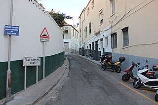
Flat Bastion Road is a road in Gibraltar, the British Overseas Territory at the southern end of the Iberian Peninsula. The road runs north-south, providing views of the city and Bay of Gibraltar. Previously known in Spanish as Senda del Moro, the traditional Llanito name for the road is Cuesta de Mr. Bourne.

The Gibraltar–Spain border is the international boundary between the British Overseas Territory of Gibraltar and the Kingdom of Spain. It is also referred to as "The Fence of Gibraltar" or simply "The Fence".

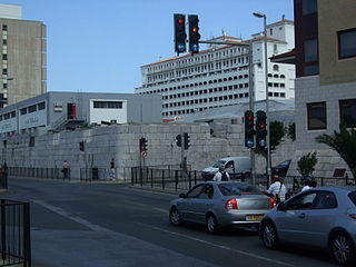
Flat Bastion is a bastion which projects southward from the Charles V Wall in the British Overseas Territory of Gibraltar. Once known as the St. Jago's Bastion or the Baluarte de Santiago in Spanish, the fortification was built by the Spanish in the mid 16th century and formed part of the southern defences of the city of Gibraltar, together with Charles V Wall, Southport Gates, Southport Ditch, and South Bastion. In 1859, six guns, four 12-pounders and two 12-pound carronades, were installed on the bastion, and four years later, five 32-pounders were mounted on the fortification.

The history of Moorish Gibraltar began with the landing of the Muslims in Hispania and the fall of the Visigothic Kingdom of Toledo in 711 and ended with the fall of Gibraltar to Christian hands 751 years later, in 1462, with an interregnum during the early 14th century.

The Moorish Wall, also known as the Philip II Wall and formerly the Muralla de San Reymondo is a defensive curtain wall built in the 16th century that formed part of the southern fortifications of the British Overseas Territory of Gibraltar. It was completed by 1575. The wall ran from the top of a steep cliff above the lower section of the Charles V Wall up the slope of the Rock of Gibraltar to its crest, north of the upper section of the Charles V Wall and is now within the Upper Rock Nature Reserve.
The Ninth Siege of Gibraltar was a fifteen-month-long siege of the town of Gibraltar that lasted from 1466 until 1467. The siege was conducted by Juan Alonso de Guzmán, the 1st Duke of Medina Sidonia, and resulted in a takeover of the town, then belonging to the Crown of Castile. Unlike other sieges of Gibraltar, which were the result of clashes between different powers, this was a purely internal struggle between rival Castilian factions.

Coaling Island is an area of reclaimed land in the British Overseas Territory of Gibraltar. It is located at the centre of the western end of Gibraltar Harbour as one of its industrial zones. It also serves to harbour Cormorant Camber which berths small boats. The Royal Gibraltar Yacht Club was located there after the Ministry of Defence Boat Squadron freed up the site.
Queensway is a main coastal road in the British Overseas Territory of Gibraltar and the only road servicing the oldest leisure marina on The Rock, Queensway Quay. It connects the marina with the industrial park in the southern end of the Gibraltar Harbour.
Ragged Staff Cave is a cave bordering the harbour in the British Overseas Territory of Gibraltar. The cave was converted into Ragged Staff Magazine in 1901.

Wellington Front is a fortification in the British Overseas Territory of Gibraltar. It was built in 1840 on a site established by the Spanish in 1618.

Jumper's Bastion may refer to one of two adjacent bastions in the British Overseas Territory of Gibraltar. They were both created in 1785 on the sites of previous constructions and named for a British Captain who was one on the first on shore during the Capture of Gibraltar in 1704.

Ragged Staff Gates are a set of city gates in the British Overseas Territory of Gibraltar. They are located between South Bastion and Ragged Staff Guard, opposite the Navy Boat Sheds.

The fortifications of Gibraltar have made the Rock of Gibraltar and its environs "probably the most fought over and most densely fortified place in Europe, and probably, therefore, in the world", as Field Marshal Sir John Chapple has put it. The Gibraltar peninsula, located at the far southern end of Iberia, has great strategic importance as a result of its position by the Strait of Gibraltar where the Mediterranean Sea meets the Atlantic Ocean. It has repeatedly been contested between European and North African powers and has endured fourteen sieges since it was first settled in the 11th century. The peninsula's occupants – Moors, Spanish, and British – have built successive layers of fortifications and defences including walls, bastions, casemates, gun batteries, magazines, tunnels and galleries. At their peak in 1865, the fortifications housed around 681 guns mounted in 110 batteries and positions, guarding all land and sea approaches to Gibraltar. The fortifications continued to be in military use until as late as the 1970s and by the time tunnelling ceased in the late 1960s, over 34 miles (55 km) of galleries had been dug in an area of only 2.6 square miles (6.7 km2).

The Great North Road is a large road tunnel in the British Overseas Territory of Gibraltar. It was constructed by the British military during World War II inside the Rock of Gibraltar and remains property of the Ministry of Defence to this day. The road allowed lorries to travel from the north to the south of Gibraltar entirely within the Rock. The tunnel still contains the remains of World War II buildings such as Nissen huts, kitchens, offices as well as a generating station and period anti-submarine nets.

The Inundation was a flooded and fortified area of ground on the sandy isthmus between Spain and Gibraltar, created by the British in the 18th century to restrict access to the territory as part of the fortifications of Gibraltar. It was originally a marshy area known as the Morass at the far south-western end of the isthmus, occupying the area adjacent to the north-western flank of the Rock of Gibraltar. The Morass was dug out and expanded to create an artificial lake which was further obstructed by iron and wooden obstacles in the water. Two small fortifications on either side controlled access to Gibraltar. The only road to and from the town ran along a narrow causeway between the Inundation and the sea which was enfiladed by batteries mounted on the lower slopes of the Rock. The Inundation existed for about 200 years before it was infilled and built over after the Second World War.
Ragged Staff Flank is a masonry fortification on the South Front of Gibraltar's fortifications. It continues the line of the South Bastion's seaward face across the South Front ditch, then turns to form a flanking position facing south along the coastal fortifications leading to the New Mole. The Ragged Staff Gates were situated in the middle of the flank, leading to the Ordnance Wharf that was located where the Dockyard North Gate used to stand. A defended enclosure stood behind the gate, secured by the Ragged Staff Guardhouse. The flank position had three embrasures in its parapet but only mounted two 24-pdr guns in 1779, though these were replaced by 32-pdrs under the rearmament plan of 1859.

Mediterranean Steps is a path and nature trail in the British Overseas Territory of Gibraltar. One of the footpaths of Gibraltar, the path is located entirely within the Upper Rock Nature Reserve and was built by the British military but is now used by civilians as a pedestrian route linking Martin's Path to Lord Airey's Battery near the summit of Rock of Gibraltar. The path offers views over the Strait of Gibraltar, Windmill Hill, Europa Point, the Great Sand Dune, Gibraltar's east side beaches, the Mediterranean Sea and the Spanish Costa del Sol.

Windmill Hill or Windmill Hill Flats is one of a pair of plateaux, known collectively as the Southern Plateaux, at the southern end of the British Overseas Territory of Gibraltar. It is located just to the south of the Rock of Gibraltar, which descends steeply to the plateau. Windmill Hill slopes down gently to the south with a height varying from 120 metres (390 ft) at the north end to 90 metres (300 ft) at the south end. It covers an area of about 19 hectares, though about 6 hectares at the north end is built over. The plateau is ringed to the south and east with a line of cliffs which descend to the second of the Southern Plateaux, Europa Flats, which is itself ringed by sea cliffs. Both plateaux are the product of marine erosion during the Quaternary period and subsequent tectonic uplift. Windmill Hill was originally on the shoreline and its cliffs were cut by the action of waves, before the ground was uplifted and the shoreline moved further out to the edge of what is now Europa Flats.
References
-
 This article incorporates text from a publication now in the public domain : J. Onwhyn's The Lancet (1830)
- ↑ Fa & Finlayson (2006). The Fortifications of Gibraltar 1068-1945. Osprey Publishing. p. 56. ISBN 978-1-84603-016-1 . Retrieved 9 May 2013.
- ↑ Patterson, John (1840). Camp and quarters: impressions. p. 198.
ragged staff guard.
- ↑ The Lancet. J. Onwhyn. 1830. p. 420. Retrieved 9 May 2013.
Coordinates: 36°08′03″N5°21′13″W / 36.1342°N 5.3536°W
| | This Gibraltar-related article is a stub. You can help Wikipedia by expanding it. |