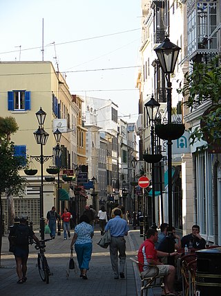
Main Street is the main arterial street in the British overseas territory of Gibraltar.

The Great Siege of Gibraltar was an unsuccessful attempt by Spain and France to capture Gibraltar from the British during the War of the American Revolution. It was the largest battle in the war by number of combatants.
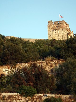
The Moorish Castle is the name given to a medieval fortification in Gibraltar comprising various buildings, gates, and fortified walls, with the dominant features being the Tower of Homage and the Gate House. Part of the castle itself also housed the prison of Gibraltar until it was relocated in 2010. The Tower of Homage is clearly visible to all visitors to Gibraltar; not only because of its striking construction, but also because of its dominant and strategic position. Although sometimes compared to the nearby alcazars in Spain, the Moorish Castle in Gibraltar was constructed by the Marinid dynasty, making it unique in the Iberian Peninsula.
The Line Wall Curtain is a defensive curtain wall that forms part of the fortifications of the British Overseas Territory of Gibraltar.

The Charles V Wall is a 16th-century defensive curtain wall that forms part of the fortifications of the British Overseas Territory of Gibraltar. Originally called Muralla de San Benito, it was built in 1540 and strengthened in 1552 by Holy Roman Emperor Charles V. The wall remains largely intact and extends from South Bastion, which was once at the water's edge in the harbour, to the top ridge of the Rock of Gibraltar.

Grand Casemates Gates, formerly Waterport Gate, provide an entrance from the northwest to the old, fortified portion of the city of the British Overseas Territory of Gibraltar, at Grand Casemates Square.

The South Bastion was part of the fortifications of Gibraltar, protecting the western base of the Charles V Wall. It was originally built by Spanish military engineers, later improved by the British. The South Bastion stands at the south end of the Line Wall Curtain which defends the town from attack from the Bay of Gibraltar. Another curtain wall runs east from the bastion to the base of a precipice. This wall is pierced by the Southport Gates, guarded by the South Bastion and the Flat Bastion on either side.

The history of Moorish Gibraltar began with the landing of the Muslims in Hispania and the fall of the Visigothic Kingdom of Toledo in 711 and ended with the fall of Gibraltar to Christian hands 751 years later, in 1462, with an interregnum during the early 14th century.

The Moorish Wall, also known as the Philip II Wall and formerly the Muralla de San Reymondo is a defensive curtain wall built in the 16th century that formed part of the southern fortifications of the British Overseas Territory of Gibraltar. It was completed by 1575. The wall ran from the top of a steep cliff above the lower section of the Charles V Wall up the slope of the Rock of Gibraltar to its crest, north of the upper section of the Charles V Wall and is now within the Upper Rock Nature Reserve.

The North Bastion, formerly the Baluarte San Pablo was part of the fortifications of Gibraltar, in the north of the peninsula, protecting the town against attack from the mainland of Spain. The bastion was based on the older Giralda tower, built in 1309. The bastion, with a mole that extended into the Bay of Gibraltar to the west and a curtain wall stretching to the Rock of Gibraltar on its east, was a key element in the defenses of the peninsula. After the British took Gibraltar in 1704 they further strengthened these fortifications, flooding the land in front and turning the curtain wall into the Grand Battery.
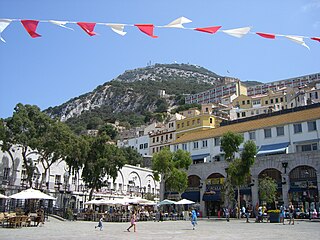
Grand Casemates Square is the larger of the two main squares within the city centre of Gibraltar. The square takes its name from the British-built Grand Casemates, a casemate and bombproof barracks at the northern end of the square completed in 1817.

Wellington Front is a fortification in the British Overseas Territory of Gibraltar. It was built in 1840 on a site established by the Spanish in 1618.

Hesse's Demi Bastion is a demi-bastion in the British Overseas Territory of Gibraltar. It is part of the Northern Defences of Gibraltar. The bastion forms a link in a chain of fortifications which ascend the lower north-west slopes of the Rock of Gibraltar, below the King's Lines Battery and Bombproof Battery. The Moorish Castle's Tower of Homage is at the top of the same incline.
Jones' Battery is one of the best preserved of the "retired" artillery battery in the British Overseas Territory of Gibraltar. It was named after Sir John Thomas Jones who once controlled the fortifications here.

Zoca Flank Battery is an artillery battery on the west side of the British Overseas Territory of Gibraltar.

The Gibraltar peninsula, located at the far southern end of Iberia, has great strategic importance as a result of its position by the Strait of Gibraltar where the Mediterranean Sea meets the Atlantic Ocean. It has repeatedly been contested between European and North African powers and has endured fourteen sieges since it was first settled in the 11th century. The peninsula's occupants – Moors, Spanish, and British – have built successive layers of fortifications and defences including walls, bastions, casemates, gun batteries, magazines, tunnels and galleries. At their peak in 1865, the fortifications housed around 681 guns mounted in 110 batteries and positions, guarding all land and sea approaches to Gibraltar. The fortifications continued to be in military use until as late as the 1970s and by the time tunnelling ceased in the late 1960s, over 34 miles (55 km) of galleries had been dug in an area of only 2.6 square miles (6.7 km2).

The King's Lines are a walled rock-cut trench on the lower slopes of the north-west face of the Rock of Gibraltar. Forming part of the Northern Defences of the fortifications of Gibraltar, they were originally created some time during the periods when Gibraltar was under the control of the Moors or Spanish. They are depicted in a 1627 map by Don Luis Bravo de Acuña, which shows their parapet following a tenaille trace. The lines seem to have been altered subsequently, as maps from the start of the 18th century show a more erratic course leading from the Landport, Gibraltar's main land entrance, to the Round Tower, a fortification at their western end. A 1704 map by Johannes Kip calls the Lines the "Communication Line of the Round Tower".
The Queen's Lines are a set of fortified lines, part of the fortifications of Gibraltar, situated on the lower slopes of the north-west face of the Rock of Gibraltar. They occupy a natural ledge which overlooks the landward entrance to Gibraltar and were an extension to the north-east of the King's Lines. They run from a natural fault called the Orillon to a cliff above the modern Laguna Estate, which stands on the site of the Inundation, an artificial lake created to obstruct landward access to Gibraltar. The Prince's Lines run immediately behind and above them on a higher ledge. All three of the Lines were constructed to enfilade attackers approaching Gibraltar's Landport Front from the landward direction.
The Prince's Lines are part of the fortifications of Gibraltar, situated on the lower slopes of the north-west face of the Rock of Gibraltar. They are located at a height of about 70 feet (21 m) on a natural ledge above the Queen's Lines, overlooking the landward entrance to Gibraltar, and run from a natural fault called the Orillon to a cliff at the southern end of the isthmus linking Gibraltar with Spain. The lines face out across the modern Laguna Estate, which stands on the site of the Inundation, an artificial lake created to obstruct landward access to Gibraltar. They were constructed to enfilade attackers approaching Gibraltar's Landport Front from the landward direction.

Windmill Hill or Windmill Hill Flats is one of a pair of plateaux, known collectively as the Southern Plateaux, at the southern end of the British Overseas Territory of Gibraltar. It is located just to the south of the Rock of Gibraltar, which descends steeply to the plateau. Windmill Hill slopes down gently to the south with a height varying from 120 metres (390 ft) at the north end to 90 metres (300 ft) at the south end. It covers an area of about 19 hectares, though about 6 hectares at the north end is built over. The plateau is ringed to the south and east with a line of cliffs which descend to the second of the Southern Plateaux, Europa Flats, which is itself ringed by sea cliffs. Both plateaux are the product of marine erosion during the Quaternary period and subsequent tectonic uplift. Windmill Hill was originally on the shoreline and its cliffs were cut by the action of waves, before the ground was uplifted and the shoreline moved further out to the edge of what is now Europa Flats.


