North Mole, Gibraltar Harbour

Last updated
View of the North Mole and its Western Arm at Gibraltar Harbour, from the Rock of Gibraltar, with Detached Mole at far left Bay of Gibraltar from The Rock 8.JPG
View of the North Mole and its Western Arm at Gibraltar Harbour, from the Rock of Gibraltar, with Detached Mole at far left
Gibraltar Harbour with North Mole, Detached Mole, and South Mole Gibraltar map-en-edit2.svg
Gibraltar Harbour with North Mole, Detached Mole, and South Mole

The North Mole is a breakwater located in the northern section of Gibraltar Harbour, in the British Overseas Territory of Gibraltar, at the southern end of the Iberian Peninsula. The North Mole, with the rest of harbour, is just north of the east entrance to the Strait of Gibraltar. The breakwater was formerly known as the Commercial Mole, and is the site of the commercial port in the harbour. It was the consequence of a late nineteenth century plan by the British Admiralty to create a modern dockyard and large defensive harbour in Gibraltar. Coordinates: 36°08′55″N5°21′55″W / 36.1485°N 5.3652°W / 36.1485; -5.3652

Contents

Infrastructure

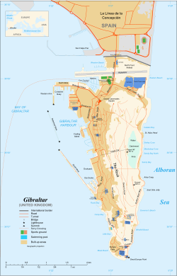
The North Mole at Gibraltar Harbour (pictured), in the British Overseas Territory of Gibraltar, [1] at the southern end of the Iberian Peninsula, [2] is one of a trio of breakwaters (shown on map) that provides protection to the harbour, in addition to that which results from the presence of the Rock of Gibraltar on its east side. [3] The North Mole is positioned at the northern and western aspects of the northern section of the harbour, [3] [4] which is located just north of the east entrance to the Strait of Gibraltar. [5] [6] The L-shaped breakwater includes a Western Arm which runs south toward the Detached Mole, [4] [7] and measures 500 metres (1,600 ft) in length. The northern section of the harbour features the commercial port, which has a total length of almost 2,300 metres (7,500 ft) of quay on the North Mole (including its Western Arm) for cruise ships, cargo handling, and bunkering. [3] Fifteen berths are available, [8] including six on the Western Arm and two on an extension jetty. [3]

The south end of the Western Arm of the North Mole, its "D" Head, is the site of the Gibraltar North Mole Lighthouse (location shown on map). The black, octagonal, latticework tower is constructed of cast-iron. Its light characteristic is a quick, flashing red light, and it has a range of five nautical miles. [7] [9] [10] The Elbow of the North Mole, its "E" Head, is the site of the Gibraltar North Mole Elbow Lighthouse. The gray, square, skeletal tower includes a round harbour control room. [7] The light characteristic is a fixed red light, with a range of five nautical miles. [7] [9] [10] Both lighthouses are operated by the Gibraltar Port Authority. [7]

Early history

Bay of Gibraltar c. 1750 includes Gibraltar Harbour with Old Mole and short New Mole. Gibraltar and Bay map 1750.jpg
Bay of Gibraltar c. 1750 includes Gibraltar Harbour with Old Mole and short New Mole.

The North Mole was formerly known as the Commercial Mole. It was a late nineteenth and early twentieth century [4] extension of the Old Mole (shown on map), which was begun in 1618, [11] and its extension, Devil's Tongue Battery, which was constructed between 1779 and 1783. [4] By 1895, the government had drawn up plans to modernize Gibraltar Harbour. They included construction of a dry dock at the New Mole Parade, which had been built in 1620. The 1895 plan also included enclosing Gibraltar Harbour by extending the New Mole (shown on map) and constructing a Detached Mole. At that time, the method of enclosing the northern end of the harbour had not yet been decided and was a matter of some controversy. [12]

The extensive changes to Gibraltar Harbour were largely financed through Britain's Naval Works Loan Act of 1895 and following years. The plan that met with final approval of the Admiralty included construction of a dockyard and a modern defensive harbour, safe from torpedo attack. The Commercial Mole was an integral component of that defensive harbour as it formed its northern boundary, and was also planned to serve the commercial needs of Gibraltar. Some of the cost of that breakwater was shouldered by the colony of Gibraltar. The Commercial Mole was constructed of rubble stone and extended west from the area of the Waterport Wharf, Old Mole, and Devil's Tongue. The breakwater included five jetties which extended north and south; it ended in the Western Arm which paralleled the jetties. The jetties and Western Arm were lined with a concrete wharf wall. By 1902, much of the construction of the new Gibraltar Harbour had been completed, although portions were still under construction, including the extension of the New Mole. While the Commercial Mole was intended to facilitate Gibraltar commerce, [13] by 1911 it was primarily utilised by the navy as a quay for destroyers. [4]

Recent history

Oil Sullage Tank continues burning through the night Oil Sullage Tank continues burning through the night.jpg
Oil Sullage Tank continues burning through the night

On the afternoon of 31 May 2011, the North Mole at Gibraltar Harbour was the site of an explosion involving an oil storage tank. Two workers had been welding on top of the tank. In addition to injuries sustained by the workers, one of whom was extensively burned, there were also injuries suffered by twelve passengers on the cruise ship MS Independence of the Seas , which had been berthed at the North Mole. An adjacent tank caught fire that evening, which required evacuation of the land-based fire fighters, limiting access to the fire from the sea. [14] Following the fire, concern was expressed about the availability of adequate supplies of fire-fighting foam prior to the blaze at the North Mole. [15] [16]

On 8 June 2012, a bunkering accident off the North Mole resulted in an oil spill, with the release of three tons of fuel into the sea. The refueling operation had involved the ship Frio Dolphin and the bunker tanker Vemaoil XX. The Gibraltar Oil Spill Contingency Plan was activated and, by the following day, most of the spilled oil had been contained. [17]

Related Research Articles

Portland Harbour

Portland Harbour is located beside the Isle of Portland, Dorset, on the south coast of England. Construction of the harbour began in 1849; when completed in 1872, its 520-hectare (1,300-acre) surface area made it the largest man-made harbour in the world, and remains one of the largest in the world today. It is naturally protected by Portland to the south, Chesil Beach to the west and mainland Dorset to the north. It consists of four breakwaters — two southern and two northern. These have a total length of 4.57 km and enclose approximately 1,000 hectares of water.

Saint Peter Port Harbour Port Harbour located in Guernsey

Saint Peter Port Harbour is located in Saint Peter Port, Guernsey. It was a natural anchorage used by the Romans which has been changed into an artificial harbour that is now the island's main port for passengers. Loose cargo, liquids and gas are shipped to and from St Sampson's harbour.

Bay of Gibraltar Bay at the southern tip of the Iberian Peninsula, shared by Spain and Gibraltar

The Bay of Gibraltar is a bay at the southern end of the Iberian Peninsula. It is around 10 km (6.2 mi) long by 8 km (5.0 mi) wide, covering an area of some 75 km2 (29 sq mi), with a depth of up to 400 m (1,300 ft) in the centre of the bay. It opens to the south into the Strait of Gibraltar and the Mediterranean Sea.

Mole (architecture)

A mole is a massive structure, usually of stone, used as a pier, breakwater, or a causeway separating two bodies of water. The word comes from Middle French mole, ultimately from Latin mōlēs, meaning a large mass, especially of rock; it has the same root as molecule and mole, the chemical unit of measurement. A mole may have a wooden structure built on top of it that resembles a wooden pier. The defining feature of a mole, however, is that water cannot freely flow underneath it, unlike a true pier. The oldest known mole is at Wadi al-Jarf, an ancient Egyptian harbor complex on the Red Sea.

Fremantle Harbour Port in Fremantle, Perth, Western Australia

Fremantle Harbour is Western Australia's largest and busiest general cargo port and an important historical site. The inner harbour handles a large volume of sea containers, vehicle imports and livestock exports, cruise shipping and naval visits, and operates 24 hours a day. It is located adjacent to the city of Fremantle, in the Perth metropolitan region.

Douglas Harbour Port

Douglas Harbour is located near Douglas Head at the southern end of Douglas, the capital of the Isle of Man. It is the island's main commercial shipping port. The Port of Douglas was the first in the world to be equipped with Radar.

Gibraltar North Mole Lighthouse

The Gibraltar North Mole Lighthouse is one of several lighthouses in Gibraltar, the British Overseas Territory at the southern end of the Iberian Peninsula. Also referred to as the Gibraltar "D" Head Lighthouse, its cast-iron tower is painted black. The active lighthouse west of the Rock of Gibraltar is positioned on the Western Arm of the North Mole at Gibraltar Harbour, and is operated by the Gibraltar Port Authority.

Gibraltar South Mole Lighthouse

The Gibraltar South Mole Lighthouse is one of several lighthouses in Gibraltar, a British Overseas Territory at the south end of the Iberian Peninsula. Also known as the Gibraltar "A" Head Lighthouse, it has a cast-iron, skeletal tower which is painted black and features two galleries. The lighthouse remains operational and is positioned west of the Rock of Gibraltar, on the South Mole at Gibraltar Harbour. It is operated by the Gibraltar Port Authority.

The Gibraltar North Mole Elbow Lighthouse is one of several lighthouses in Gibraltar, a British Overseas Territory at the south end of the peninsula of Iberia. Also known as the Gibraltar "E" Head Lighthouse, its tower is painted grey. The active lighthouse is west of the Rock of Gibraltar and positioned at the elbow of the North Mole at Gibraltar Harbour. The lighthouse is operated by the Gibraltar Port Authority.

South Mole, Gibraltar Harbour

The South Mole is a breakwater located in the southern section of Gibraltar Harbour, in the British Overseas Territory of Gibraltar, at the southern end of the Iberian Peninsula. Previously known as the New Mole and New Mole Extension, the South Mole, with the rest of harbour, is just north of the east entrance to the Strait of Gibraltar.

Detached Mole, Gibraltar Harbour

The Detached Mole is a breakwater located at the western aspect of the middle section of Gibraltar Harbour, in the British Overseas Territory of Gibraltar, at the southern end of the Iberian Peninsula. The Detached Mole, with the rest of harbour, is just north of the east entrance to the Strait of Gibraltar and was the site of the Detached Mole Battery. In addition to the role the breakwater plays in the defence of and access to the harbour, the Detached Mole provides berths for ships. The area adjacent to the mole is also a source of recreational and research opportunities, with dive sites at the wrecks of sunken ships.

Gibraltar Detached Mole ("B" Head) Lighthouse

The Gibraltar Detached Mole Lighthouse is one of several lighthouses in Gibraltar, a British Overseas Territory at the south end of the Iberian Peninsula. The lighthouse is positioned west of the Rock of Gibraltar, on the Detached Mole at the south entrance to Gibraltar Harbour.

The Gibraltar Detached Mole Lighthouse is one of several lighthouses in Gibraltar, a British Overseas Territory at the south end of the Iberian Peninsula. The lighthouse is positioned west of the Rock of Gibraltar, on the Detached Mole at the north entrance to Gibraltar Harbour.

Gibraltar Port Authority Agency in Gibraltar Port

The Gibraltar Port Authority develops and manages the Port of Gibraltar.

Gibraltar Cruise Terminal

The Gibraltar Cruise Terminal is located at the northern end of the Western Arm of the North Mole at Gibraltar Harbour. Construction of the facility in the British Overseas Territory of Gibraltar was completed in 1997. In the fifteen years since its opening, the terminal handled approximately three million cruise passengers. In May 2011, the explosion of a sullage tank on the Western Arm, while a cruise ship was berthed nearby, ultimately resulted in the loss of life of a dock worker. In October 2011, the Government of Gibraltar announced plans for expansion and renovation of the cruise terminal.

Port Kembla harbour

Port Kembla is a man-made cargo port or artificial harbour, with an outer harbour protected by breakwaters and an inner harbour constructed by dredging, located in the Illawarra region of New South Wales, Australia.

Rous Head

Rous Head is a reclaimed seabed area, which is utilised as a service industrial area. It includes a small harbour area that is located on the north side of the North Mole at Fremantle Harbour.

The Coastal coal-carrying trade of New South Wales involved the shipping of coal—mainly for local consumption but also for export or coal bunkering—by sea to Sydney from the northern and southern coal fields of New South Wales. It took place in the 19th and 20th centuries. It should not be confused with the export coal trade, which still exists today. There was also an interstate trade, carrying coal and coke to other Australian states that did not have local sources of black coal.

Wollongong Harbour Precinct

Wollongong Harbour Precinct is a heritage-listed shipping harbour at Cliff Road and Endeavour Drive, Wollongong, City of Wollongong, New South Wales, Australia. It was built from 1837. The historic precinct includes Belmore Basin, Government Dam, Government Basin, Stockade Point, Flagstaff Hill, Signal Hill, Brighton Beach, Boat Harbour and Fortress Hill. It was added to the New South Wales State Heritage Register on 5 May 2010.

References

  1. "List of Crown Dependencies & Overseas Territories". fco.gov.uk. British Foreign & Commonwealth Office. Archived from the original on 3 October 2012. Retrieved 6 August 2012.
  2. "Huge Underwater Mountain Discovered in Red Sea". workingharbor.wordpress.com. Working Harbor Committee. Archived from the original on 17 December 2012. Retrieved 6 August 2012.
  3. 1 2 3 4 "An Outline of the Port Infrastructure". Port of Gibraltar Handbook 2010-11. Land & Marine Publications Ltd, on behalf of the Gibraltar Port Authority. 2010. p. 13. Retrieved 6 August 2012.
  4. 1 2 3 4 5 Chisholm, Hugh, ed. (1911). "Gibraltar"  . Encyclopædia Britannica . 11 (11th ed.). Cambridge University Press. p. 940.
  5. "Military - Gibraltar". globalsecurity.org. GlobalSecurity.org. Retrieved 6 August 2012.
  6. "Gibraltar North Mole Elbow Light". lighthousedigest.com. Lighthouse Explorer, from Lighthouse Digest Magazine. Retrieved 6 August 2012.
  7. 1 2 3 4 5 Rowlett, Russ. "Lighthouses of Gibraltar". The Lighthouse Directory. University of North Carolina at Chapel Hill . Retrieved 9 August 2012.
  8. "General Description of the Port". Port of Gibraltar Handbook 2010-11. Land & Marine Publications Ltd, on behalf of the Gibraltar Port Authority. 2010. p. 63. Retrieved 6 August 2012.
  9. 1 2 "Port of Gibraltar - Port Map". gibraltarport.com. Gibraltar Port Authority. 2011. Retrieved 6 August 2012.[ dead link ]
  10. 1 2 "Publication 113 - List of Lights, Radio Aids, and Fog Signals" (PDF). msi.nga.mil. United States National Geospatial-Intelligence Agency. 2011. p. XI-XIII, 71. Archived from the original (PDF) on 19 June 2012. Retrieved 6 August 2012.
  11. United States Hydrographic Office (1916). Mediterranean pilot, Volume 1. U.S. G.P.O. p. 111. Retrieved 6 August 2012.
  12. John Adye, Major R.A. and Brevet Lt.-Colonel (1895). "The Past and the Future of Gibraltar". The Twentieth century, Volume 38. The Nineteenth Century and After Limited. pp. 822–825. Retrieved 6 August 2012.
  13. "Adapting Naval Ports to the Present Needs of the Fleet - Gibraltar". The new volumes of the Encyclopædia Britannica. A. & C. Black. 1902. p. 493. Retrieved 7 August 2012.
  14. "Major Fuel Tank Explosion at North Mole: Injuries". Gibraltar Chronicle. 31 May 2011. Archived from the original on 26 April 2012. Retrieved 6 August 2012.
  15. "Fire Brigade Not Adequately Resourced". Vox - The Truly Independent Gibraltar Newspaper. 9 June 2011. Retrieved 9 August 2012.
  16. "Linares Questions Govt on Fire Brigade Resources". Vox - The Truly Independent Gibraltar Newspaper. 17 June 2011. Retrieved 6 August 2012.
  17. "Maritime Chiefs Probe Weekend Oils Spill". Gibraltar Chronicle. 12 June 2012.