The Royal Gibraltar Regiment is part of British Forces Gibraltar for the British overseas territory of Gibraltar, which historically, along with Bermuda, Halifax, Nova Scotia, and Malta, had been designated an Imperial fortress rather than a colony. It was formed in 1958 from the Gibraltar Defence Force as an infantry unit, with an integrated artillery troop. The regiment is included in the British Army as a defence engagement force.

The Bombardment of Algiers was an attempt on 27 August 1816 by Britain and the Netherlands to end the slavery practices of Omar Agha, the Dey of Algiers. An Anglo-Dutch fleet under the command of Admiral Edward Pellew, 1st Viscount Exmouth bombarded ships and the harbour defences of Algiers.

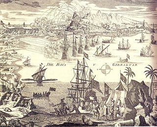
The Great Siege of Gibraltar was an unsuccessful attempt by Spain and France to capture Gibraltar from the British during the American Revolutionary War. It was the largest battle in the war by number of combatants.

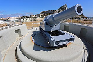
The 100-ton gun was a british coastal defense gun and is the world's largest black powder cannon. It was a 17.72-inch (450 mm) rifled muzzle-loading (RML) gun made by Elswick Ordnance Company, the armaments division of the British manufacturing company Armstrong Whitworth, owned by William Armstrong. The 15 guns Armstrong made were used to arm two Italian battleships and, to counter these, British fortifications at Malta and Gibraltar.

The siege of Gibraltar of 1727 saw Spanish forces besiege the British garrison of Gibraltar as part of the Anglo-Spanish War. Depending on the sources, Spanish troops numbered between 12,000 and 25,000. British defenders were 1,500 at the beginning of the siege, increasing up to about 5,000. After a five-month siege with several unsuccessful and costly assaults, Spanish troops gave up and withdrew. Following the failure the war drew to a close, opening the way for the 1728 Treaty of El Pardo and the Treaty of Seville signed in 1729.

The history of Gibraltar, a small peninsula on the southern Iberian coast near the entrance of the Mediterranean Sea, spans over 2,900 years. The peninsula has evolved from a place of reverence in ancient times into "one of the most densely fortified and fought-over places in Europe", as one historian has put it. Gibraltar's location has given it an outsized significance in the history of Europe and its fortified town, established in the Middle Ages, has hosted garrisons that sustained numerous sieges and battles over the centuries.

Rosia Bay is the only natural harbour in Gibraltar, the British Overseas Territory at the southern end of the Iberian Peninsula. Formerly referred to as Rosia Harbour, it is located on the southwest side of Gibraltar. Rosia Bay was the site of the Royal Navy Victualling Yard complex which was constructed in the early 19th century, allowing vessels to anchor and obtain provisions, including food and water. Vice Admiral Horatio Nelson obtained supplies for his Mediterranean Fleet at Rosia Bay. It was to that same anchorage that his vessel HMS Victory was towed after Nelson's death in the 1805 Battle of Trafalgar. The area is also the location of gun batteries, including Parson's Lodge Battery at the south end of the bay and Napier of Magdala Battery at the north end. In the 21st century, Rosia Bay was the focus of controversy following the government's demolition of the historic Rosia Water Tanks and construction of the affordable housing development Nelson's View, which necessitated the relocation of the owners of the adjacent 19th century Rosia Cottages.

Grand Casemates Gates, formerly Waterport Gate, provide an entrance from the northwest to the old, fortified portion of the city of the British Overseas Territory of Gibraltar, at Grand Casemates Square.

Princess Anne's Battery is an artillery battery in the British Overseas Territory of Gibraltar. It is located on Willis's Plateau at the northern end of the Upper Rock Nature Reserve, below Princess Caroline's Battery. It was named after Anne, Princess Royal and Princess of Orange, the eldest daughter of George II. However, its name is often confused with those of other batteries in the area. In 1732, guns were first mounted on the battery, which also saw action during the Great Siege of Gibraltar. Princess Anne's Battery was updated in the nineteenth and twentieth centuries, with the latter modernisation entailing the installation of four QF 5.25 inch guns with both anti-aircraft and coastal defence capabilities. The battery was manned into the early 1980s, after which it was decommissioned. The guns were refurbished in the early twenty-first century, and represent the world's only intact battery of 5.25 inch anti-aircraft guns. Princess Anne's and Amelia’s Battery are listed with the Gibraltar Heritage Trust.

The North Bastion, formerly the Baluarte San Pablo was part of the fortifications of Gibraltar, in the north of the peninsula, protecting the town against attack from the mainland of Spain. The bastion was based on the older Giralda tower, built in 1309. The bastion, with a mole that extended into the Bay of Gibraltar to the west and a curtain wall stretching to the Rock of Gibraltar on its east, was a key element in the defenses of the peninsula. After the British took Gibraltar in 1704 they further strengthened these fortifications, flooding the land in front and turning the curtain wall into the Grand Battery.

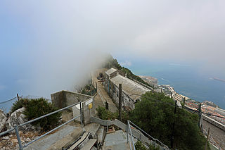
Levant Battery is an artillery battery in the British Overseas Territory of Gibraltar. It is located on Windmill Hill, at the southern end of the Upper Rock Nature Reserve, below observation post Fire Control South. It was named after the Levanter cloud, below which it perched, giving it an unobstructed view. Construction started in 1901 and, by 1903, a 9.2-inch Mark X breech-loading gun had been mounted. The battery was decommissioned in the 1970s and the gun was later removed, to rest in a scrap yard. A community group has been formed to garner support for the gun's recovery and restoration.

Rooke Battery is a now derelict artillery battery on the west side of the British Overseas Territory of Gibraltar.

Spy Glass Battery or Spyglass Battery was originally a high angle artillery battery in the British Overseas Territory of Gibraltar. The battery is mounted high on the rock to give extra range and protection. The battery was still in use during the Second World War as a listening post and site for a Bofors Gun.

Edward VII Battery was an artillery battery in the British Overseas Territory of Gibraltar.

Harding's Battery is a restored artillery battery in the British Overseas Territory of Gibraltar. It is located at Europa Point and includes the Europa Sunken Magazine that is now used as a visitor centre.

The Gibraltar peninsula, located at the far southern end of Iberia, has great strategic importance as a result of its position by the Strait of Gibraltar where the Mediterranean Sea meets the Atlantic Ocean. It has repeatedly been contested between European and North African powers and has endured fourteen sieges since it was first settled in the 11th century. The peninsula's occupants – Moors, Spanish, and British – have built successive layers of fortifications and defences including walls, bastions, casemates, gun batteries, magazines, tunnels and galleries. At their peak in 1865, the fortifications housed around 681 guns mounted in 110 batteries and positions, guarding all land and sea approaches to Gibraltar. The fortifications continued to be in military use until as late as the 1970s and by the time tunnelling ceased in the late 1960s, over 34 miles (55 km) of galleries had been dug in an area of only 2.6 square miles (6.7 km2).

The Lines of Contravallation of Gibraltar, known in English as the "Spanish Lines", were a set of fortifications built by the Spanish across the northern part of the isthmus linking Spain with Gibraltar. They later gave their name to the Spanish town of La Línea de la Concepción. The Lines were constructed after 1730 to establish a defensive barrier across the peninsula, with the aim of preventing any British incursions, and to serve as a base for fresh Spanish attempts to retake Gibraltar. They played an important role in the Great Siege of Gibraltar between 1779 and 1783 when they supported the unsuccessful French and Spanish assault on the British-held fortress. The siege was ended after the lines of contravallation were attacked by British and Dutch forces under the command of the Governor of Gibraltar, General Augustus Eliot. The attack caused the Spanish forces to retreat and abandon the fortifications and the combined British led forces virtually destroyed all the Spanish gun batteries and the enemy cannon and munitions either captured or destroyed. This attack is still commemorated to this day and is known as 'Sortie Day'.

The Koehler Depressing Carriage was a novel type of gun carriage invented in 1782 by Lt George Frederick Koehler of the Royal Artillery. It was devised to enable cannon to be fired at a steeply downward-facing angle and was made necessary by the peculiar circumstances that the British Army faced during the Great Siege of Gibraltar between 1779 and 1783. The carriage saw active service during the siege, when it was used to support the British counter-bombardment of Spanish and French artillery batteries during the successful defence of Gibraltar. Its success made Koehler famous and has been commemorated in a number of different forms over the last 230 years.

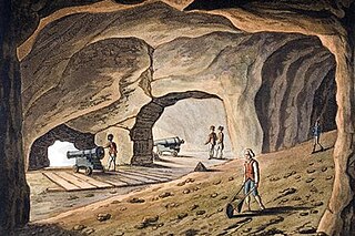
Henry Ince (1736–1808) was a sergeant-major in the British Army who achieved fame as the author of a plan to tunnel through the North Face of the Rock of Gibraltar in 1782, during the Great Siege of Gibraltar. As a result of his work, by the end of the 18th century Gibraltar had almost 4,000 feet (1,200 m) of tunnels in which dozens of cannons were mounted overlooking the isthmus linking the peninsula to Spain. He was one of the first members of the Soldier Artificer Company, a predecessor to today's Royal Engineers, and rose to be the company's senior non-commissioned officer. He was also a founder of Methodism in Gibraltar through his activities as a Methodist lay preacher. Ince spent most of his life in the Army and served for 36 years in Gibraltar before retiring to Devon four years before he died at the age of 72.

Windmill Hill or Windmill Hill Flats is one of a pair of plateaux, known collectively as the Southern Plateaux, at the southern end of the British Overseas Territory of Gibraltar. It is located just to the south of the Rock of Gibraltar, which descends steeply to the plateau. Windmill Hill slopes down gently to the south with a height varying from 120 metres (390 ft) at the north end to 90 metres (300 ft) at the south end. It covers an area of about 19 hectares, though about 6 hectares at the north end is built over. The plateau is ringed to the south and east with a line of cliffs which descend to the second of the Southern Plateaux, Europa Flats, which is itself ringed by sea cliffs. Both plateaux are the product of marine erosion during the Quaternary period and subsequent tectonic uplift. Windmill Hill was originally on the shoreline and its cliffs were cut by the action of waves, before the ground was uplifted and the shoreline moved further out to the edge of what is now Europa Flats.


