
Stack Rock Fort is a fort built on a small island in the Milford Haven Waterway, Pembrokeshire, Wales. A 3-gun fort was built between 1850 and 1852, and then upgraded from 1859 to 1871 with a new building that completely encased the original gun tower. It is now a Grade II* listed building and a scheduled monument.

Cliffe Fort is a disused artillery fort built in the 1860s to guard the entrance to the River Thames from seaborne attack. Constructed during a period of tension with France, it stands on the south bank of the river at the entrance to Cliffe Creek in the Cliffe marshes on the Hoo Peninsula in North Kent, England. Its location on marshy ground caused problems from the start and necessitated changes to its design after the structure begin to crack and subside during construction. The fort was equipped with a variety of large-calibre artillery guns which were intended to support two other nearby Thamesside forts. A launcher for the Brennan torpedo—which has been described as the world's first practical guided missile—was installed there at the end of the 19th century but was only in active use for a few years.

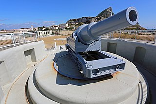
Parson's Lodge Battery is a coastal battery and fort in the British Overseas Territory of Gibraltar.

The Southport Gates are three city gates in the British Overseas Territory of Gibraltar. They are located in the Charles V Wall, one of the 16th century fortifications of Gibraltar. The gates are clustered together, with the South Bastion to the west, and the Trafalgar Cemetery to the east. The first and second Southport Gates were constructed at present day Trafalgar Road in 1552 and 1883, respectively. The third gate, Referendum Gate, is the widest of the three and was constructed in 1967 at Main Street, immediately west of the first two gates. The Southport Gates are listed with the Gibraltar Heritage Trust.

The North Bastion, formerly the Baluarte San Pablo was part of the fortifications of Gibraltar, in the north of the peninsula, protecting the town against attack from the mainland of Spain. The bastion was based on the older Giralda tower, built in 1309. The bastion, with a mole that extended into the Bay of Gibraltar to the west and a curtain wall stretching to the Rock of Gibraltar on its east, was a key element in the defenses of the peninsula. After the British took Gibraltar in 1704 they further strengthened these fortifications, flooding the land in front and turning the curtain wall into the Grand Battery.

Lascaris Battery, also known as Fort Lascaris or Lascaris Bastion, is an artillery battery located on the east side of Valletta, Malta. The battery was built by the British in 1854, and it is connected to the earlier St. Peter & Paul Bastion of the Valletta Land Front. In World War II, the Lascaris War Rooms were dug close to the battery, and they served as Britain's secret headquarters for the defence of the island.

The Orange Bastion is one of the many bastions in the British Overseas Territory of Gibraltar, which served to protect it against its many sieges. It is located along the Line Wall Curtain and was built to protect Gibraltar Harbour against enemy attack.

King's Bastion is a coastal bastion on the western front of the fortifications of the British overseas territory of Gibraltar, protruding from the Line Wall Curtain. It is located between Line Wall Road and Queensway and overlooks the Bay of Gibraltar. It played a crucial role in defending The Rock during the Great Siege of Gibraltar. In more recent history the bastion was converted into a generating station which powered Gibraltar's electricity needs. Today it continues to serve the community as Gibraltar's leisure centre.

Wellington Front is a fortification in the British Overseas Territory of Gibraltar. It was built in 1840 on a site established by the Spanish in 1618.

Buena Vista Battery was an artillery battery near the Buena Vista Barracks at the southern end of the British Overseas Territory of Gibraltar. It is located on a slight ridge in front of the nearby Buena Vista Barracks, which was once the base of the Royal Gibraltar Regiment.

Zoca Flank Battery is an artillery battery on the west side of the British Overseas Territory of Gibraltar.
Harding's Battery is a restored artillery battery in the British Overseas Territory of Gibraltar. It is located at Europa Point and includes the Europa Sunken Magazine that is now used as a visitor centre.

Alexandra Battery is a coastal artillery battery in the British Overseas Territory of Gibraltar. It was constructed at the neck of the South Mole to enfilade the coastal fortifications of Gibraltar. The battery stood on the site of several previous fortifications; it was built over the New Mole Battery, which was itself constructed on the site of an old Spanish fort in front of the Tuerto Tower.
Engineer Battery was an artillery battery in the British Overseas Territory of Gibraltar.

The Gibraltar peninsula, located at the far southern end of Iberia, has great strategic importance as a result of its position by the Strait of Gibraltar where the Mediterranean Sea meets the Atlantic Ocean. It has repeatedly been contested between European and North African powers and has endured fourteen sieges since it was first settled in the 11th century. The peninsula's occupants – Moors, Spanish, and British – have built successive layers of fortifications and defences including walls, bastions, casemates, gun batteries, magazines, tunnels and galleries. At their peak in 1865, the fortifications housed around 681 guns mounted in 110 batteries and positions, guarding all land and sea approaches to Gibraltar. The fortifications continued to be in military use until as late as the 1970s and by the time tunnelling ceased in the late 1960s, over 34 miles (55 km) of galleries had been dug in an area of only 2.6 square miles (6.7 km2).

Prince Albert's Front is a curtain wall that formerly comprised part of the seafront fortifications of Gibraltar. It runs between the King's Bastion and Orange Bastion. The Front was constructed in 1842 after a report by Major General Sir John Thomas Jones recommended improving Gibraltar's seafront defences to guard against the threat of an amphibious assault. It was named after Prince Albert, Queen Victoria's prince consort. The Front straightened out the line of Gibraltar's coastal curtain wall; parts of the original curtain wall, some of which dates from the Moorish period over 500 years ago, can still be seen.

The West Place of Arms is a place-of-arms in the British Overseas Territory of Gibraltar that was originally used as a troop assembly point. It is located in the gap between the North Bastion and its Counterguard, a structure built in 1804.

The counterguard is an outwork in a bastioned fortification system that usually comprises only a low rampart and which is sited in front of the actual fortress moat that runs around the bastions or ravelins. The rampart way of a counterguard is, however, so constructed and at least wide enough that it enables the positioning of guns. An additional ditch in front of it guards the work from a frontal enemy assault. The function of counterguards was to protect the higher ravelin or bastion behind it from direct fire and to delay an attack on it as long as possible. So that the counterguards and the works that they were to protect, could not come under simultaneous fire along the line of the rampart they were not allowed to run parallel to one another.
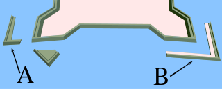
A couvreface in fortification architecture is a small outwork that was built in front of the actual fortress ditch before bastions or ravelins. It usually just consisted of a low rampart with a breastwork that protected its defending infantry. Another ditch in front of the work guarded it from immediate frontal assault. The function of couvrefaces was to protect the faces of the higher ravelin or bastion behind it from direct artillery fire. So that the couvreface and the works behind it could not come under simultaneous fire from an enemy battery along the line of the ramparts they were not allowed to run parallel to one another. Similar to the couvreface is the larger counterguard which, by contrast, was designed to enable the positioning of guns. Couvrefaces are found particularly in Dutch and French fortifications from the 17th to the early 19th centuries.

The fortifications of Valletta are a series of defensive walls and other fortifications which surround Valletta, the capital city of Malta. The first fortification to be built was Fort Saint Elmo in 1552, but the fortifications of the city proper began to be built in 1566 when it was founded by Grand Master Jean de Valette. Modifications were made throughout the following centuries, with the last major addition being Fort Lascaris which was completed in 1856. Most of the fortifications remain largely intact today.


