
The North Bastion, formerly the Baluarte San Pablo was part of the fortifications of Gibraltar, in the north of the peninsula, protecting the town against attack from the mainland of Spain. The bastion was based on the older Giralda tower, built in 1309. The bastion, with a mole that extended into the Bay of Gibraltar to the west and a curtain wall stretching to the Rock of Gibraltar on its east, was a key element in the defenses of the peninsula. After the British took Gibraltar in 1704 they further strengthened these fortifications, flooding the land in front and turning the curtain wall into the Grand Battery.

Couvreport Battery is an artillery battery in the British Overseas Territory of Gibraltar.

Devil's Tongue Battery was an artillery battery in the British Overseas Territory of Gibraltar. The battery could overlook the harbour but the remains are now surrounded by reclaimed land.
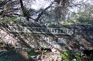
Forbes' Batteries are a pair of artillery batteries in the British Overseas Territory of Gibraltar. The batteries are casemated.

Gardiner's Battery is an artillery battery in the British Overseas Territory of Gibraltar. It is named after the governor Sir Robert Gardiner.
Jones' Battery is one of the best preserved of the "retired" artillery battery in the British Overseas Territory of Gibraltar. It was named after Sir John Thomas Jones who once controlled the fortifications here.
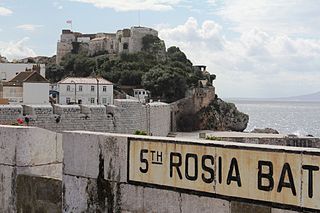
The Rosia Batteries are a group of artillery batteries in the British Overseas Territory of Gibraltar.

Europa Advance Batteries were a group of three artillery batteries in the British Overseas Territory of Gibraltar. They are located north east from Europa Point.

Alexandra Battery is a coastal artillery battery in the British Overseas Territory of Gibraltar. It was constructed at the neck of the South Mole to enfilade the coastal fortifications of Gibraltar. The battery stood on the site of several previous fortifications; it was built over the New Mole Battery, which was itself constructed on the site of an old Spanish fort in front of the Tuerto Tower.
Civil Hospital Battery was an artillery battery in the British Overseas Territory of Gibraltar.
Cumberland Flank Battery was an artillery battery in the British Overseas Territory of Gibraltar.
Devil's Bowling Green Battery was an artillery battery in the British Overseas Territory of Gibraltar. In 1859 the battery had two guns that looked over Little Bay. This battery was on the shoreline but it was overlooked by the Buena Vista Battery and the seven guns of the Europa Pass Battery
Engineer Battery was an artillery battery in the British Overseas Territory of Gibraltar.
Half Way Battery was an artillery battery in the British Overseas Territory of Gibraltar. The battery was on the coast on the eastern side of the isthmus just north of Europa Point Lighthouse. In 1859 there were two guns.
Lady Augusta's Battery was an artillery battery in the British Overseas Territory of Gibraltar.
New Mole Battery was an artillery battery in the British Overseas Territory of Gibraltar.
Prince of Wales Battery is an artillery battery in the British Overseas Territory of Gibraltar.
Woodford's Battery was an artillery battery in the British Overseas Territory of Gibraltar. It is located at Europa Flats between the Defensible Barracks and the Officer's Barracks and Eliott's Battery.

The fortifications of Gibraltar have made the Rock of Gibraltar and its environs "probably the most fought over and most densely fortified place in Europe, and probably, therefore, in the world", as Field Marshal Sir John Chapple has put it. The Gibraltar peninsula, located at the far southern end of Iberia, has great strategic importance as a result of its position by the Strait of Gibraltar where the Mediterranean Sea meets the Atlantic Ocean. It has repeatedly been contested between European and North African powers and has endured fourteen sieges since it was first settled in the 11th century. The peninsula's occupants – Moors, Spanish, and British – have built successive layers of fortifications and defences including walls, bastions, casemates, gun batteries, magazines, tunnels and galleries. At their peak in 1865, the fortifications housed around 681 guns mounted in 110 batteries and positions, guarding all land and sea approaches to Gibraltar. The fortifications continued to be in military use until as late as the 1970s and by the time tunnelling ceased in the late 1960s, over 34 miles (55 km) of galleries had been dug in an area of only 2.6 square miles (6.7 km2).

The King's Lines are a walled rock-cut trench on the lower slopes of the north-west face of the Rock of Gibraltar. Forming part of the Northern Defences of the fortifications of Gibraltar, they were originally created some time during the periods when Gibraltar was under the control of the Moors or Spanish. They are depicted in a 1627 map by Don Luis Bravo de Acuña, which shows their parapet following a tenaille trace. The lines seem to have been altered subsequently, as maps from the start of the 18th century show a more erratic course leading from the Landport, Gibraltar's main land entrance, to the Round Tower, a fortification at their western end. A 1704 map by Johannes Kip calls the Lines the "Communication Line of the Round Tower".

