
The Trafalgar Cemetery is a cemetery in the British Overseas Territory of Gibraltar. Formerly known as the Southport Ditch Cemetery, it occupies a small area of land just to the south of the city walls, in what had been a defensive ditch during the period of Spanish rule of Gibraltar. Although it is named for the Battle of Trafalgar of 21 October 1805, only two victims of the battle are buried there. The remainder of the interments are mostly of those killed in other sea battles or casualties of the yellow fever epidemics that swept Gibraltar between 1804 and 1814. In addition, tombstones were transferred to the Trafalgar Cemetery from St. Jago's Cemetery and Alameda Gardens.
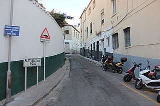
Flat Bastion Road is a road in Gibraltar, the British Overseas Territory at the southern end of the Iberian Peninsula. The road runs north–south, providing views of the city and Bay of Gibraltar. Previously known in Spanish as Senda del Moro, the traditional Llanito name for the road is Cuesta de Mr. Bourne.

Parson's Lodge Battery is a coastal battery and fort in the British Overseas Territory of Gibraltar.

Rosia Bay is the only natural harbour in Gibraltar, the British Overseas Territory at the southern end of the Iberian Peninsula. Formerly referred to as Rosia Harbour, it is located on the southwest side of Gibraltar. Rosia Bay was the site of the Royal Navy Victualling Yard complex which was constructed in the early 19th century, allowing vessels to anchor and obtain provisions, including food and water. Vice Admiral Horatio Nelson obtained supplies for his Mediterranean Fleet at Rosia Bay. It was to that same anchorage that his vessel HMS Victory was towed after Nelson's death in the 1805 Battle of Trafalgar. The area is also the location of gun batteries, including Parson's Lodge Battery at the south end of the bay and Napier of Magdala Battery at the north end. In the 21st century, Rosia Bay was the focus of controversy following the government's demolition of the historic Rosia Water Tanks and construction of the affordable housing development Nelson's View, which necessitated the relocation of the owners of the adjacent 19th century Rosia Cottages.
Jews' Gate Cemetery is a Jewish cemetery located on Windmill Hill within a nature reserve in the British Overseas Territory of Gibraltar. Also known as the Windmill Hill Cemetery, it is the site of the earliest known Jewish burials in Gibraltar. The cemetery opened by 1746 and closed in 1848. It is the burial site of a number of Gibraltar's Chief Rabbis. The graveyard is protected by the law of Gibraltar.
The Rosia Water Tanks were large water tanks built at the turn of the nineteenth century at Rosia Bay in the British Overseas Territory of Gibraltar. They were constructed based on the recommendation by Admiral John Jervis, 1st Earl of St Vincent that the Victualling Yard complex be relocated to Rosia Bay. The complex allowed Royal Navy vessels to obtain both food and water at one site. The Rosia Water Tanks remained in the possession of the Ministry of Defence until 2004, at which time they were transferred to the Government of Gibraltar. Despite local and international criticism, and a court case brought by the Gibraltar Heritage Trust, the tanks were demolished in 2006 to make way for affordable housing. When developer OEM International's funding proved insufficient to complete the project the government repossessed the site.

Flat Bastion is a bastion which projects southward from the Charles V Wall in the British Overseas Territory of Gibraltar. Once known as the St. Jago's Bastion or the Baluarte de Santiago in Spanish, the fortification was built by the Spanish in the mid 16th century and formed part of the southern defences of the city of Gibraltar, together with Charles V Wall, Southport Gates, Southport Ditch, and South Bastion. In 1859, six guns, four 12-pounders and two 12-pound carronades, were installed on the bastion, and four years later, five 32-pounders were mounted on the fortification.
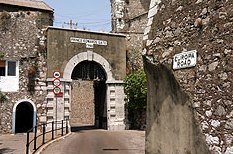
Prince Edward's Gate is a city gate at the entrance to Prince Edward's Road in the British Overseas Territory of Gibraltar. It cuts through Charles V Wall, one of the 16th century fortifications of Gibraltar at the former southern limit of the city. The gate is adjacent to the west wall of the Flat Bastion, another 16th-century fortification. The gate was named after Prince Edward, the future Duke of Kent, and was opened in 1790, the same year the prince arrived at Gibraltar as commander of the 7th Regiment of Foot. While the gate now has a limited role in the defence of Gibraltar, it continues to provide vehicular and pedestrian access through Charles V Wall. Prince Edward's Gate is listed with the Gibraltar Heritage Trust.
An orillon, also known as an orillion, is an architectural element of a military fortification. The ear-shaped projection of masonry provided defense for guns and soldiers at the flank of a bastion. However, an orillon could also shield a city gate.

The Southport Gates are three city gates in the British Overseas Territory of Gibraltar. They are located in the Charles V Wall, one of the 16th century fortifications of Gibraltar. The gates are clustered together, with the South Bastion to the west, and the Trafalgar Cemetery to the east. The first and second Southport Gates were constructed at present day Trafalgar Road in 1552 and 1883, respectively. The third gate, Referendum Gate, is the widest of the three and was constructed in 1967 at Main Street, immediately west of the first two gates. The Southport Gates are listed with the Gibraltar Heritage Trust.

Nun's Well is an ancient underground water reservoir in the British Overseas Territory of Gibraltar. It is located at Europa Point, and is thought to be of the Moorish period. It represents some of the earliest evidence of an artificial water supply in Gibraltar. The name of the cistern is thought to be derived from the nuns associated with the Shrine of Our Lady of Europe. In the eighteenth century, Nun's Well supplied the military with water. In the early nineteenth century, it provided water for the brewery that was built next door. In 1988, the Royal Engineers constructed what is now the main building, which has a castle-like appearance. Nun's Well became the focus of controversy during the 2010-2011 restoration of the site.

Streets in the British Overseas Territory of Gibraltar are represented by road signs as in the United Kingdom. As of 2007, Gibraltar has a network of 29 kilometres (18 mi) of roads.

Princess Caroline's Battery is an artillery battery in the British Overseas Territory of Gibraltar. It is located at the northern end of the Upper Rock Nature Reserve, at the junction of Willis's Road and Queen's Road. The nearby Princess Anne's Battery is often mistakenly referred to as Princess Caroline's Battery. The latter was built in 1732 and named after Princess Caroline, the daughter of King George II. Princess Caroline's Battery was updated in 1905, and a 6 inch Mark VII gun was mounted above the magazine. Later, the battery was decommissioned and the gun removed. The underground magazine is now home to the Military Heritage Centre, which includes the Memorial Chamber.

Princess Anne's Battery is an artillery battery in the British Overseas Territory of Gibraltar. It is located on Willis's Plateau at the northern end of the Upper Rock Nature Reserve, above Princess Caroline's Battery. It was named after Anne, Princess Royal and Princess of Orange, the eldest daughter of George II. However, its name is often confused with those of other batteries in the area. In 1732, guns were first mounted on the battery, which also saw action during the Great Siege of Gibraltar. Princess Anne's Battery was updated in the nineteenth and twentieth centuries, with the latter modernisation entailing the installation of four QF 5.25 inch guns with both anti-aircraft and coastal defence capabilities. The battery was manned into the early 1980s, after which it was decommissioned. The guns were refurbished in the early twenty-first century, and represent the world's only intact battery of 5.25 inch anti-aircraft guns. Princess Anne's Battery is listed with the Gibraltar Heritage Trust.

The South Bastion was part of the fortifications of Gibraltar, protecting the western base of the Charles V Wall. It was originally built by Spanish military engineers, later improved by the British. The South Bastion stands at the south end of the Line Wall Curtain which defends the town from attack from the Bay of Gibraltar. Another curtain wall runs east from the bastion to the base of a precipice. This wall is pierced by the Southport Gates, guarded by the South Bastion and the Flat Bastion on either side.
O'Hara's Battery is an artillery battery in the British Overseas Territory of Gibraltar. It is located at the highest point of the Rock of Gibraltar, near the southern end of the Upper Rock Nature Reserve, in close proximity to Lord Airey's Battery. It was constructed in 1890 at the former site of a watchtower that had earned the name O'Hara's Folly. The battery and tower were both named after the Governor of Gibraltar Charles O'Hara. The first gun mounted on the battery was a 6-inch breech loading gun, which was replaced with a 9.2 inch Mark X BL gun in 1901. The battery was in use during World War II and was last fired during training exercises in 1976. O'Hara's Battery has been refurbished and is open to the public. The battery and its associated works are listed with the Gibraltar Heritage Trust.

Princess Amelia's Battery is an artillery battery in the British Overseas Territory of Gibraltar. It is located on Willis's Plateau at the northern end of the Upper Rock Nature Reserve, adjacent to Gun No. 4 of Princess Anne's Battery. It was named after Princess Amelia of Great Britain, the second daughter of George II. It was formerly referred to as the 2nd Willis's Battery. The plateau and its batteries had previously been named after an artillery officer by the name of Willis who was outstanding during the capture of Gibraltar in 1704. Princess Amelia's Battery saw action during the Great Siege of Gibraltar, during which it sustained substantial damage. Little remains of the original site, aside from two derelict buildings. The battery is listed with the Gibraltar Heritage Trust.

Green's Lodge Battery is an artillery battery in the British Overseas Territory of Gibraltar. It is located on the North Face of the Rock of Gibraltar at the northern end of the Upper Rock Nature Reserve, above Farringdon's Battery. Also known as the Superior Battery, it was named after General Sir William Green, who served in Gibraltar for twenty-two years, most of them as the chief engineer of Gibraltar. In 1776, guns were first mounted on the battery, which also saw action during the Great Siege of Gibraltar. The emplacement also underwent reconstruction in the early and mid twentieth century. Green's Lodge Battery is listed with the Gibraltar Heritage Trust.

King's Bastion is a coastal bastion on the western front of the fortifications of the British overseas territory of Gibraltar, protruding from the Line Wall Curtain. It is located between Line Wall Road and Queensway and overlooks the Bay of Gibraltar. It played a crucial role in defending The Rock during the Great Siege of Gibraltar. In more recent history the bastion was converted into a generating station which powered Gibraltar's electricity needs. Today it continues to serve the community as Gibraltar's leisure centre.

Jumper's Bastion may refer to one of two adjacent bastions in the British Overseas Territory of Gibraltar. They were both created in 1785 on the sites of previous constructions and named for a British Captain who was one on the first on shore during the Capture of Gibraltar in 1704.


