This article needs additional citations for verification .(December 2009) |
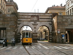
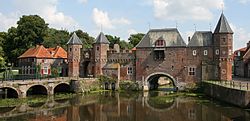
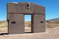
A city gate is a gate which is, or was, set within a city wall. It is a type of fortified gateway.
City gates were traditionally built to provide a point of controlled access to and departure from a walled city for people, vehicles, goods and animals. Depending on their historical context they filled functions relating to defense, security, health, trade, taxation, and representation, and were correspondingly staffed by military or municipal authorities. The city gate was also commonly used to display diverse kinds of public information such as announcements, tax and toll schedules, standards of local measures, and legal texts. It could be heavily fortified, ornamented with heraldic shields, sculpture or inscriptions, or used as a location for warning or intimidation, for example by displaying the heads of beheaded criminals or public enemies.
Notably in Denmark, many market towns used to have at least one city gate mostly as part of the city's fortifications, but during the Age of Absolutism their functions become closely linked to the collection of customs, the so-called octroi, which from 1660 onwards was charged to the market town's coffers. When absolutism in Denmark came to an end after the revolutions of 1848, gate consumption was abolished in 1852, and since then the city gates also began to disappear. [1]
Medieval Danish city gates are found today only in Vesterport, Faaborg, and Mølleporten, Stege, as well as in Flensburg, today in Germany. Further city gates, in one form or another, can be found across the world in cities dating back to ancient times to around the 19th century. Many cities would close their gates after a certain curfew each night, for example, a bigger one like Prague or a smaller one like the one in Flensburg, in the north of Germany.
With increased stability and freedom, many walled cities removed such fortifications as city gates, although many still survive; albeit for historic interest rather than security. Many surviving gates have been heavily restored, rebuilt or new ones created to add to the appearance of a city, such as Bab Bou Jalous in Fes. With increased levels of traffic, city gates have come under threat in the past for impeding the flow of traffic, such as Temple Bar Gate in London which was removed in the 19th century.
Pesaro is a comune (municipality) in the Italian region of Marche, capital of the province of Pesaro and Urbino, on the Adriatic Sea. According to the 2011 census, its population was 95,011, making it the second most populous city in the Marche, after Ancona. Pesaro was dubbed the "Cycling City" by the Italian environmentalist association Legambiente in recognition of its extensive network of bicycle paths and promotion of cycling. It is also known as "City of Music", for it is the birthplace of the composer Gioachino Rossini. In 2015 the Italian Government applied for Pesaro to be declared a "Creative City" in UNESCO's World Heritage Sites. In 2017 Pesaro received the European City of Sport award together with Aosta, Cagliari and Vicenza.
The Aurelian Walls are a line of city walls built between 271 AD and 275 AD in Rome, Italy, during the reign of the Roman Emperor Aurelian. They superseded the earlier Servian Wall built during the 4th century BC.
The Porta San Paolo is one of the southern gates in the 3rd-century Aurelian Walls of Rome, Italy. The Via Ostiense Museum is housed within the gatehouse. It is in the Ostiense quarter; just to the west is the Roman Pyramid of Cestius, an Egyptian-style pyramid, and beyond that is the Protestant Cemetery.
Arcos de la Frontera is a town and municipality in the Sierra de Cádiz comarca, province of Cádiz, in Andalusia, Spain. It is located on the northern, western and southern banks of the Guadalete river, which flows around three sides of the city under towering vertical cliffs, to Jerez and on to the Bay of Cádiz. The town commands a fine vista atop a sandstone ridge, from which the peak of San Cristóbal and the Guadalete Valley can be seen. The town gained its name by being the frontier of Spain's 13th-century battle with the Moors.
The Porta del Popolo, or Porta Flaminia, is a city gate of the Aurelian Walls of Rome that marks the border between Piazza del Popolo and Piazzale Flaminio.
The Via del Corso is a main street in the historical centre of Rome. It is straight in an area otherwise characterized by narrow meandering alleys and small piazzas. Considered a wide street in ancient times, the Corso is approximately 10 metres wide, and it only has room for two lanes of traffic and two narrow sidewalks. The northern portion of the street is a pedestrian area. The length of the street is roughly 1.5 kilometres.
Porta Tiburtina or Porta San Lorenzo is a gate in the Aurelian Walls of Rome, Italy, through which the Via Tiburtina exits the city.
Porta San Pancrazio is one of the southern gates of the Aurelian walls in Rome, Italy.
Porta Portese is an ancient city gate, located at the end of Via Portuense, where it meets Via Porta Portese, about a block from the banks of the Tiber in the southern edge of the Rione Trastevere of Rome, Italy.
Porta San Giovanni is a gate in the Aurelian Wall of Rome, Italy, named after the nearby Archbasilica of Saint John Lateran.
The Porta Asinaria is a gate in the Aurelian Walls of Rome. Dominated by two protruding tower blocks and associated guard rooms, it was built between 271 and 275 AD, at the same time as the Wall itself. It was not rebuilt or fortified in the time of Honorius and not restored by Theoderic as most of the other gates.
The Porta Nomentana was one of the gates in the Aurelian Walls of Rome, Italy. It is located along viale del Policlinico, around 70 m east of Porta Pia. It is now blocked and merely a boundary wall for the British Embassy.
Porta Sempione is a city gate of Milan, Italy. The name is used both to refer to the gate proper and to the surrounding district (quartiere), a part of the Zone 1 division, including the major avenue of Corso Sempione. The gate is marked by a landmark triumphal arch called Arco della Pace, dating back to the 19th century, although its origins can be traced back to a gate of the Roman walls of Milan.
The city Milan, Italy, has had three different systems of defending walls. The oldest, Roman walls were developed in two stages, the first in the Republican and the second in the Imperial era. The second wall system was realized in the Middle Ages, after the destruction of the city by Frederick I Barbarossa. Finally, the latest wall system was built by the Spanish rulers. While very little remains of these walls, their structure is clearly reflected in the urbanistic layout of the city. In particular, modern Milan has two roughly circular rings of streets, namely the "Cerchia dei Navigli" and the "Cerchia dei Bastioni", which essentially correspond to the Medieval and Spanish walls, respectively. Note that a third ring of roads just beyond the Inner Ring Road, called the External Ring Road, does not owe itself to any old city walls; but was part of the 1884 Beruto Plan for the city of Milan, created and named after a municipal engineer and public servant to the local city government.
The Arch of Augustus is a gate set in the former city wall of Rimini, Emilia-Romagna, in the form of an ancient Roman triumphal arch.
Porta Cavalleggeri was one of the gates of the Leonine Wall in Rome (Italy).
Porta Ardeatina was one of the gates of the Aurelian Walls in Rome (Italy).
San Niccolò al Carmine, also called Santa Maria del Carmine is a Renaissance style, Roman Catholic church and monastery located in Pian dei Mantellini #30, near the corner of Via della Diana in the Terzo de Citta of Siena, region of Tuscany, Italy. The church now serves as the Oratory for the Contrada of Pantera. Across the street from the belltower is the Palazzo Celsi Pollini. North along Pian dei Mantellini, toward the Arco delle Due Porte, and on the same side of the street are a number of palaces built around what was once the Monastery of the Derelict Women: in order they are the Neoclassical Palazzo Incontri, the Palazzo Ravissa and the Palazzo Segardi.
The Walls of Old San Juan is a defensive city wall that surrounds the western end of the San Juan Islet, site of the historic district of San Juan, Puerto Rico. This defensive wall system was built between the 16th and 18th centuries to protect the city and the Bay of San Juan, a highly strategic point in the Caribbean. These walls, along with the defensive fortresses in Old San Juan, form part of the UNESCO World Heritage Site-designated San Juan National Historic Site as they are characteristic examples of the historic methods of construction used in military architecture which adapted European designs and techniques to the special conditions of the Caribbean port cities.
Media related to City gates at Wikimedia Commons