The Walls of Lima were a fortification consisting mainly of walls and bastions whose purpose was to defend the city of Lima from exterior attacks. It was built between 1684 and 1687, during the ViceroyMelchor de Navarra y Rocafull (Duke of Palata)'s government.
The wall was located on the present streets of Alfonso Ugarte, Paseo Colón and Grau and the left bank of Rímac River. Under Luis Castaneda Lossio's management, he recovered a section of the remains of the left bank of the Rímac River, which are now visible as a part of the group known as "Parque de la Muralla," although these are probably from a previous construction known as "Tajamar de San Francisco." The Santa Lucía bastion is a sector of the wall located on the edge of Barrios Altos and El Agustino that still stands .[1]
History
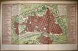
Map of the City of the Kings in 1744 which was public in the work of Jorge Juan and Antonio de Ulloa.
The old wall was built around the city to protect it from pirates attacks and other enemies of the Spanish crown in the 17th century. The wall had 10 exit and entry gates: Martinete, Maravillas, Barbones, Cocharcas, Santa Catalina, Guadalupe, Juan Simón, San Jacinto, Callao, Monserrate and the gate of la Guía in the Barrio de San Lázaro.[2]
As part of urban expansion programs and construction of new avenues, the wall was demolished in 1868 under José Balta's government. The wall never served the purpose for which it was built, to the point that Raúl Porras Barrenechea mentioned that "it died a virgin of gunpowder."
Current status
Part of the sea wall has been restored at the back of the Church of San Francisco, near the Government Palace, which has created a public space named Parque de la Muralla (Park of the Wall). In this park, the remnants of the foundations that had been the seawall are visible, which was done by the Franciscans in 1610. The aforementioned park has a restaurant and a shop selling hand-made items from different areas of the country. The park contains a statue of Francisco Pizarro, which used to be in the "Plaza Pizarro," located next to the Government Palace. There is also a museum exhibiting archaeological pieces found in the area.
Construction of an expressway on Grau Avenue uncovered some of the wall's remains.
In Barrios Altos, the remains of the walls near the Plazuela del Cercado is in good condition. The camal de Conchucos, which was the bastion of Santa Lucía, one of the surveillance points of the wall, is now a sports complex.
The wall was not a paragon of beauty. Except for the portals of Maravillas (1807) in the Barrios Altos and El Callao, the other gates, as told by the painter Juan Manuel Ugarte, "had no great artistic appeal. It is one of the most important tourist attractions, besides the houses, among others.[clarification needed]
Gallery
The walls of Lima in a plan of 1750
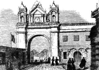
Aspect of the Gate of Callao, located in the Ovalo de la Reina, in 1870
Gate of Maravillas, which gave access to the fortified Lima
Lima is the capital and largest city of Peru. It is located in the valleys of the Chillón, Rímac and Lurín Rivers, in the desert zone of the central coastal part of the country, overlooking the Pacific Ocean. The city is considered the political, cultural, financial and commercial center of Peru. Due to its geostrategic importance, the Globalization and World Cities Research Network has categorized it as a "beta" tier city. Jurisdictionally, the metropolis extends mainly within the province of Lima and in a smaller portion, to the west, within the Constitutional Province of Callao, where the seaport and the Jorge Chávez Airport are located. Both provinces have regional autonomy since 2002.
Lima is a district of Lima Province in Peru. Lima district is the oldest in Lima Province and as such, vestiges of the city's colonial era remain today in the historic centre of Lima, which was declared a UNESCO World Heritage Site in 1988 and contains the foundational area known as Cercado de Lima.
The Rímac River is located in western Peru and is the most important source of potable water for the Lima and Callao Metropolitan Area. It belongs to the Pacific Slope, into which it flows after bathing the cities of Lima and Callao, together with the Chillón River, to the north, and the Lurín River, to the south. It is 204 km long and has a basin of 3,312 km², of which 2,237.2 km² is a humid basin. The basin has a total of 191 lagoons, of which only 89 have been studied. The river begins in the highlands of the Huarochirí Province in the Lima Region and its mouth is located in Callao, near Jorge Chávez International Airport.
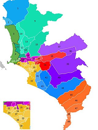
The Lima Metropolitan Area is an area formed by the conurbation of the Peruvian provinces of Lima and Callao. It is the largest of the metropolitan areas of Peru, the seventh largest in the Americas, the fourth largest in Latin America, and among the thirty largest in the world. The conurbation process started to be evident in the 1980s.
San Martín de Porres (SMP) is a district in Lima, Peru, located in the north area of the city. It is bordered by the Chillón River, marks its natural border with Ventanilla and Puente Piedra on the north; Callao on the west; Los Olivos, Comas on the northeast; Rímac and Independencia districts on the east; the Rímac River marks its natural border with Lima District and Carmen de la Legua Reynoso on the south. It is the second most populated district of Lima metropolitan area and Peru.
Located principally in the city centre or Cercado de Lima and Rímac areas, the Historic Centre of Lima is among the most important tourist destinations in Peru.
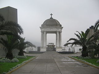
Presbyter Matías Maestro Cemetery, formerly the General Cemetery of Lima, is a cemetery, museum and historical monument located in the Barrios Altos neighbourhood of Lima District, in Lima, Peru. Inaugurated on May 31, 1808, it was the first pantheon in the city since burials were previously held in the city's churches. It was named in honour of its designer, Spanish priest Matías Maestro.
Barrios Altos is a Peruvian neighbourhood that forms the eastern part of Lima District, part of the historic centre of the city. It owes its name to the fact that, topographically, it is higher than the rest of the old part of the City, due to the elevation of the land that exists towards the Andes mountain range, which is evident in its streets to this day.
La Puerta del Conde was the main entrance to the fortified city of Santo Domingo, named to honor Governor Captain-General Bernardino de Meneses Bracamonte y Zapata, 1st Count of Peñalva, who during his tenure saved the city from a siege in 1655 by Englishmen General Robert Venables and Admiral William Penn amid the Third Anglo-Spanish War.
The Battle of Portada de Guías, also known as the Battle of Guía or Battle of Piñonate, was a battle between the Chilean Army and the secessionist Peruvian Republic in 1838, during the War of the Confederation.
The City Wall of San Juan is a city wall that surrounds the western end of the Islet of San Juan, site of the historic Old San Juan district in San Juan, Puerto Rico. This defensive wall system was built between the 16th and 20th centuries to protect the city and the Bay of San Juan, a highly strategic point in the Caribbean. These walls, along with the defensive fortresses in Old San Juan, form part of the UNESCO World Heritage Site-designated San Juan National Historic Site as they are characteristic examples of the historic methods of construction used in military architecture which adapted European designs and techniques to the special conditions of the Caribbean port cities.
The Park of the Wall is a public park located in the central district of Lima, Peru. It was inaugurated in 2004. Within its extension is part of the former Walls of Lima. The park is located between the Rímac River and the historic centre of Lima.
The Equestrian statue of Francisco Pizarro is a series of three bronze equestrian statues of Spanish Conquistador Francisco Pizarro by U.S. sculptor Charles Cary Rumsey. The statues are located in Buffalo, Trujillo and Lima. The latter two cities are Pizarro's places of birth and death, respectively.
Jirón Amazonas is a major street in the Damero de Pizarro, located in the historic centre of Lima, Peru. The street starts at its intersection with the Jirón Lampa and continues until it reaches Sebastián Lorente Avenue.
Jirón Junín is a major street in the Damero de Pizarro, located in the historic centre of Lima, Peru. The street starts at its intersection with the Jirón de la Unión and continues for 19 blocks until it reaches Nicolás Ayllón Avenue.
The Church of Saint Lazarus is a Catholic church in Rímac District, part of the Historic Centre of Lima, Peru. Built in 1586, it was the first church built in the area. Since then it has been rebuilt several times after the damage left by the various earthquakes in Peru. It is located on block five of Jirón Trujillo, at the intersection with Francisco Pizarro Avenue.
This page is based on this Wikipedia article Text is available under the CC BY-SA 4.0 license; additional terms may apply. Images, videos and audio are available under their respective licenses.

 The walls of Lima in a plan of 1750
 Aspect of the Gate of Callao, located in the Ovalo de la Reina, in 1870
 Gate of Maravillas, which gave access to the fortified Lima
 Muralla, Casco Antiguo de Lima