Barrios Altos

Last updated
Barrios Altos
Visitas a asentamientos humanos de San Juan de Miraflores (6882482604).jpg
Front view of the Legislative Palace as seen from the Plaza Bolívar
Country Peru
Department Lima
Province Lima
District Lima

Barrios Altos [lower-alpha 1] is a Peruvian neighbourhood that forms the eastern part of Lima District, part of the historic centre of the city. It owes its name to the fact that, topographically, it is higher than the rest of the old part of the City, due to the elevation of the land that exists towards the Andes mountain range, which is evident in its streets to this day.

Contents

Despite its historical significance, the neighbourhood, in comparison to the Cercado de Lima, is in poor shape, as many buildings' façades are not maintained and the collapse of buildings in the area results in the terrains becoming abandoned instead of rebuilt. [1] [2] As a result, a project targeting the area has been announced by PROLIMA, the entity in charge of the project under the auspices of the Ministry of Culture and the Municipality of Lima. [3]

History

Pre-Columbian era

St. Claire's Monastery (and mill). This mill ran on water from the Huatica River, which was, in reality, a pre-Hispanic irrigation canal. Molinosantaclara.jpg
St. Claire's Monastery (and mill). This mill ran on water from the Huatica River, which was, in reality, a pre-Hispanic irrigation canal.

The earliest mention of what is today Barrios Altos dates back to the first years of the Spanish presence in the Andes, through which the religious character that Barrios Altos had during the Inca hegemony in the Rímac Valley can be inferred. The documentation bequeathed to the present by the priests who directed the process of "Extirpation of Idolatries," tells us that an oracle was located in its vicinity, which due to its importance and prestige ended up giving its name to the valley and, over time, to the current capital city of Peru.

The oracle, which is believed to have links with that of Pachacámac located a few leagues to the south, identified in pre-Hispanic times the valley in which it was located, which was called Limay (in Quechua "place where people speak", referring to the speaking property of the oracle). Limay was the name that the Rímac valley had when the Spanish arrived, and which became Lima, a name that ended up being imposed on what was then the Ciudad de los Reyes.

Very little remains of this ancient pre-Hispanic religious centre. The oracle was destroyed by the extirpaters of idolatries. However, a huanca or stone nestled in the sidewalk that has a perforation as a characteristic remains to this day on the corner of Jirón Junín and Jirón Cangallo. Because of this it is called the Piedra Horadada and it is the only remains of the once prestigious oracle. [4]

Another evidence of the Andean Civilization in the current Barrios Altos is the so-called Huatica River. [5] This river, which is actually a canal, is a work of pre-Hispanic engineering in the Rímac valley that had the objective of expanding the agricultural barrier of the valley by transporting the river waters to distant fields. This expansive policy was applied in the valley since the Huari presence in the area (sixth century AD), a period from which the Huatica would date. Its course included the surroundings of the oracle, possibly being part of its water support. The Huatica was alive during the viceregal and republican era, when it was part of the urban landscape and above all an important irrigation canal, until the 20th century when it dried up due to urban expansion and the decrease in the flow of the Rímac River. Its structures are still found under the streets of the Barrios Altos.

Viceregal era

The Viceregal Fort of Santa Catalina, former Artillery and Military Police Barracks, in 1870. FuerteSantaCatalina1870.jpg
The Viceregal Fort of Santa Catalina, former Artillery and Military Police Barracks, in 1870.

When the Spanish founded the city in January 1535 in the Rímac valley, they did so less than a kilometre from the oracle that gave its name to the valley. Therefore, in a few years the expanding city included its surroundings. In the mid-16th century the oracle was destroyed, and a church was built in its place in dedication to Saint Anne. In the urban layout of the area, some pre-Hispanic vestiges were preserved, such as the Huatica River, which was an ancient irrigation canal. and which currently corresponds to Amazonas and Jauja streets. [6] Soon, the eastern sector of the city, built around the church, received the name Barrio de Santa Ana, the origin of today's Barrios Altos.

In 1571, Viceroy Francisco de Toledo decreed the creation of reduction towns throughout the Andean space, where the indigenous population should live to favor their control and evangelisation. Thus, to the east of the Santa Ana neighbourhood, the town of Santiago del Cercado was built, a reduction [lower-alpha 2] for the indigenous people of the City of the Kings. The reduction owed its name to the fact that it was dedicated to the apostle Santiago and was surrounded by a fence that had a single door for the entry and exit of its population. This gate was located in the current Cinco Esquinas of Barrios Altos.

With the construction of the Walls of Lima, part of Santiago del Cercado was destroyed and with it its perimeter wall, becoming integrated into the walled city next to the Santa Ana neighbourhood. From the union of both came what is currently known as Barrios Altos.

Historically, it could be said that the area, during the viceregal era, was occupied mainly by churches and the orchards and farms that belonged to the different religious orders, as can be seen on the maps of the time.

Republican era

Image of Saint Anne's Square around 1900. Santaana barriosaltos.jpg
Image of Saint Anne's Square around 1900.

Only in the middle of the 19th century, the area began to be populated in its large extent (although already at the end of the 18th century, 40% of the city's population lived in the Barrios Altos), with the central market emerging there, for example, on land that had belonged to the Convent of La Concepción. In the second half of the 19th century, a number of villas emerged, such as Quinta Heeren (built around 1880) and neighbourhoods such as: El Cercado (the oldest, whose origin dates back to around 1571), El Prado, Del Chirimoyo, Pampa de Lara, Cocharcas, Martinete, etc.

It can be said that the best time for the Barrios Altos was between the end of the 18th century and the first half of the 20th century, when this area did not have problems with crime, robberies and assaults, drug sellers and users, gangs and street sellers. The so-called Plaza de Viterbo (current block 3 of Jirón Amazonas) then stood out, located next to the Balta Bridge and in whose vicinity there was a cinema (Novedades, later called Cinelandia), the Railway station Lima-Lurín and the station of Line No. 7 of the Lima Tramway (a route that was closed in 1928). Currently, the Plaza de Viterbo only remains in the memory of some elderly residents, since the place was completely modified (currently there are sports slabs and the "Amazonas" fairground where used books are sold). The area surrounding the square was also characterized by the existence of viceregal buildings, converted into slums, that ran down from the ravines to the banks of the Rímac River. All of these slums, such as the old Hotel Amazonas which over the years became a slum known as the House of Dracula, were destroyed in the early 1970s with an unfinished plan to modernize the area.

Until the 1960s there were a good number of cinema-theatres, of which they survived until the first five years of the 1980s: the Conde de Lemos, located in the Plazuela de Buenos Aires, Delicias, located in front of the Maternidad de Lima , the Pizarro and Unión both located in Plaza Italia. Today none of these exist due to the decline that the area reached.

Decadence

The district, despite its importance, has become dilapidated over time. One such example is a three-storey building known as El Buque after its resemblance to a ship, built in the 19th century in a 1,131 plot and located in the corners of jirones Junín and Cangallo, declared part of the Cultural heritage of Peru. [3] Originally sporting marble staircases with bronze handrails and wooden balconies, it was built with the purpose of being the first housing complex after independence, being able to house 70 families in total. It has since been declared inhabitable, the result of a series of fires in 2012, 2014, 2016 and 2022 that neighbours blame on the drug addicts that sneak into the building through a hole made in a wall. [3]

Landmarks

Lord of Miracles festivities in 2020 Procesion del Senor del Santuario.jpg
Lord of Miracles festivities in 2020
San Marcos' Faculty of Medicine UNMSM Facultad de Medicina San Fernando.jpg
San Marcos' Faculty of Medicine
Matias Maestro Cemetery chapel CapillaPresbiteroMaestro.jpg
Matías Maestro Cemetery chapel

Barrios Altos is home to a number of landmarks from both the Spanish and Republican era, including:

See also

Notes

  1. Spanish for "Upper neighbourhoods."
  2. A population centre in which dispersed indigenous people were grouped, for the purposes of evangelisation and cultural assimilation. [7]

Related Research Articles

<span class="mw-page-title-main">Walls of Lima</span> 17th-century fortification in Lima

The Walls of Lima were a fortification consisting mainly of walls and bastions whose purpose was to defend the city of Lima from exterior attacks. It was built between 1684 and 1687, during the Viceroy Melchor de Navarra y Rocafull 's government.

<span class="mw-page-title-main">Lima District</span> District in Lima, Peru

Lima is a district of Lima Province in Peru. Lima district is the oldest in Lima Province and as such, vestiges of the city's colonial era remain today in the historic centre of Lima, which was declared a UNESCO World Heritage Site in 1988 and contains the foundational area known as Cercado de Lima.

<span class="mw-page-title-main">Rímac District</span> District in Lima, Peru

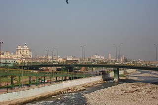
Rímac, known until the 19th century as the neighbourhood of San Lázaro, is a district in the Lima Province, Peru. It lies directly to the north of downtown Lima, to which it is connected by six bridges over the Rímac River. The district also borders the Independencia, San Martín de Porres, and San Juan de Lurigancho districts. Vestiges of Lima's colonial heyday remain today in an area of the Rímac district known as the Historic centre of Lima, which was declared a UNESCO World Heritage Site in 1988. Downtown Rímac District has, like its southern counterpart, its eastern and western sides divided by Jirón Trujillo, which connects to Lima District's Jirón de la Unión through the Puente de Piedra, the oldest bridge in the whole city. Rímac's East side features the Plaza de Acho, the most famous bullfighting arena in South America and one of the most well known in the world.

<span class="mw-page-title-main">Barrio Chino (Lima)</span>

Barrio chino is a neighborhood in Lima, Peru that is centered on two blocks – 7 and 8 – of Jirón Ucayali in downtown. The neighborhood was founded in the mid-19th century by Chinese immigrants, but it was heavily damaged in the late 19th century by the War of the Pacific and further declined in the following decades. It experienced a revival starting in the 1970s and is now a thriving resource for Chinese-Peruvian culture.

The Historic Centre of Trujillo is the main urban area and the most important center of development and unfolding in the Peruvian city of Trujillo located in La Libertad Region. The whole process of its original urban fabric is in elliptical shape surrounded by España Avenue that was built in the wake of the Wall of Trujillo. It houses the seat of city government and other important entities in the locality. In the center of this historic urban area is the Plaza de Armas of Trujillo that was the scene of the Spanish founded of the city in 1534 and the proclamation of the independence of Trujillo on December 29, 1820.

<span class="mw-page-title-main">Quinta de Presa</span> Quinta in Lima, Peru

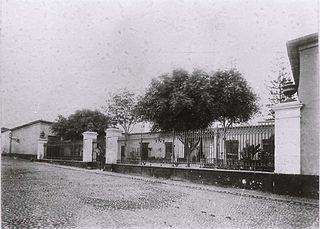
The Quinta de Presa is a French-style country mansion built in the 18th century during the government of the then viceroy of Peru, Manuel de Amat y Junyent. It comprises a constructed area of 15,159 square metres (163,170 sq ft). It is located in the jirón Chira of the Rímac district, Lima, Peru.

<span class="mw-page-title-main">Plaza Italia, Lima</span> Square in Lima, Peru

Italy Square, formerly known as Saint Anne's Square, is a public square in the Barrios Altos neighbourhood of Lima, Peru. It was the second square built by the Spanish during the colonial era and later served as one of the four squares where the independence of Peru was declared in the city.

Jirón Amazonas is a major street in the Damero de Pizarro, located in the historic centre of Lima, Peru. The street starts at its intersection with the Jirón Lampa and continues until it reaches Sebastián Lorente Avenue.

<span class="mw-page-title-main">Jirón Junín</span> Street in Lima, Peru

Jirón Junín is a major street in the Damero de Pizarro, located in the historic centre of Lima, Peru. The street starts at its intersection with the Jirón de la Unión and continues for 19 blocks until it reaches Nicolás Ayllón Avenue.

<span class="mw-page-title-main">Jirón Trujillo</span> Street in Lima, Peru

Jirón Trujillo is an important street in Rímac District, part of the historic centre of Lima, Peru. The street starts at the Puente de Piedra, where it is continued on the other side of the Rímac River by the Jirón de la Unión, and continues until it reaches the Alameda de los Bobos. It therefore joins the so-called monumental zones of both Rímac and Lima districts.

<span class="mw-page-title-main">Church of the Good Death</span> Church in Lima, Peru

The Church and Convent of the Good Death, also known as the Church of Saint Camillus, after the order's founder, is a Catholic church and convent in the colonial area of the neighbourhood of Barrios Altos in Lima, Peru. The current temple was built at the end of the 19th century and is dedicated to Our Lady of the Good Death. It is located at the crossroads of the Áncash and Paruro streets, and is diagonal to the Trinitarian Church of Lima.

<span class="mw-page-title-main">St. Clare's Monastery, Lima</span> Church in Lima, Peru

The Church and Convent of Our Lady of Peñafrancia, better known as St. Clare's Monastery, is a Catholic church, convent and monastery belonging to the Capuchin Poor Clares located in the neighbourhood of Barrios Altos, part of the historic centre of Lima, Peru.

<span class="mw-page-title-main">Church of the Holy Christ of Wonders</span> Church in Lima, Peru

The Church of the Holy Christ of Wonders is a Catholic church located at the junction of Jirón Áncash and Sebastián Lorente Avenue. Located in the neighbourhood of Barrios Altos. It is part of the historic centre of Lima, Peru. It is named after the devotion of the same name.

<span class="mw-page-title-main">Balta Bridge</span> Bridge in Lima, Peru

Balta Bridge, also known as the Iron Bridge is an iron bridge, the first of its kind in the city of Lima, that crosses the Rímac river, connecting the Jirón Amazonas to the south and the Avenida 9 de Octubre to the north.

<span class="mw-page-title-main">Puente del Ejército</span> Bridge in Lima, Peru

The Army Bridge is a tied-arch bridge that crosses Rímac River in the limits of Rímac and San Martín de Porres districts of Lima, Peru. It joins Alfonso Ugarte Avenue to the south with Caquetá Avenue to the north. It was inaugurated on December 31, 1936, under then president Óscar R. Benavides, and was later remodelled in the 1950s, under the presidency of Manuel A. Odría.

<span class="mw-page-title-main">Jirón Gamarra</span> Street in Lima, Peru

Jirón Agustín Gamarra is one of the main streets of the district of La Victoria, also forming part of the neighbourhood of Barrios Altos, itself part of the historic centre of Lima, Peru. Over forty blocks long, it is best known for the Gamarra Commercial Emporium, which houses fashion stores and textile manufacturing workshops.

<span class="mw-page-title-main">Jirón Puno</span> Street in Lima, Peru

Jirón Puno is a major street in the Damero de Pizarro, located in the historic centre of Lima, Peru. It starts in the Jirón de la Unión and continues until it reaches Jirón Lorenzo de Vidaurre in Barrios Altos. It is continued by Jirón Moquegua to the west.

<span class="mw-page-title-main">Ricardo Palma Bridge</span> Bridge in Lima, Peru

Ricardo Palma Bridge is a reinforced concrete beam bridge that crosses the Rímac river, connecting Abancay Avenue with Jirón Hualgayoc and thus connecting the districts of Lima and Rímac, both part of the historic centre of Lima, the capital city of Peru. It is named after the Peruvian author, scholar, librarian and politician Ricardo Palma.

<span class="mw-page-title-main">Hospital Civil de la Misericordia</span> Former hospital in Peru

The Hospital Civil de la Misericordia, also known as the Hospicio de Insanos or Manicomio del Cercado, was a mental institution that operated in the former Quinta Cortés of the neighbourhood of Barrios Altos, in Lima, Peru, between the years 1859 and 1918. A Civil Guard training school was inaugurated on the former hospital's premises after its closure, which is currently used by the National Police of Peru.

<span class="mw-page-title-main">Church of Our Lady of the Forsaken, Lima</span> Church in Lima, Peru

The Church of Our Lady of the Forsaken and of Saint Joseph, known commonly as the Church of the Forsaken, is a Catholic church located between Venezuela Avenue and the Jirón Recuay of the main square of Breña, in Lima, Peru.

References

  1. "Sector Cultura alista plan para recuperar patrimonio monumental en Barrios Altos". Andina . 2015-12-03.
  2. Cayetano, José (2023-06-19). "El prometido regreso a la vida de tres casonas históricas de Lima". El Comercio .
  3. 1 2 3 Cayetano, José (2023-08-28). "Restauración de Barrios Altos: tres proyectos para preservar el pasado y el futuro de la Lima Antigua". El Comercio .
  4. "Leyenda urbana: ¿por qué se dice que el 'diablo' se escondió en la peña Horadada en Barrios Altos?". La República . 2022-11-12.
  5. Orrego Penagos, Juan Luis (2009-07-02). "El río Huatica". Blog PUCP .
  6. Bonilla Di Tolla, Enrique (2009). Lima y el Callao: Guía de Arquitectura y Paisaje (PDF) (in Spanish). Junta de Andalucía. p. 28.
  7. "Reducción". Diccionario de la lengua española (in Spanish) (23rd ed.). Real Academia Española. 2014.
  8. "Plazuela de Cercado y alrededores". Medium.com . Cultura Para Lima. 2018-08-27.
  9. Vadillo Vila, José Antonio (2022-12-27). "Conozca las estatuas restauradas de la plazuela de El Cercado, en Barrios Altos". El Peruano .
  10. "La Iglesia de la Concepción". Medium.com . Cultura Para Lima. 2018-11-26.
  11. Gamarra Galindo, Marco (2013-07-31). "La Quinta Carbone del Barrio del Chirimoyo". Blog PUCP .
  12. Gamarra Galindo, Marco (2012-02-11). "La Quinta Baselli: un 'Titánic' en los Barrios Altos". Blog PUCP .
  13. Gamarra Galindo, Marco (2011-01-21). "La Quinta del Prado: historia y presente de una reliquia colonial". Blog PUCP .