Ditch (fortification)

Last updated
A ditch and earth bank at Old Sarum, near Salisbury in England, dating from the Iron Age. OLD SARUM ditch.jpg
A ditch and earth bank at Old Sarum, near Salisbury in England, dating from the Iron Age.
Ditch of Valletta, which was built between 1566 and the 1570s. Malta - Valletta - St. John's Counterguard + Valletta Ditch (St. John's Bastion) 01 ies.jpg
Ditch of Valletta, which was built between 1566 and the 1570s.

In military engineering, a ditch is an obstacle designed to slow down or break up an attacking force, while a trench is intended to provide cover to the defenders. In military fortifications the side of a ditch farthest from the enemy and closest to the next line of defence is known as the scarp while the side of a ditch closest to the enemy is known as the counterscarp.

Contents

Uses

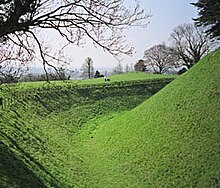
In early fortifications, ditches were often used in combination with ramparts to slow down the enemy whilst defensive fire could be brought to bear from the relative protection afforded by the rampart and possibly the palisade. In medieval fortification, a ditch was often constructed in front of a defensive wall to hinder mining and escalade activities from an attacker. When filled with water, such a defensive ditch is called a moat. However, moats may also be dry.

Later star forts designed by military engineers like Vauban, comprised elaborate networks of ditches and parapets, carefully calculated so that the soil for the raised earthworks was provided, as nearly as possible, entirely by the excavations whilst also maximising defensive firepower.

Today ditches are obsolescent as an anti-personnel obstacle, but are still often used as anti-vehicle obstacles (see also berm).

A fence concealed in a ditch is called a ha-ha.

Elements of a ditch in an artillery fortification (16th to 19th centuries)

A section through the ditch and rampart of a typical early modern artillery fortification (16th to 19th centuries). The elements are: a) glacis, b) banquette, c) covered way or covertway d) counterscarp, e) ditch (dry), f) cunette, g) scarp or escarp, h) faussebraye, i) chemin de ronde, j) rampart (exterior slope), k) parapet, m) terreplein. Fortification - ditch and rampart.png
A section through the ditch and rampart of a typical early modern artillery fortification (16th to 19th centuries). The elements are: a) glacis, b) banquette, c) covered way or covertway d) counterscarp, e) ditch (dry), f) cunette, g) scarp or escarp, h) faussebraye, i) chemin de ronde, j) rampart (exterior slope), k) parapet, m) terreplein.

See also

Related Research Articles

<span class="mw-page-title-main">Glacis</span> Protective slope built into a fortification

A glacis in military engineering is an artificial slope as part of a medieval castle or in early modern fortresses. They may be constructed of earth as a temporary structure or of stone in more permanent structure. More generally, a glacis is any slope, natural or artificial, which fulfils the above requirements. The etymology of this French word suggests a slope made dangerous with ice, hence the relationship with glacier.

<span class="mw-page-title-main">Fortification</span> Military defensive construction

A fortification is a military construction or building designed for the defense of territories in warfare, and is also used to establish rule in a region during peacetime. The term is derived from Latin fortis ("strong") and facere.

<span class="mw-page-title-main">Bastion</span> Outward structure of a fortification

A bastion or bulwark is a structure projecting outward from the curtain wall of a fortification, most commonly angular in shape and positioned at the corners of the fort. The fully developed bastion consists of two faces and two flanks, with fire from the flanks being able to protect the curtain wall and the adjacent bastions. Compared with the medieval fortified towers they replaced, bastion fortifications offered a greater degree of passive resistance and more scope for ranged defence in the age of gunpowder artillery. As military architecture, the bastion is one element in the style of fortification dominant from the mid 16th to mid 19th centuries.

<span class="mw-page-title-main">Littlehampton Redoubt</span> Fort at entrance to the River Arun at Littlehampton

Littlehampton Redoubt, usually known as Littlehampton Fort, was built in 1854 to protect the entrance to the River Arun at Littlehampton on the south coast of England, against possible attack by the French under the Emperor Napoleon III. There had been a previous battery on the east bank of the river, but the new fort was built on the west bank. It consisted of a platform from which cannon could sweep the harbour mouth, with a barracks behind and a surrounding defensive ditch and wall. The fort was an innovative military structure, incorporating the new feature of a Carnot wall. Its active use as a fort was short at only about 20 years, owing to technical changes in armaments, but it was a precursor of the later Palmerston Forts and therefore is NOT the First Palmerston Fort as has been alleged. The Palmerston Forts were built after the 1860 commission. Littlehampton Fort is now in a ruinous and overgrown state but largely protected by the Ivy that now grows over the walls.

<span class="mw-page-title-main">Fort Luton</span>

Fort Luton was built between 1876 and 1892 south of Chatham, Medway, South East England. It is one of the five late Victorian land front forts built to defend the overland approaches to Chatham. It is the smallest of the Chatham forts and was built near to the village of Luton.

<span class="mw-page-title-main">Fort Delimara</span>

Fort Delimara is a polygonal fort in Marsaxlokk, Malta. It was built between 1876 and 1888 by the British as part of a chain of fortifications intended to protect Marsaxlokk Harbour. Today, the fort is still intact but is in need of restoration, and is in danger of collapse due to coastal erosion.

<span class="mw-page-title-main">Bastion fort</span> Early modern fortification style built to withstand cannon fire

A bastion fort or trace italienne is a fortification in a style that evolved during the early modern period of gunpowder when the cannon came to dominate the battlefield. It was first seen in the mid-fifteenth century in Italy. Some types, especially when combined with ravelins and other outworks, resembled the related star fort of the same era.

<span class="mw-page-title-main">Counterscarp</span> Outer side of a ditch or moat in a fortification

A scarp and a counterscarp are the inner and outer sides, respectively, of a ditch or moat used in fortifications. Attackers must descend the counterscarp and ascend the scarp. In permanent fortifications the scarp and counterscarp may be encased in stone. In less permanent fortifications, the counterscarp may be lined with paling fence set at an angle so as to give no cover to the attackers but to make advancing and retreating more difficult.

<span class="mw-page-title-main">Forts in India</span>

The existence of the earliest forts in India have been substantiated by documentation and excavation. In the medieval times, the architecture of the forts had both Hindu and Muslim influence. The forts constructed by the British initially opted for simple designs. The existing castles are continually modified and many of them are privately owned.

<span class="mw-page-title-main">Victoria Lines</span> Line of fortifications in Malta

The Victoria Lines, originally known as the North West Front, are a line of fortifications that spans 12 kilometres along the width of Malta, dividing the north of the island from the more heavily populated south.

<span class="mw-page-title-main">Séré de Rivières system</span> Fortifications in France

The Séré de Rivières system was named after Raymond Adolphe Séré de Rivières, its originator. The system was an ensemble of fortifications built from 1874 along the frontiers and coasts of France. The fortresses were obsolescent by 1914 but were used during the First World War.

<span class="mw-page-title-main">Citadel of Besançon</span> Building in Besançon, France

The Citadel of Besançon is a 17th-century fortress in Franche-Comté, France. It is one of the finest masterpieces of military architecture designed by Sébastien Le Prestre de Vauban. The Citadel occupies 11 hectares on Mount Saint-Etienne, one of the seven hills that protect Besançon, the capital of Franche-Comté. Mount Saint-Etienne occupies the neck of an oxbow formed by the river Doubs, giving the site a strategic importance that Julius Caesar recognised as early as 58 BC. The Citadel overlooks the old quarter of the city, which is located within the oxbow, and has views of the city and its surroundings.

<span class="mw-page-title-main">Thiers wall</span> Former defensive wall in Paris

The Thiers wall was the last of the defensive walls of Paris. It was an enclosure constructed between 1841 and 1846 and was proposed by the French prime minister Adolphe Thiers but was actually implemented by his successor. The 33 kilometres (21 mi) long wall and ditch made a complete circuit around the city as it stood at the time of the July Monarchy. It was bombarded by the Prussian Army during the Franco-Prussian War, captured by government troops during the Paris Commune and refortified at the start of the First World War. However, by then it had become obsolete as a fortification, was a barrier to the expansion of the city, and the area immediately outside of it, known as "the zone", had become a shanty town. The wall was demolished in the interwar period; its path today can be traced by the Boulevards of the Marshals which originally ran just behind the fortifications and by the Boulevard Périphérique which was later built just outside. A few remnants of the wall can still be seen.

<span class="mw-page-title-main">Carnot wall</span>

A Carnot wall is a type of loop-holed wall built in the ditch of a fort or redoubt. It takes its name from the French mathematician, politician, and military engineer, Lazare Carnot. Such walls were introduced into the design of fortifications from the early nineteenth century. As conceived by Carnot they formed part of an innovative but controversial system of fortification intended to defend against artillery and infantry attack. Carnot walls were employed, together with other elements of Carnot's system, in continental Europe in the years after the final defeat of Napoleon in 1815, especially by the Prussians, other Germans and Austrians. Their adoption was initially resisted by the French themselves and by the British.

<span class="mw-page-title-main">Twydall Profile</span>

The Twydall Profile was a style of fortification used in British and Imperial polygonal forts at the end of the 19th century. The sloping earthworks employed in the Twydall Profile were intended to be quick and inexpensive to construct and to be effective in the face of the more powerful artillery and high explosive ammunition being introduced at that time. The name comes from the village of Twydall in Kent, where the first forts of this type were built.

<span class="mw-page-title-main">Rampart (fortification)</span> Defensive bank or wall surrounding a fortified site, such as a castle or settlement

In fortification architecture, a bank or rampart is a length of embankment or wall forming part of the defensive boundary of a castle, hillfort, settlement or other fortified site. It is usually broad-topped and made of excavated earth and/or masonry.

<span class="mw-page-title-main">Questel Fort</span>

Questel Fort is a redoubt in Brest. It is a fortified structure of the Vauban type. It forms a closed square, with the main entry point placed on the least exposed side. This large quadrangle, 100 meters wide, is located between Fort Keranroux and Fort Penfeld, and is also part of the same fortifications as Fort Montbarey.

<span class="mw-page-title-main">Siege of Ath (1697)</span> 1697 siege during the Nine Years War

The siege of Ath was a siege of the Nine Years' War. The French stockpiled 266,000 French pounds of gunpowder for the siege and used less than half of it. Consumption of other material amounted to 34,000 pounds of lead, 27,050 cannonballs, 3,400 mortar bombs, 950 grenades and 12,000 sandbags. The financial costs were 89,250 French livres. After the garrison's capitulation, 6,000 peasant workers filled up the trenches. Under the terms of surrender, the Allied garrison marched off to freedom and was not taken prisoner. Of the 62 French engineers present, two were killed and seven seriously wounded. This demonstration of French military potency, combined with the successful storming of Barcelona the same year, convinced the Allies to come to terms with France in the treaty of Ryswick, thus ending the war.

<span class="mw-page-title-main">Polygonal fort</span> Type of fortification

A polygonal fort is a type of fortification originating in France in the late 18th century and fully developed in Germany in the first half of the 19th century. Unlike earlier forts, polygonal forts had no bastions, which had proved to be vulnerable. As part of ring fortresses, polygonal forts were generally arranged in a ring around the place they were intended to protect, so that each fort could support its neighbours. The concept of the polygonal fort proved to be adaptable to improvements in the artillery which might be used against them, and they continued to be built and rebuilt well into the 20th century.

References

  1. Hogg, Ian V (1975) Fortress: A History of Military Defence, Macdonald and Jane's, ISBN   0-356-08122-2 (pp. 54-56)
  2. 1 2 "A Glossary of Victorian Military Terms". www.victorianforts.co.uk. Victorian Forts and Artillery. Retrieved 29 May 2016.
  3. Lepage, Jean-Denis G G (2010), Vauban and the French Military Under Louis XIV: An Illustrated History of Fortifications and Strategies, MacFarland & Company Inc, ISBN   978-0-7864-4401-4 (pp. 90-92)