
A defensive wall is a fortification usually used to protect a city, town or other settlement from potential aggressors. The walls can range from simple palisades or earthworks to extensive military fortifications such as curtain walls with towers, bastions and gates for access to the city. From ancient to modern times, they were used to enclose settlements. Generally, these are referred to as city walls or town walls, although there were also walls, such as the Great Wall of China, Walls of Benin, Hadrian's Wall, Anastasian Wall, and the Atlantic Wall, which extended far beyond the borders of a city and were used to enclose regions or mark territorial boundaries. In mountainous terrain, defensive walls such as letzis were used in combination with castles to seal valleys from potential attack. Beyond their defensive utility, many walls also had important symbolic functions – representing the status and independence of the communities they embraced.

A bastion or bulwark is a structure projecting outward from the curtain wall of a fortification, most commonly angular in shape and positioned at the corners of the fort. The fully developed bastion consists of two faces and two flanks, with fire from the flanks being able to protect the curtain wall and the adjacent bastions. Compared with the medieval fortified towers they replaced, bastion fortifications offered a greater degree of passive resistance and more scope for ranged defence in the age of gunpowder artillery. As military architecture, the bastion is one element in the style of fortification dominant from the mid 16th to mid 19th centuries.

A caponier is a type of defensive structure in a fortification. Fire from this point could cover the ditch beyond the curtain wall to deter any attempt to storm the wall. The word originates from the French caponnière, meaning "chicken coop".

Fort Ricasoli is a bastioned fort in Kalkara, Malta, which was built by the Order of Saint John between 1670 and 1698. The fort occupies a promontory known as Gallows' Point and the north shore of Rinella Bay, commanding the entrance to the Grand Harbour along with Fort Saint Elmo. It is the largest fort in Malta and has been on the tentative list of UNESCO World Heritage Sites since 1998, as part of the Knights' Fortifications around the Harbours of Malta.

Fort Saint Elmo is a star fort in Valletta, Malta. It stands on the seaward shore of the Sciberras Peninsula that divides Marsamxett Harbour from Grand Harbour, and commands the entrances to both harbours along with Fort Tigné and Fort Ricasoli. It is best known for its role in the Great Siege of Malta in 1565.

A bastion fort or trace italienne is a fortification in a style that evolved during the early modern period of gunpowder when the cannon came to dominate the battlefield. It was first seen in the mid-fifteenth century in Italy. Some types, especially when combined with ravelins and other outworks, resembled the related star fort of the same era.

Neuf-Brisach is a fortified town and commune of the department of Haut-Rhin in the French region of Alsace. The fortified town was intended to guard the border between France and the Holy Roman Empire and, subsequently, the German states. It was built after the Treaty of Ryswick in 1697 that resulted in France losing the town of Breisach, on the opposite bank of the Rhine. The town's name means New Breisach.

The Floriana Lines are a line of fortifications in Floriana, Malta, which surround the fortifications of Valletta and form the capital city's outer defences. Construction of the lines began in 1636 and they were named after the military engineer who designed them, Pietro Paolo Floriani. The Floriana Lines were modified throughout the course of the 17th and 18th centuries, and they saw use during the French blockade of 1798–1800. Today, the fortifications are still largely intact but rather dilapidated and in need of restoration.
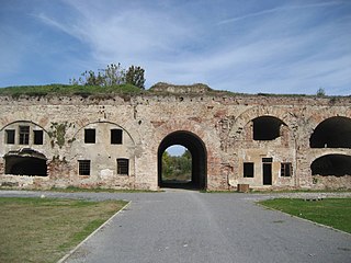
The Fortress of Brod is a fortress in Slavonski Brod, Croatia with significant cultural heritage. The fortress was constructed in the 18th century by the Archduchy of Austria to create a defense against the Ottoman Empire.

Fort Chambray or Fort Chambrai is a bastioned fort located in the precincts of Għajnsielem, on the island of Gozo, Malta. It was built in the mid-18th century by the Order of Saint John, in an area known as Ras it-Tafal, between the port of Mġarr and Xatt l-Aħmar. The fort was meant to be the citadel of a new city which was to replace the Cittadella as the island's capital, but this plan never materialized.

The fortifications of the former East Prussian capital Königsberg consist of numerous defensive walls, forts, bastions and other structures. They make up the First and the Second Defensive Belt, built in 1626—1634 and 1843—1859, respectively. The 15 metre-thick First Belt was erected due to Königsberg's vulnerability during the Polish–Swedish wars. The Second Belt was largely constructed on the place of the first one, which was in a bad condition. The new belt included twelve bastions, three ravelins, seven spoil banks and two fortresses, surrounded by a water moat. Ten brick gates served as entrances and passages through defensive lines and were equipped with moveable bridges.

The Castle/Fortress of Almeida is a castle situated in the civil parish of Almeida, in the municipality of Almeida in the Portuguese district of Guarda, in the former-northwestern province of Beira Alta. It was constructed in this region due to its significant strategic importance, due to its close proximity to the border between Portugal and Spain. It is classified as a National Monument. The 1810 explosion: the magazine which was the seat of the explosion was in the cathedral adjacent to the castle, not the castle itself as reported in the text.

The North Bastion, formerly the Baluarte San Pablo was part of the fortifications of Gibraltar, in the north of the peninsula, protecting the town against attack from the mainland of Spain. The bastion was based on the older Giralda tower, built in 1309. The bastion, with a mole that extended into the Bay of Gibraltar to the west and a curtain wall stretching to the Rock of Gibraltar on its east, was a key element in the defenses of the peninsula. After the British took Gibraltar in 1704 they further strengthened these fortifications, flooding the land in front and turning the curtain wall into the Grand Battery.

The Gibraltar peninsula, located at the far southern end of Iberia, has great strategic importance as a result of its position by the Strait of Gibraltar where the Mediterranean Sea meets the Atlantic Ocean. It has repeatedly been contested between European and North African powers and has endured fourteen sieges since it was first settled in the 11th century. The peninsula's occupants – Moors, Spanish, and British – have built successive layers of fortifications and defences including walls, bastions, casemates, gun batteries, magazines, tunnels and galleries. At their peak in 1865, the fortifications housed around 681 guns mounted in 110 batteries and positions, guarding all land and sea approaches to Gibraltar. The fortifications continued to be in military use until as late as the 1970s and by the time tunnelling ceased in the late 1960s, over 34 miles (55 km) of galleries had been dug in an area of only 2.6 square miles (6.7 km2).

The counterguard is an outwork in a bastioned fortification system that usually comprises only a low rampart and which is sited in front of the actual fortress moat that runs around the bastions or ravelins. The rampart way of a counterguard is, however, so constructed and at least wide enough that it enables the positioning of guns. An additional ditch in front of it guards the work from a frontal enemy assault. The function of counterguards was to protect the higher ravelin or bastion behind it from direct fire and to delay an attack on it as long as possible. So that the counterguards and the works that they were to protect, could not come under simultaneous fire along the line of the rampart they were not allowed to run parallel to one another.
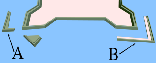
A couvreface in fortification architecture is a small outwork that was built in front of the actual fortress ditch before bastions or ravelins. It usually just consisted of a low rampart with a breastwork that protected its defending infantry. Another ditch in front of the work guarded it from immediate frontal assault. The function of couvrefaces was to protect the faces of the higher ravelin or bastion behind it from direct artillery fire. So that the couvreface and the works behind it could not come under simultaneous fire from an enemy battery along the line of the ramparts they were not allowed to run parallel to one another. Similar to the couvreface is the larger counterguard which, by contrast, was designed to enable the positioning of guns. Couvrefaces are found particularly in Dutch and French fortifications from the 17th to the early 19th centuries.

Gobindgarh Fort is a historic military fort located in the center of the city of Amritsar in the Indian state of Punjab. The Fort was until recently occupied by the Indian Army, but was opened to the public on 10 February 2017. Today the fort is being developed as a museum and theme park, as a repository of Punjab’s history.

The siege of Ath was a siege of the Nine Years' War. The French stockpiled 266,000 French pounds of gunpowder for the siege and used less than half of it. Consumption of other material amounted to 34,000 pounds of lead, 27,050 cannonballs, 3,400 mortar bombs, 950 grenades and 12,000 sandbags. The financial costs were 89,250 French livres. After the garrison's capitulation, 6,000 peasant workers filled up the trenches. Of the 62 French engineers present, two were killed and seven seriously wounded. This demonstration of French military potency, combined with the successful storming of Barcelona the same year, convinced the Allies to come to terms with France in the treaty of Ryswick, thus ending the war.
Timișoara Fortress is a historical fortress in western Romania around which the town of Timișoara was built.

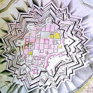
The bastioned system of the Spanish city of Badajoz consists of a military fortification formed by a set of defensive walls, city gates, bridges, forts, towers, bastions, hornworks, moats, tunnels and ravelins, among other defensive elements. It was built between the 17th and 18th centuries, following the defensive construction theories popularized by the French military engineer Sébastien Le Prestre, better known as the Marquis de Vauban, as an extension of a previous defensive enclosure that protected this border town.


