Southport Gates

Last updated

Southport Gates
Puerta de África
Part of Fortifications of Gibraltar
Charles V Wall, Gibraltar
Southport Gates, Gibraltar.jpg
View of New (l) and Old (r) Southport Gates in Charles V Wall, looking north.
Gibraltar Referendum Gates (Southport Gates) 02.jpg
View of Referendum Gate in Charles V Wall, looking south.
Gibraltar location map.svg
Red pog.svg
Southport Gates
Coordinates 36°08′06″N5°21′10″W / 36.134890°N 5.352838°W / 36.134890; -5.352838
Type City Gates
Site information
Owner Government of Gibraltar
Open to
the public
Yes
ConditionGood
Site history
Built1552, 1883, 1967

The Southport Gates are three city gates in the British Overseas Territory of Gibraltar. They are located in the Charles V Wall, one of the 16th century fortifications of Gibraltar. The gates are clustered together, with the South Bastion to the west, and the Trafalgar Cemetery to the east. The first and second Southport Gates were constructed at present day Trafalgar Road in 1552 and 1883, respectively. The third gate, Referendum Gate, is the widest of the three and was constructed in 1967 at Main Street, immediately west of the first two gates. The Southport Gates are listed with the Gibraltar Heritage Trust.

Contents

Description

The Southport Gates are Gibraltar, the British Overseas Territory at the southern end of the Iberian Peninsula. [1] [2] The gates are located in the Charles V Wall, one of the early fortifications of Gibraltar that defended the former southern limit of the city. [3] [4] They are positioned between the South Bastion to the west and the Flat Bastion to the east, at the bottom of Trafalgar Hill, adjacent to the Trafalgar Cemetery (pictured below). [5] [6] [7] The original Southport Gate and the "New" Southport Gate are located at Trafalgar Road, while the most recent of the gates, Referendum Gate, provides access at Main Street. [8] [9] The Southport Gates, together with a rifled muzzle loading ten inch 18 ton gun, are listed with the Gibraltar Heritage Trust. [5]

Southport Gate

The Southport Gate (pictured at right), formerly known as the Africa Gate, was the earliest of the trio of gates in the Charles V Wall. [10] It was constructed by Italian engineer Giovanni Battista Calvi in 1552, under the reign of Charles V, Holy Roman Emperor. [3] [11] [12] The Southport Gate bears the Royal Arms of Charles V, Holy Roman Emperor, as well as the coat of arms of Gibraltar. [13] [14] The gate was depicted in a 1627 map of Gibraltar by Spanish engineer Luis Bravo de Acuña. On the map now held by the British Museum, the Southport Gate and the adjacent Southport Ditch were labeled in Spanish as Puerta de África (English: Africa Gate) and Fosso (English: Ditch), respectively. [15] The Flat Bastion (Spanish : Baluarte de Santiago), the South Bastion (Spanish : Baluarte de Nuestra Señora del Rosario), and Southport Ditch were elements in the defence of the gate and the city. [10] [15] The Southport Ditch was a large trench which extended along the south side of Charles V Wall from the southwestern end of the South Bastion to the Flat Bastion at Prince Edward's Gate. [16]

New Southport Gate

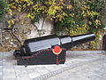
The centre gate was constructed in 1883. [13] [17] The New Southport Gate (pictured above) was opened in the Charles V Wall to improve the flow of traffic. [14] It was constructed during the reign of Queen Victoria and the term of Governor of Gibraltar General Sir John Miller Adye. [14] It is ornamented with the coat of arms of the governor and that of Gibraltar, over which is the Royal Arms of Queen Victoria. [11] [13] [14] In the 19th century, the Southport Ditch was the site of an ordnance depot. In the 1880s, the South Bastion featured four new rifled muzzle loading guns. A magazine was built in Southport Ditch at that time to store the ammunition needed for the new guns. Today, one of the guns (pictured below) is mounted just inside the Southport Gates. By 1908, the magazine had been converted to use as a pumphouse, as demonstrated on an Ordnance Survey map of that year. [16]

Referendum Gate

The third gate, named Referendum Gate (pictured below and at right), is the widest of the three gates. [6] [11] [17] Also referred to as the Referendum Arch, it was built in 1967, to the west of the first two gates. [11] [15] [17] The gate commemorates Gibraltar's first sovereignty referendum of 1967, in which Gibraltarians voted by an overwhelming majority to remain British rather than become Spanish. [6] [11] [13] The western portion of the Southport Ditch had been utilised in the 19th century as a market garden and was known as the Sunken Gardens. At the time that the Referendum Gate was opened, that part of the ditch was filled. [15] [16] Trafalgar Cemetery represents a remnant of the eastern portion of the Southport Ditch, and was formerly referred to as Southport Ditch Cemetery. [14] [15] [16]

Gibraltar National Day, an annual holiday held every 10 September in Gibraltar, also commemorates the referendum of 10 September 1967 in which more than 99% of the votes cast rejected annexation by Spain, favouring the British status quo. The holiday was first celebrated in 1992, the 25th anniversary of the first sovereignty referendum. [18] [19]

Related Research Articles

<span class="mw-page-title-main">Trafalgar Cemetery</span> Cemetery in Gibraltar

The Trafalgar Cemetery is a cemetery in the British Overseas Territory of Gibraltar. Formerly known as the Southport Ditch Cemetery, it occupies a small area of land just to the south of the city walls, in what had been a defensive ditch during the period of Spanish rule of Gibraltar. Although it is named for the Battle of Trafalgar of 21 October 1805, only two victims of the battle are buried there. The remainder of the interments are mostly of those killed in other sea battles or casualties of the yellow fever epidemics that swept Gibraltar between 1804 and 1814. In addition, tombstones were transferred to the Trafalgar Cemetery from St. Jago's Cemetery and Alameda Gardens.

<span class="mw-page-title-main">Flat Bastion Road</span> Road in Gibraltar

Flat Bastion Road is a road in Gibraltar, the British Overseas Territory at the southern end of the Iberian Peninsula. The road runs north–south, providing views of the city and Bay of Gibraltar. Previously known in Spanish as Senda del Moro, the traditional Llanito name for the road is Cuesta de Mr. Bourne.

<span class="mw-page-title-main">Flat Bastion</span> Bastion in Gibraltar

Flat Bastion is a bastion which projects southward from the Charles V Wall in the British Overseas Territory of Gibraltar. Once known as the St. Jago's Bastion or the Baluarte de Santiago in Spanish, the fortification was built by the Spanish in the mid 16th century and formed part of the southern defences of the city of Gibraltar, together with Charles V Wall, Southport Gates, Southport Ditch, and South Bastion. In 1859, six guns, four 12-pounders and two 12-pound carronades, were installed on the bastion, and four years later, five 32-pounders were mounted on the fortification.

St. Jago's Cemetery was a cemetery in the British Overseas Territory of Gibraltar. Also known as Deadman's Cemetery, it was positioned just north of the Charles V Wall. The burial ground was initially used for the poor Spaniards of La Turba; following the 1704 capture of Gibraltar, it was utilised as a Protestant cemetery. In 1929, the burial ground was incorporated into the St. Jago's Barracks recreational facilities. Three years later, some of the remaining headstones were transferred to Trafalgar Cemetery. Little evidence of the former cemetery remains. It is notable as the earliest cemetery in Gibraltar as well as the only one within the city limits.

<span class="mw-page-title-main">Prince Edward's Gate</span>

Prince Edward's Gate is a city gate at the entrance to Prince Edward's Road in the British Overseas Territory of Gibraltar. It cuts through Charles V Wall, one of the 16th century fortifications of Gibraltar at the former southern limit of the city. The gate is adjacent to the west wall of the Flat Bastion, another 16th-century fortification. The gate was named after Prince Edward, the future Duke of Kent, and was opened in 1790, the same year the prince arrived at Gibraltar as commander of the 7th Regiment of Foot. While the gate now has a limited role in the defence of Gibraltar, it continues to provide vehicular and pedestrian access through Charles V Wall. Prince Edward's Gate is listed with the Gibraltar Heritage Trust.

<span class="mw-page-title-main">Flat Bastion Magazine</span>

The Flat Bastion Magazine is a 19th-century magazine in the British Overseas Territory of Gibraltar. It is located within the Flat Bastion, a fortification that projects from the 16th century Charles V Wall at the former southern limit of the city. Flat Bastion Road extends through the bastion, just to the west of the magazine, south of which it becomes Gardiner's Road. Flat Bastion Magazine was constructed to store gunpowder, but eventually lay abandoned for years. While the Government of Gibraltar initially planned to develop it for parking, geology enthusiast Freddie Gomez and a colleague restored the building, which is now used as a geological research facility and exhibition centre. Both the Flat Bastion and the Flat Bastion Magazine are listed with the Gibraltar Heritage Trust. In addition, Gomez received the 2001 Heritage Award for the restoration of the building.

<span class="mw-page-title-main">Orillon</span>

An orillon, also known as an orillion, is an architectural element of a military fortification. The ear-shaped projection of masonry provided defense for guns and soldiers at the flank of a bastion. However, an orillon could also shield a city gate.

<span class="mw-page-title-main">Streets in Gibraltar</span>

Streets in the British Overseas Territory of Gibraltar are represented by road signs as in the United Kingdom. As of 2007, Gibraltar has a network of 29 kilometres (18 mi) of roads.

<span class="mw-page-title-main">Charles V Wall</span> Defensive wall in Gibraltar

The Charles V Wall is a 16th-century defensive curtain wall that forms part of the fortifications of the British Overseas Territory of Gibraltar. Originally called Muralla de San Benito, it was built in 1540 and strengthened in 1552 by Holy Roman Emperor Charles V. The wall remains largely intact and extends from South Bastion, which was once at the water's edge in the harbour, to the top ridge of the Rock of Gibraltar.

<span class="mw-page-title-main">South Bastion, Gibraltar</span> Bastion in Gibraltar

The South Bastion was part of the fortifications of Gibraltar, protecting the western base of the Charles V Wall. It was originally built by Spanish military engineers, later improved by the British. The South Bastion stands at the south end of the Line Wall Curtain which defends the town from attack from the Bay of Gibraltar. Another curtain wall runs east from the bastion to the base of a precipice. This wall is pierced by the Southport Gates, guarded by the South Bastion and the Flat Bastion on either side.

Giovan Giacomo Paleari Fratino (1520–1586), known as El Fratin or Il Fratino, was a military engineer who served the Spanish Emperor Charles V, and then his son Philip II of Spain. He is known for having designed the first Martello tower as well as many other fortifications.

<span class="mw-page-title-main">North Bastion, Gibraltar</span>

The North Bastion, formerly the Baluarte San Pablo was part of the fortifications of Gibraltar, in the north of the peninsula, protecting the town against attack from the mainland of Spain. The bastion was based on the older Giralda tower, built in 1309. The bastion, with a mole that extended into the Bay of Gibraltar to the west and a curtain wall stretching to the Rock of Gibraltar on its east, was a key element in the defenses of the peninsula. After the British took Gibraltar in 1704 they further strengthened these fortifications, flooding the land in front and turning the curtain wall into the Grand Battery.

<span class="mw-page-title-main">Montagu Bastion</span>

The Montagu Bastion is one of many bastions which were designed to protect Gibraltar. Montagu was joined to Orange Bastion by a curtain wall known as Montagu Curtain and this bastion was protected by the Montagu Counterguard.

<span class="mw-page-title-main">Orange Bastion</span>

The Orange Bastion is one of the many bastions in the British Overseas Territory of Gibraltar, which served to protect it against its many sieges. It is located along the Line Wall Curtain and was built to protect Gibraltar Harbour against enemy attack.

<span class="mw-page-title-main">King's Bastion</span>

King's Bastion is a coastal bastion on the western front of the fortifications of the British overseas territory of Gibraltar, protruding from the Line Wall Curtain. It is located between Line Wall Road and Queensway and overlooks the Bay of Gibraltar. It played a crucial role in defending The Rock during the Great Siege of Gibraltar. In more recent history the bastion was converted into a generating station which powered Gibraltar's electricity needs. Today it continues to serve the community as Gibraltar's leisure centre.

<span class="mw-page-title-main">Wellington Front</span>

Wellington Front is a fortification in the British Overseas Territory of Gibraltar. It was built in 1840 on a site established by the Spanish in 1618.

<span class="mw-page-title-main">Ragged Staff Gates</span>

Ragged Staff Gates are a set of city gates in the British Overseas Territory of Gibraltar. They are located between South Bastion and Ragged Staff Guard, opposite the Navy Boat Sheds.

<span class="mw-page-title-main">Fortifications of Gibraltar</span> Defensive military constructions at the Rock of Gibraltar

The Gibraltar peninsula, located at the far southern end of Iberia, has great strategic importance as a result of its position by the Strait of Gibraltar where the Mediterranean Sea meets the Atlantic Ocean. It has repeatedly been contested between European and North African powers and has endured fourteen sieges since it was first settled in the 11th century. The peninsula's occupants – Moors, Spanish, and British – have built successive layers of fortifications and defences including walls, bastions, casemates, gun batteries, magazines, tunnels and galleries. At their peak in 1865, the fortifications housed around 681 guns mounted in 110 batteries and positions, guarding all land and sea approaches to Gibraltar. The fortifications continued to be in military use until as late as the 1970s and by the time tunnelling ceased in the late 1960s, over 34 miles (55 km) of galleries had been dug in an area of only 2.6 square miles (6.7 km2).

<span class="mw-page-title-main">Prince Albert's Front</span>

Prince Albert's Front is a curtain wall that formerly comprised part of the seafront fortifications of Gibraltar. It runs between the King's Bastion and Orange Bastion. The Front was constructed in 1842 after a report by Major General Sir John Thomas Jones recommended improving Gibraltar's seafront defences to guard against the threat of an amphibious assault. It was named after Prince Albert, Queen Victoria's prince consort. The Front straightened out the line of Gibraltar's coastal curtain wall; parts of the original curtain wall, some of which dates from the Moorish period over 500 years ago, can still be seen.

References

  1. "List of Crown Dependencies & Overseas Territories". fco.gov.uk. Foreign and Commonwealth Office . Retrieved 1 October 2012.
  2. Roach, John (13 September 2006). "Neandertals' Last Stand Was in Gibraltar, Study Suggests". National Geographic News. National Geographic Society . Retrieved 1 October 2012.
  3. 1 2 Gilbard, Lieutenant Colonel George James (1881). A popular history of Gibraltar, its institutions, and its neighbourhood on both sides of the Straits, and a guide book to their principal places and objects of interest. Garrison Library Printing Establishment. p. 5. Retrieved 1 October 2012.
  4. "Historical Gibraltar Attractions - Charles V Wall". gibraltarinformation.com. Retrieved 1 October 2012.
  5. 1 2 "Gibraltar Heritage Trust Act 1989" (PDF). gibraltarlaws.gov.gi. Government of Gibraltar . Retrieved 30 September 2012.
  6. 1 2 3 "Historical Gibraltar Attractions (continued)". gibraltarinformation.com. Retrieved 1 October 2012.
  7. Bethune, John Drinkwater (1786). A history of the late siege of Gibraltar (2 ed.). pp. 27–28. Retrieved 1 October 2012.
  8. "Map of the Southport Gates". maps.google.com. Google Maps. Retrieved 1 October 2012.
  9. "Traffic Note". gibraltar.gov.gi. Government of Gibraltar . Retrieved 1 October 2012.
  10. 1 2 Fa, Darren; Finlayson, Clive (31 October 2006). The Fortifications of Gibraltar 1068-1945 (illustrated ed.). Osprey Publishing. p. 21. ISBN   9781846030161 . Retrieved 1 October 2012.
  11. 1 2 3 4 5 "Gates & Fortifications". aboutourrock.com. About Our Rock. Archived from the original on 1 November 2012. Retrieved 1 October 2012.
  12. "The People of Gibraltar - 1740 - Skinner's Moorish Wall". Neville Chipulina. Retrieved 26 September 2012.
  13. 1 2 3 4 "Gates, Walls & Fortifications". Gibraltar Discover Pocket Guide. Discover Pocket Guide(s) Gibraltar Ltd.: 31 July 2009. Retrieved 1 October 2012.
  14. 1 2 3 4 5 "Trafalgar Cemetery". Gibraltar Heritage Trust. Archived from the original on 6 February 2007. Retrieved 30 September 2012.{{cite web}}: CS1 maint: unfit URL (link)
  15. 1 2 3 4 "The New Look at Old Southport Ditch". Gibraltar Chronicle. 11 October 2011. Archived from the original on 14 October 2013. Retrieved 1 October 2012.
  16. 1 2 3 "General Information". docs.google.com. Gibraltar Tourist Board. p. 18. Retrieved 1 October 2012.
  17. "Gibraltar National Day". parliament.uk. UK Parliament. Retrieved 1 October 2012.
  18. "Gibraltar Celebrates 20th National Day". yourgibraltartv.com. Your Gibraltar TV. 11 September 2012. Retrieved 1 October 2012.