
The Royal Gibraltar Regiment is part of British Forces Gibraltar for the British overseas territory of Gibraltar, which historically, along with Bermuda, Halifax, Nova Scotia, and Malta, had been designated an Imperial fortress rather than a colony. It was formed in 1958 from the Gibraltar Defence Force as an infantry unit, with an integrated artillery troop. The regiment is included in the British Army as a defence engagement force.

The Autshumato Anti-Aircraft Regiment is a reserve air defence artillery regiment of the South African Army.
32 Regiment Royal Artillery is a regiment in the Royal Artillery, part of the British Army and is equipped with the PUMA 2 miniature unmanned aerial systems. 32nd Regiment is the only Royal Artillery unit that operates MUAS.

The North Bastion, formerly the Baluarte San Pablo was part of the fortifications of Gibraltar, in the north of the peninsula, protecting the town against attack from the mainland of Spain. The bastion was based on the older Giralda tower, built in 1309. The bastion, with a mole that extended into the Bay of Gibraltar to the west and a curtain wall stretching to the Rock of Gibraltar on its east, was a key element in the defenses of the peninsula. After the British took Gibraltar in 1704 they further strengthened these fortifications, flooding the land in front and turning the curtain wall into the Grand Battery.

The Landport is a gate into the territory of Gibraltar. It was originally the only entrance to the fortification from the land and so was heavily fortified and guarded.

Middle Hill Battery is an artillery battery in the British Overseas Territory of Gibraltar. It is located on Middle Hill, at the northeastern end of the Upper Rock Nature Reserve, just south of Green's Lodge Battery and Rock Gun Battery. The emplacement dates to 1727, when a single gun was mounted. By the turn of the twentieth century, six 10-inch rifled muzzle-loading guns were present at Middle Hill Battery. Other buildings documented at that time as part of the battery complex included the Nursery Hut and the Middle Hill Group, the latter a cluster of buildings which perched on the cliff edge. An anti-aircraft Bofors gun had been installed at the battery by the Second World War. After the war, the area transitioned to use as a Ministry of Defence aerial farm. In 2005, the battery and surrounding area were transferred to the Government of Gibraltar. The site is now managed by the Gibraltar Ornithological and Natural History Society.

Hesse's Demi Bastion is a demi-bastion in the British Overseas Territory of Gibraltar. It is part of the Northern Defences of Gibraltar. The bastion forms a link in a chain of fortifications which ascend the lower north-west slopes of the Rock of Gibraltar, below the King's Lines Battery and Bombproof Battery. The Moorish Castle's Tower of Homage is at the top of the same incline.

Couvreport Battery is an artillery battery in the British Overseas Territory of Gibraltar.

Devil's Tongue Battery was an artillery battery in the British Overseas Territory of Gibraltar. The battery could overlook the harbour but the remains are now surrounded by reclaimed land.

Hanover Battery was an artillery battery on the north west part of the British Overseas Territory of Gibraltar. The battery is casemated. Beneath the battery was a tunnel known as Hanover Gallery.

King's Lines Battery is an artillery battery in the British Overseas Territory of Gibraltar. It was originally built along the access path up to the Gate of Granada.
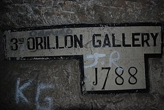
The Orillon Batteries were artillery batteries in the British Overseas Territory of Gibraltar. The batteries were three-storey gun positions within a natural fault in the Rock of Gibraltar.

Queen Charlotte's Battery is a 1727 artillery battery in the British Overseas Territory of Gibraltar.

The Gibraltar peninsula, located at the far southern end of Iberia, has great strategic importance as a result of its position by the Strait of Gibraltar where the Mediterranean Sea meets the Atlantic Ocean. It has repeatedly been contested between European and North African powers and has endured fourteen sieges since it was first settled in the 11th century. The peninsula's occupants – Moors, Spanish, and British – have built successive layers of fortifications and defences including walls, bastions, casemates, gun batteries, magazines, tunnels and galleries. At their peak in 1865, the fortifications housed around 681 guns mounted in 110 batteries and positions, guarding all land and sea approaches to Gibraltar. The fortifications continued to be in military use until as late as the 1970s and by the time tunnelling ceased in the late 1960s, over 34 miles (55 km) of galleries had been dug in an area of only 2.6 square miles (6.7 km2).

The Inundation was a flooded and fortified area of ground on the sandy isthmus between Spain and Gibraltar, created by the British in the 18th century to restrict access to the territory as part of the fortifications of Gibraltar. It was originally a marshy area known as the Morass at the far south-western end of the isthmus, occupying the area adjacent to the north-western flank of the Rock of Gibraltar. The Morass was dug out and expanded to create an artificial lake which was further obstructed by iron and wooden obstacles in the water. Two small fortifications on either side controlled access to Gibraltar. The only road to and from the town ran along a narrow causeway between the Inundation and the sea which was enfiladed by batteries mounted on the lower slopes of the Rock. The Inundation existed for about 200 years before it was infilled and built over after the Second World War.

The King's Lines are a walled rock-cut trench on the lower slopes of the north-west face of the Rock of Gibraltar. Forming part of the Northern Defences of the fortifications of Gibraltar, they were originally created some time during the periods when Gibraltar was under the control of the Moors or Spanish. They are depicted in a 1627 map by Don Luis Bravo de Acuña, which shows their parapet following a tenaille trace. The lines seem to have been altered subsequently, as maps from the start of the 18th century show a more erratic course leading from the Landport, Gibraltar's main land entrance, to the Round Tower, a fortification at their western end. A 1704 map by Johannes Kip calls the Lines the "Communication Line of the Round Tower".
The Queen's Lines are a set of fortified lines, part of the fortifications of Gibraltar, situated on the lower slopes of the north-west face of the Rock of Gibraltar. They occupy a natural ledge which overlooks the landward entrance to Gibraltar and were an extension to the north-east of the King's Lines. They run from a natural fault called the Orillon to a cliff above the modern Laguna Estate, which stands on the site of the Inundation, an artificial lake created to obstruct landward access to Gibraltar. The Prince's Lines run immediately behind and above them on a higher ledge. All three of the Lines were constructed to enfilade attackers approaching Gibraltar's Landport Front from the landward direction.
The Prince's Lines are part of the fortifications of Gibraltar, situated on the lower slopes of the north-west face of the Rock of Gibraltar. They are located at a height of about 70 feet (21 m) on a natural ledge above the Queen's Lines, overlooking the landward entrance to Gibraltar, and run from a natural fault called the Orillon to a cliff at the southern end of the isthmus linking Gibraltar with Spain. The lines face out across the modern Laguna Estate, which stands on the site of the Inundation, an artificial lake created to obstruct landward access to Gibraltar. They were constructed to enfilade attackers approaching Gibraltar's Landport Front from the landward direction.

15th Anti-Aircraft Brigade was an air defence formation of the Royal Artillery which saw service during the middle years of the Second World War. The brigade was formed in Gibraltar to control those anti-aircraft (AA) units based there and disbanded shortly after the air threat had been diminished in 1944. The brigade was later reformed in 1947 as part of the post-war regular army, but disbanded in 1957 following the end of the AA era.

Lord Salisbury described Malta, Gibraltar, Bermuda, and Halifax as Imperial fortresses at the 1887 Colonial Conference, though by that point they had been so designated for decades. Later historians have also given the title "imperial fortress" to St. Helena and Mauritius.


