Grand Casemates Gates

Last updated

Grand Casemates Gates
Casemates Gates
Part of Fortifications of Gibraltar
Grand Casemates Square, Gibraltar
Grand Casemates Gates.jpg
Outside view of Grand Casemates Gates as seen from Market Place.
1597 - Unknown - Map and Fortifications of Gibraltar.jpg
Fortifications of Gibraltar in 1597 (north is to the left in this map). The Old Mole, extending into the bay, is in the lower left. The enclosure above the base of the mole was the shipyard. The gate from the yard to the base of the mole is just visible.
Gibraltar location map.svg
Red pog.svg
Grand Casemates Gates
Coordinates 36°08′43″N5°21′11″W / 36.145248°N 5.353075°W / 36.145248; -5.353075
Site information
Owner Government of Gibraltar
Open to
the public
Yes
Site history
Built1727 (1727)
Materials

Grand Casemates Gates, formerly Waterport Gate, provide an entrance from the northwest to the old, fortified portion of the city of the British Overseas Territory of Gibraltar, at Grand Casemates Square.

Contents

Background

The Rock of Gibraltar, linked to mainland Spain by a low isthmus, extends south into the Strait of Gibraltar which connects the Mediterranean Sea with the Atlantic Ocean. It is a strategic location that has been occupied in turn by the Moors, Spanish and British. The Rock is inaccessible on its eastern side, which rises in a tall and steep cliff. The town lies on the west side along the shore of the Bay of Gibraltar. [1] For many years a gate provided access from the sea into the northwest of the town through the defensive wall that ran along the shore of the bay. [2]

The Moors occupied Gibraltar for centuries until Ferdinand IV of Castile took Gibraltar in the 1309 siege. [3] In 1333 the Moors retook Gibraltar after a lengthy siege. [4] The Spanish regained Gibraltar in August 1462 during its eighth siege. [5] In 1704, during the War of the Spanish Succession, a combined Anglo-Dutch force captured the town of Gibraltar. In 1713 Spain ceded the Rock to the British "in perpetuity". Over the years that followed the British made extensive improvements to the defenses. [6]

Moorish and Spanish structures

The northern approaches to the town were defended by a Moorish Castle on the slopes of The Rock, from which walls ran down to the shore of the Bay of Gibraltar. [7] Around 1310 Ferdinand IV ordered the Giralda Tower to be built on the coast at the west end of the wall to protect the dockyard. [3] The Moors built a line wall, running south from the tower along the bay's western shore, which the Spanish later improved. [8] The Giralda Tower was converted into the North Bastion by the Italian engineer Giovan Giacomo Paleari Fratino in the 1560s. [9]

The esplanade just south of the tower is now Grand Casemates Square. It was a walled area where the Moors built their galleys. These were launched through a large arch in the line wall just north of today's Grand Casemates Gates, leading to the Waterport. [8] The Moorish Sea Gate (Spanish : Puerta del Mar) provided one of the three access gates to La Barcina, the shipbuilding area that is now Grand Casemates Square. The others were the Land Gate (Spanish : Puerta de Tierra now Landport Gate) and a southern gate, the Barcina Gate, through a wall that no longer exists. [2]

The Old Mole extending into the bay from a point just south of the tower provided shelter for trading vessels. [10] The mole provided an anchoring line for the galleys. An aqueduct ran from a well to the south along the line wall to the Waterport, where it replenished a reservoir from which water for the galleys was drawn. [11]

British developments

The British built the Line Wall Curtain in the 18th century running north–south along the shore of the bay. [12] It incorporates, and is to some extent built upon, older Spanish and Moorish fragments. [12] The Line Wall Curtain runs from the North Bastion south along the western coast of the town to Engineer Battery, just south of the New Mole. It protected the town from bombardment from ships in the bay and from troops landing from the sea. [13] The Moorish Sea Gate in the old line wall lay just north of today's Grand Casemates Gates, and was closed up. [8] The Waterport Gate, providing access to the town through the Line Wall from the shore south of North Bastion, was opened by the British in 1727. [14]

The Waterport Gate was the main entrance to Gibraltar in the early days of British occupation, described in 1748 as consisting

mainly of one street extending from Southport gate to Waterport Gate. Out of this long street run several shorter ones one of which, called the Irish-Street is of ill repute. The buildings of this town are generally mean and low, very few houses being above one story high. They are chiefly made of stone and the roof covered with Spanish tiles. The shops are small and ... are occupied by Genoese, Jews and Turks. Profane swearing and cursing is extremely common... [15]

In 1802 Prince Edward, Duke of Kent and Strathearn was appointed Governor of Gibraltar. A disciplinarian, he forced constant drills and training, and was rigid about uniforms and was even concerned with beards and haircuts. [16] When he went as far as to order closure of the taverns in the town, an ill-planned mutiny broke out. The climax occurred at Waterport gate, where a gunner recalled that his captain ordered the artillery to "reverse [the] guns that were pointing to the Spanish lines, and point them on my comrade soldiers, who but a short time before had been fighting with me in Egypt." The mutineers scattered and were later rounded up and confined to their quarters. [17]

The Grand Casemates, a bombproof barracks, was started in the 1770s but was not finished until 1817. [18] In 1815 two gateways were opened in the wall at the Waterport, so that carriages could pass through in both directions at once. [19]

Ceremony of the Keys

Sir Francis Richards at the Ceremony of the Keys in May 2005 Governor of Gibraltar Sir Francis Richards - 2005.jpg
Sir Francis Richards at the Ceremony of the Keys in May 2005

During the Great Siege of Gibraltar, from 1779 to 1783, the Port Sergeant was responsible for locking the gates of the fortress at sunset. The Governor, General George Augustus Eliott, wore the keys of the gates at all other times, and the keys took on significance as a symbol of office. [20] The ceremony continued after the siege. An 1881 travel book described the keys being received from the governor twice daily and marched under escort to the gates, which were opened in the morning and closed each evening by a senior officer. [21] The ceremony is mentioned by Molly Bloom in James Joyce's novel Ulysses , referring to some time before 1888. [22] It is mentioned again in a 1908 description of Gibraltar. [23]

After the armistice that ended World War I the future United States Admiral Jerauld Wright was a lieutenant on a destroyer that showed the flag in the Mediterranean. In Gibraltar, he was struck by a squad of troops performing the ceremony, "...one had a limp and all were obviously Somme veterans. There were two fifers, one drummer, and one little fellow following with those gigantic keys... they swung past, boots pounding, heads in the air, fife and drum rolling..." [24] Vice-Admiral Kenneth Dewar was in Gibraltar in 1928. In his memoir The navy from within he wrote, "All the Spanish labourers employed on the breakwater had to return to Spanish territory by sunset. After the closing of the gates, a drum-and-fife band awoke the echoes in the narrow streets, accompanying a strong military guard which escorted the keys of the fortress to the Governor's Palace..." [25]

The practice was discontinued for a while, then revived as an annual Ceremony of the Keys by General Sir Charles Harington when he took office as governor in 1933. [26] [27] The keys were ceremonially presented to his successor Governor Ironside every evening. [28] Today, a version of the ceremony is staged in Casemates Square at noon every Saturday by actors in uniforms similar to those worn by the defenders during the Great Siege. [29] The full military ceremony is held just twice a year. [30] [31] In this ceremony, recalling the Great Siege, the gates of the fortress are symbolically locked. The Governor hands the keys to the Port Sergeant, who is accompanied by an armed escort, and he locks the gates. [27] The keys are then handed back to the governor. [32] Following tradition, drums and fifes accompany the Port Sergeant's party. [33]

In 2005 the Ceremony of the Keys was held on 19 May, and was attended by the governor and commander in chief, Sir Francis Richards. [34] The ceremony was again held in May during the term of office of his successor, Lieutenant General Sir Robert Fulton. [35] In October 2010 the escort was dressed in the uniform of the Black Watch, a highland regiment. [36] The Port Sergeant is ceremonial Custodian of the Keys. [37] In July 2012 a ceremony was staged in which the outgoing Port Sergeant handed the keys over to his successor. [38] On 6 September 2012 Governor Sir Adrian Johns inspected the parade of the Royal Gibraltar Regiment at the ceremony. [39] On this occasion, a group of young drummers performed in Casemates Square for ten minutes before the Parade. [40]

Related Research Articles

Main Street, Gibraltar

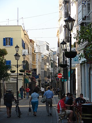
Main Street is the main arterial street in the British overseas territory of Gibraltar.

History of Gibraltar History of a peninsula on the Iberian coast

The history of Gibraltar, a small peninsula on the southern Iberian coast near the entrance of the Mediterranean Sea, spans over 2,900 years. The peninsula has evolved from a place of reverence in ancient times into "one of the most densely fortified and fought-over places in Europe", as one historian has put it. Gibraltar's location has given it an outsized significance in the history of Europe and its fortified town, established in the Middle Ages, has hosted garrisons that sustained numerous sieges and battles over the centuries.

Line Wall Curtain

The Line Wall Curtain is a defensive curtain wall that forms part of the fortifications of the British Overseas Territory of Gibraltar.

Streets in Gibraltar

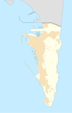
Streets in the British Overseas Territory of Gibraltar are represented by road signs as in the United Kingdom. As of 2007, Gibraltar has a network of 29 kilometres (18 mi) of roads.

South Bastion, Gibraltar Bastion in Gibraltar

The South Bastion was part of the fortifications of Gibraltar, protecting the western base of the Charles V Wall. It was originally built by Spanish military engineers, later improved by the British. The South Bastion stands at the south end of the Line Wall Curtain which defends the town from attack from the Bay of Gibraltar. Another curtain wall runs east from the bastion to the base of a precipice. This wall is pierced by the Southport Gates, guarded by the South Bastion and the Flat Bastion on either side.

Moorish Gibraltar Overview of Gibraltar under the Moors

The history of Moorish Gibraltar began with the landing of the Muslims in Hispania and the fall of the Visigothic Kingdom of Toledo in 711 and ended with the fall of Gibraltar to Christian hands 751 years later, in 1462, with an interregnum during the early 14th century.

Moorish Wall

The Moorish Wall, also known as the Philip II Wall and formerly the Muralla de San Reymondo is a defensive curtain wall built in the 16th century that formed part of the southern fortifications of the British Overseas Territory of Gibraltar. It was completed by 1575. The wall ran from the top of a steep cliff above the lower section of the Charles V Wall up the slope of the Rock of Gibraltar to its crest, north of the upper section of the Charles V Wall and is now within the Upper Rock Nature Reserve.

North Bastion, Gibraltar

The North Bastion, formerly the Baluarte San Pablo was part of the fortifications of Gibraltar, in the north of the peninsula, protecting the town against attack from the mainland of Spain. The bastion was based on the older Giralda tower, built in 1309. The bastion, with a mole that extended into the Bay of Gibraltar to the west and a curtain wall stretching to the Rock of Gibraltar on its east, was a key element in the defenses of the peninsula. After the British took Gibraltar in 1704 they further strengthened these fortifications, flooding the land in front and turning the curtain wall into the Grand Battery.

Grand Casemates Square Square in Gibraltar

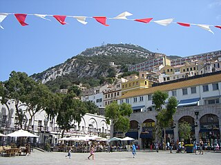
Grand Casemates Square is the larger of the two main squares within the city centre of Gibraltar. The square takes its name from the British-built Grand Casemates, a casemate and bombproof barracks at the northern end of the square completed in 1817.

The eighth siege of Gibraltar (1462) was a successful effort by soldiers of the Kingdom of Castile to take the fortified town of Gibraltar from the Moors of the Emirate of Granada. Capture of this position, which was weakly defended and was taken with little fighting, was strategically important in the final defeat of the Moors in Spain.

Kings Bastion

King's Bastion is a coastal bastion on the western front of the fortifications of the British overseas territory of Gibraltar, protruding from the Line Wall Curtain. It is located between Line Wall Road and Queensway and overlooks the Bay of Gibraltar. It played a crucial role in defending The Rock during the Great Siege of Gibraltar. In more recent history the bastion was converted into a generating station which powered Gibraltar's electricity needs. Today it continues to serve the community as Gibraltar's leisure centre.

Castle Batteries

Castle Batteries are a series of artillery batteries that are part of the Northern Defences of the British Overseas Territory of Gibraltar. The batteries descend from the Moorish Castle to end at the sixth and seven batteries which are known as Crutchett's Batteries. There are brick vaulted bombproof rooms (casemates) under Crutchets Battery.

Fortifications of Gibraltar Defensive military constructions at the Rock of Gibraltar

The Gibraltar peninsula, located at the far southern end of Iberia, has great strategic importance as a result of its position by the Strait of Gibraltar where the Mediterranean Sea meets the Atlantic Ocean. It has repeatedly been contested between European and North African powers and has endured fourteen sieges since it was first settled in the 11th century. The peninsula's occupants – Moors, Spanish, and British – have built successive layers of fortifications and defences including walls, bastions, casemates, gun batteries, magazines, tunnels and galleries. At their peak in 1865, the fortifications housed around 681 guns mounted in 110 batteries and positions, guarding all land and sea approaches to Gibraltar. The fortifications continued to be in military use until as late as the 1970s and by the time tunnelling ceased in the late 1960s, over 34 miles (55 km) of galleries had been dug in an area of only 2.6 square miles (6.7 km2).

Lines of Contravallation of Gibraltar

The Lines of Contravallation of Gibraltar, known in English as the "Spanish Lines", were a set of fortifications built by the Spanish across the northern part of the isthmus linking Spain with Gibraltar. They later gave their name to the Spanish town of La Línea de la Concepción. The Lines were constructed after 1730 to establish a defensive barrier across the peninsula, with the aim of preventing any British incursions, and to serve as a base for fresh Spanish attempts to retake Gibraltar. They played an important role in the Great Siege of Gibraltar between 1779 and 1783 when they supported the unsuccessful French and Spanish assault on the British-held fortress. The siege was ended after the lines of contravallation were attacked by British and Dutch forces under the command of the Governor of Gibraltar, General Augustus Eliot. The attack caused the Spanish forces to retreat and abandon the fortifications and the combined British led forces virtually destroyed all the Spanish gun batteries and the enemy cannon and munitions either captured or destroyed. This attack is still commemorated to this day and is known as 'Sortie Day'.

Kings Lines

The King's Lines are a walled rock-cut trench on the lower slopes of the north-west face of the Rock of Gibraltar. Forming part of the Northern Defences of the fortifications of Gibraltar, they were originally created some time during the periods when Gibraltar was under the control of the Moors or Spanish. They are depicted in a 1627 map by Don Luis Bravo de Acuña, which shows their parapet following a tenaille trace. The lines seem to have been altered subsequently, as maps from the start of the 18th century show a more erratic course leading from the Landport, Gibraltar's main land entrance, to the Round Tower, a fortification at their western end. A 1704 map by Johannes Kip calls the Lines the "Communication Line of the Round Tower".

Queens Lines

The Queen's Lines are a set of fortified lines, part of the fortifications of Gibraltar, situated on the lower slopes of the north-west face of the Rock of Gibraltar. They occupy a natural ledge which overlooks the landward entrance to Gibraltar and were an extension to the north-east of the King's Lines. They run from a natural fault called the Orillon to a cliff above the modern Laguna Estate, which stands on the site of the Inundation, an artificial lake created to obstruct landward access to Gibraltar. The Prince's Lines run immediately behind and above them on a higher ledge. All three of the Lines were constructed to enfilade attackers approaching Gibraltar's Landport Front from the landward direction.

Princes Lines

The Prince's Lines are part of the fortifications of Gibraltar, situated on the lower slopes of the north-west face of the Rock of Gibraltar. They are located at a height of about 70 feet (21 m) on a natural ledge above the Queen's Lines, overlooking the landward entrance to Gibraltar, and run from a natural fault called the Orillon to a cliff at the southern end of the isthmus linking Gibraltar with Spain. The lines face out across the modern Laguna Estate, which stands on the site of the Inundation, an artificial lake created to obstruct landward access to Gibraltar. They were constructed to enfilade attackers approaching Gibraltar's Landport Front from the landward direction.

Ceremony of the Keys (Gibraltar)

The Ceremony of the Keys event is a re-enactment of the locking of the gates to the old Town and garrison of Gibraltar.

Battle of the Strait was a military conflict contesting the ports in the Straits of Gibraltar taking place in the late thirteenth century and the first half of the fourteenth. The conflict involves principally the Spanish Muslim Emirate of Granada, the Spanish Christian Crown of Castile and the North African Muslim Marinid state. The ports' strategic value came from their position linking Spain and North Africa, thus connecting Muslims in Spain with the rest of the Islamic world. The campaign had mixed results. Castile gained Tarifa permanently, and managed to take Gibraltar and Algeciras but both would revert to Muslim rule. Castile also failed to gain any port in the African side of the strait.

References

Citations

  1. Heriot 1792, p. 11ff.
  2. 1 2 Fa & Finlayson 2006, p. 12.
  3. 1 2 Harvey 1996, p. 37.
  4. Royal Engineers Journal 1910, p. 171.
  5. Fothergill Jackson 1987, p. 57-58.
  6. Fa & Finlayson 2006, p. 9-10.
  7. Gibraltar.
  8. 1 2 3 James 1771, p. 403.
  9. Fa & Finlayson 2006, p. 19.
  10. Drinkwater 1786, p. 29.
  11. James 1771, p. 345.
  12. 1 2 Ehlen & Harmon 2001, p. 110.
  13. Fa & Finlayson 2006, p. 8.
  14. Gibraltar - Main Sights.
  15. Poole 1748.
  16. Musteen 2005, p. 95-96.
  17. Musteen 2005, p. 97.
  18. Casemate Square.
  19. Musteen 2005, p. 227.
  20. Archer 2006, p. 154.
  21. Picturesque Europe 1881, p. 50.
  22. Raleigh 1977, p. 57.
  23. Howells 1908, p. 22.
  24. Key 2001, p. 44-45.
  25. Dewar 1939, p. 36.
  26. Naval Review 1941.
  27. 1 2 Cox 2012.
  28. Life goes calling ...
  29. Chartrand 2006, p. 91.
  30. June 20th 2009 - Today in Gibraltar.
  31. Fodor's 2011, p. 830.
  32. Chilton 2012, p. 180.
  33. Sep 06 - Ceremony.
  34. Ceremony of the Keys - Chronicle 2005.
  35. Gibraltar - The Ceremony of The Keys - eportbic.
  36. Gibraltar Ceremony of the Keys - Blipfoto.
  37. New Port Sergeant.
  38. Official Handover of the Keys.
  39. Ceremony of the Keys - Chronicle 2012.
  40. Ceremony of the Keys at new Grand Battery hall.

Sources

External links