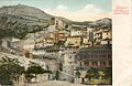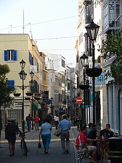
Main Street is the main arterial street in the British overseas territory of Gibraltar.

Gibraltar National Day, celebrated annually on 10 September, is the official national day of the British overseas territory of Gibraltar. The day commemorates Gibraltar's first sovereignty referendum of 1967, in which Gibraltarian voters were asked whether they wished to either pass under Spanish sovereignty, or remain under British sovereignty, with institutions of self-government.

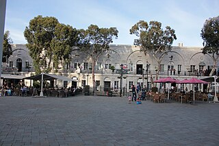
John Mackintosh Square is a main square in the British overseas territory of Gibraltar. It has been the centre of city life since the 14th century and takes its name from John Mackintosh, a local philanthropist. Notable buildings on John Mackintosh Square include the Parliament Building and the City Hall.
The Line Wall Curtain is a defensive curtain wall that forms part of the fortifications of the British Overseas Territory of Gibraltar.

Streets in the British Overseas Territory of Gibraltar are represented by road signs as in the United Kingdom. As of 2007, Gibraltar has a network of 29 kilometres (18 mi) of roads.

Grand Casemates Gates, formerly Waterport Gate, provide an entrance from the northwest to the old, fortified portion of the city of the British Overseas Territory of Gibraltar, at Grand Casemates Square.

The history of Moorish Gibraltar began with the landing of the Muslims in Hispania and the fall of the Visigothic Kingdom of Toledo in 711 and ended with the fall of Gibraltar to Christian hands 751 years later, in 1462, with an interregnum during the early 14th century.

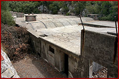
The North Bastion, formerly the Baluarte San Pablo was part of the fortifications of Gibraltar, in the north of the peninsula, protecting the town against attack from the mainland of Spain. The bastion was based on the older Giralda tower, built in 1309. The bastion, with a mole that extended into the Bay of Gibraltar to the west and a curtain wall stretching to the Rock of Gibraltar on its east, was a key element in the defenses of the peninsula. After the British took Gibraltar in 1704 they further strengthened these fortifications, flooding the land in front and turning the curtain wall into the Grand Battery.
The Grand Casemates is a building in Grand Casemates Square, Gibraltar, that was originally a fortified barracks and casemate. It is beside Grand Casemates Gates, which leads through the former town wall.

The fourth siege of Gibraltar, fought from June until August 1333, pitted a Christian army under King Alfonso XI of Castile against a large Moorish army led by Muhammed IV of Granada and Abd al-Malik Abd al-Wahid of Fes. It followed on immediately from the third siege of Gibraltar, fought earlier in 1333. The siege began inauspiciously with a disastrous landing by Castilian forces on the west side of Gibraltar, before developing into a stalemate in which neither side had the strength to capture Gibraltar, nor to break out or lift the siege. Both sides faced acute shortages of food – the Gibraltar garrison was cut off from resupply, while the Castilians, deep within enemy territory, could only be resupplied via an unreliable sea route. After two months of inconclusive siege warfare, the Castilians and Moors reached a truce agreement that allowed both sides to make an honourable exit from the siege. Although the Moors managed to keep Gibraltar, the truce cost Muhammed IV his life when he was assassinated by disgruntled nobles the day after signing it.
Abu Malik Abd al-Wahid was a son of the Marinid sultan of Morocco, Abu al-Hasan Ali ibn Othman. Although he had lost an eye, Malik was a capable military commander and served as governor of Algeciras and the Marinids' principal general in Al Andalus. He captured Gibraltar from Castile in June 1333 and participated in his father's campaign against rebels in the Kingdom of Tlemcen the following year. He was killed by Castilian forces in 1339 after being ambushed on the way back from a raid against the Castilian-held town of Jerez de la Frontera.

The fifth siege of Gibraltar, mounted between August 1349 and March 1350, was a second attempt by King Alfonso XI of Castile to retake the fortified town of Gibraltar. It had been held by the Moors since 1333. The siege followed years of intermittent conflict between the Christian kingdoms of Spain and the Moorish Emirate of Granada, which was supported by the Marinid sultanate of Morocco. A series of Moorish defeats and reverses had left Gibraltar as a Moorish-held enclave within Castilian territory. Its geographical isolation was compensated for by the strength of its fortifications, which had been greatly improved since 1333. Alfonso brought an army of around 20,000 men, along with his mistress and their five illegitimate children, to dig in to the north of Gibraltar for a lengthy siege. In the New Year of 1350, however, bubonic plague – the Black Death – broke out in the Castilian camp. Alfonso refused to abandon the siege but fell victim to the plague on 27 March 1350, becoming the only monarch to die of the disease.

King's Bastion is a coastal bastion on the western front of the fortifications of the British overseas territory of Gibraltar, protruding from the Line Wall Curtain. It is located between Line Wall Road and Queensway and overlooks the Bay of Gibraltar. It played a crucial role in defending The Rock during the Great Siege of Gibraltar. In more recent history the bastion was converted into a generating station which powered Gibraltar's electricity needs. Today it continues to serve the community as Gibraltar's leisure centre.

Castle Batteries are a series of artillery batteries that are part of the Northern Defences of the British Overseas Territory of Gibraltar. The batteries descend from the Moorish Castle to end at the sixth and seven batteries which are known as Crutchett's Batteries. There are brick vaulted bombproof rooms (casemates) under Crutchets Battery.

Town Range is a major road in the British Overseas Territory of Gibraltar. It is located in the old town area and runs parallel to Main Street and part of Prince Edward's Road. It is also known in Spanish as Calle Cuartel, in reference to the barracks constructed on the street in 1740. It is one of the three main parallel streets in the old town and is likely to date back to the Moorish period. Until the mid-19th century it was notorious for its filthiness due to wholly inadequate sanitation and lack of any running water supply. It was the point of outbreak of Gibraltar's devastating 1804 epidemic of yellow fever, which killed a third of the territory's population. The street is now a residential and commercial area notable for several important public buildings in addition to the old Georgian barracks, which have been converted for civilian use.

The Gibraltar peninsula, located at the far southern end of Iberia, has great strategic importance as a result of its position by the Strait of Gibraltar where the Mediterranean Sea meets the Atlantic Ocean. It has repeatedly been contested between European and North African powers and has endured fourteen sieges since it was first settled in the 11th century. The peninsula's occupants – Moors, Spanish, and British – have built successive layers of fortifications and defences including walls, bastions, casemates, gun batteries, magazines, tunnels and galleries. At their peak in 1865, the fortifications housed around 681 guns mounted in 110 batteries and positions, guarding all land and sea approaches to Gibraltar. The fortifications continued to be in military use until as late as the 1970s and by the time tunnelling ceased in the late 1960s, over 34 miles (55 km) of galleries had been dug in an area of only 2.6 square miles (6.7 km2).
Willis' Magazine is an 18th-century large magazine in the British Overseas Territory of Gibraltar. The magazine sits on a plateau with several artillery batteries.
Battle of the Strait was a military conflict contesting the ports in the Straits of Gibraltar taking place in the late thirteenth century and the first half of the fourteenth. The conflict involves principally the Spanish Muslim Emirate of Granada, the Spanish Christian Crown of Castile and the North African Muslim Marinid state. The ports' strategic value came from their position linking Spain and North Africa, thus connecting Muslims in Spain with the rest of the Islamic world. The campaign had mixed results. Castile gained Tarifa permanently, and managed to take Gibraltar and Algeciras but both would revert to Muslim rule. Castile also failed to gain any port in the African side of the strait.