
The Rock of Gibraltar is a monolithic limestone mountain 426 m (1,398 ft) high dominating the western entrance to the Mediterranean Sea. It is situated near the end of a narrow 9 kilometres (5.6 mi) long promontory stretching due south into the Mediterranean Sea and is located within the British territory of Gibraltar, and is 27 km north-east of Tarifa, Spain, the southwestern tip of Europe on the Iberian Peninsula. The rock serves as an impregnable fortress and contains a labyrinthine network of man-made tunnels known as the Tunnels of Gibraltar. Most of the Rock's upper area comprises a nature reserve which is home to about 300 Barbary macaques. It is a major tourist attraction.
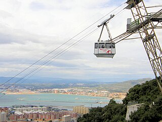
Gibraltar Cable Car is an aerial tramway in Gibraltar. The base station of the cable car is located near the southern end of Main Street, next to Alameda Gardens.

The Gibraltar Nature Reserve is a protected nature reserve in the British Overseas Territory of Gibraltar that covers over 40% of the territory's land area. It was established as the Upper Rock Nature Reserve in 1993 under the International Union for Conservation of Nature's category Ia and was last extended in 2013. It is known for its semi-wild population of Barbary macaques, and is an important resting point for migrating birds.

Princess Caroline's Battery is an artillery battery in the British Overseas Territory of Gibraltar. It is located at the northern end of the Upper Rock Nature Reserve, at the junction of Willis's Road and Queen's Road. The nearby Princess Anne's Battery is often mistakenly referred to as Princess Caroline's Battery. The latter was built in 1732 and named after Princess Caroline, the daughter of King George II. Princess Caroline's Battery was updated in 1905, and a 6 inch Mark VII gun was mounted above the magazine. Later, the battery was decommissioned and the gun removed. The underground magazine is now home to the Military Heritage Centre, which includes the Memorial Chamber.

Princess Anne's Battery is an artillery battery in the British Overseas Territory of Gibraltar. It is located on Willis's Plateau at the northern end of the Upper Rock Nature Reserve, below Princess Caroline's Battery. It was named after Anne, Princess Royal and Princess of Orange, the eldest daughter of George II. However, its name is often confused with those of other batteries in the area. In 1732, guns were first mounted on the battery, which also saw action during the Great Siege of Gibraltar. Princess Anne's Battery was updated in the nineteenth and twentieth centuries, with the latter modernisation entailing the installation of four QF 5.25 inch guns with both anti-aircraft and coastal defence capabilities. The battery was manned into the early 1980s, after which it was decommissioned. The guns were refurbished in the early twenty-first century, and represent the world's only intact battery of 5.25 inch anti-aircraft guns. Princess Anne's and Amelia’s Battery are listed with the Gibraltar Heritage Trust.
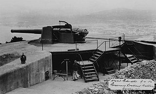
O'Hara's Battery is an artillery battery in the British Overseas Territory of Gibraltar. It is located at the highest point of the Rock of Gibraltar, near the southern end of the Upper Rock Nature Reserve, in close proximity to Lord Airey's Battery. It was constructed in 1890 at the former site of a watchtower that had earned the name O'Hara's Folly. The battery and tower were both named after the Governor of Gibraltar Charles O'Hara. The first gun mounted on the battery was a 6-inch breech loading gun, which was replaced with a 9.2 inch Mark X BL gun in 1901. The battery was in use during World War II and was last fired during training exercises in 1976. O'Hara's Battery has been refurbished and is open to the public. The battery and its associated works are listed with the Gibraltar Heritage Trust.

Breakneck Battery is an artillery battery in the British Overseas Territory of Gibraltar. It is located on Ministry of Defence property at the Upper Rock Nature Reserve, north of Lord Airey's Battery. It is one of a dozen batteries in Gibraltar that had 9.2-inch (233.7 mm) guns installed around the turn of the twentieth century. The emplacement features a 9.2-inch Mark X breech-loading gun on a Mark V mounting. The battery was refurbished by 10 Signal Regiment in 2012 and 2016 whilst being on Ceremonial duties whilst the Gibraltar Regiment where on exercise and is one of three surviving 9.2-inch gun emplacements at the Upper Ridge of the Rock of Gibraltar. By the late twentieth century, the 9.2-inch guns in Gibraltar, Bermuda, Portugal, South Africa, and Australia were the remaining examples of an emplacement that at one point had been mounted at strategic locations across the British Empire.

Green's Lodge Battery is an artillery battery in the British Overseas Territory of Gibraltar. It is located on the North Face of the Rock of Gibraltar at the northern end of the Upper Rock Nature Reserve, above Farringdon's Battery. Also known as the Superior Battery, it was named after General Sir William Green, who served in Gibraltar for twenty-two years, most of them as the chief engineer of Gibraltar. In 1776, guns were first mounted on the battery, which also saw action during the Great Siege of Gibraltar. The emplacement also underwent reconstruction in the early and mid twentieth century. Green's Lodge Battery is listed with the Gibraltar Heritage Trust.

General Sir William Green, 1st Baronet, of Marass, Kent was an officer in the British Army.

Rock Gun Battery is an artillery battery in the British Overseas Territory of Gibraltar. It is located on the North Face of the Rock of Gibraltar at the northern end of the Upper Rock Nature Reserve, above Green's Lodge Battery. The emplacement on Middle Hill is at the northern summit of the Rock. It was constructed during the Great Siege of Gibraltar, due to its advantageous position and the success of the gun at Green's Lodge Battery. It was used effectively during the Great Siege and was rebuilt during the Second World War. During the mid-twentieth century, the Ministry of Defence began to use the site as an aerial farm, which was then refurbished in 1958. The Rock Gun Battery and the Middle Hill Battery were closed to the public for decades. In 2005, the radio farm was closed and the Ministry of Defence withdrew from most of the area, transferring it to the Government of Gibraltar. However, the summit, the site of the Rock Gun Battery, continues to be under MOD authority.

Middle Hill is a hill in the British Overseas Territory of Gibraltar. It is located at the northern end of the Upper Rock Nature Reserve. It figured prominently in the early history of the 1704 siege of Gibraltar by the Spanish and French. The artillery battery at Middle Hill had been constructed by 1727 and was active for more than two centuries. In the mid twentieth century, Middle Hill transitioned to use as an aerial farm for the Ministry of Defence. The radio farm was refurbished in 1958. About 1970, the Princess Caroline's Battery Group of Barbary macaques were moved to Middle Hill, where they were provisioned at a group of derelict buildings that were part of the battery complex. In 2005, much of Middle Hill was transferred from the Ministry of Defence to the Government of Gibraltar, and is now managed by the Gibraltar Ornithological and Natural History Society.

Middle Hill Battery is an artillery battery in the British Overseas Territory of Gibraltar. It is located on Middle Hill, at the northeastern end of the Upper Rock Nature Reserve, just south of Green's Lodge Battery and Rock Gun Battery. The emplacement dates to 1727, when a single gun was mounted. By the turn of the twentieth century, six 10-inch rifled muzzle-loading guns were present at Middle Hill Battery. Other buildings documented at that time as part of the battery complex included the Nursery Hut and the Middle Hill Group, the latter a cluster of buildings which perched on the cliff edge. An anti-aircraft Bofors gun had been installed at the battery by the Second World War. After the war, the area transitioned to use as a Ministry of Defence aerial farm. In 2005, the battery and surrounding area were transferred to the Government of Gibraltar. The site is now managed by the Gibraltar Ornithological and Natural History Society.

Signal Hill Battery or Signal Battery was an artillery battery in the British Overseas Territory of Gibraltar. The battery was mounted high on the rock. Little remains today as the Gibraltar Cable Car top station was built on the site of the old battery.
Governor's Lookout Battery is one of the many artillery batteries in the British Overseas Territory of Gibraltar, which served to protect it against its many sieges. It is located off Signal Station Road within the Upper Rock Nature Reserve.
Devil's Gap Road is a street in the British Overseas Territory of Gibraltar.

The Gibraltar peninsula, located at the far southern end of Iberia, has great strategic importance as a result of its position by the Strait of Gibraltar where the Mediterranean Sea meets the Atlantic Ocean. It has repeatedly been contested between European and North African powers and has endured fourteen sieges since it was first settled in the 11th century. The peninsula's occupants – Moors, Spanish, and British – have built successive layers of fortifications and defences including walls, bastions, casemates, gun batteries, magazines, tunnels and galleries. At their peak in 1865, the fortifications housed around 681 guns mounted in 110 batteries and positions, guarding all land and sea approaches to Gibraltar. The fortifications continued to be in military use until as late as the 1970s and by the time tunnelling ceased in the late 1960s, over 34 miles (55 km) of galleries had been dug in an area of only 2.6 square miles (6.7 km2).

The Inundation was a flooded and fortified area of ground on the sandy isthmus between Spain and Gibraltar, created by the British in the 18th century to restrict access to the territory as part of the fortifications of Gibraltar. It was originally a marshy area known as the Morass at the far south-western end of the isthmus, occupying the area adjacent to the north-western flank of the Rock of Gibraltar. The Morass was dug out and expanded to create an artificial lake which was further obstructed by iron and wooden obstacles in the water. Two small fortifications on either side controlled access to Gibraltar. The only road to and from the town ran along a narrow causeway between the Inundation and the sea which was enfiladed by batteries mounted on the lower slopes of the Rock. The Inundation existed for about 200 years before it was infilled and built over after the Second World War.

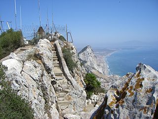
Mediterranean Steps is a path and nature trail in the British Overseas Territory of Gibraltar. One of the footpaths of Gibraltar, the path is located entirely within the Upper Rock Nature Reserve and was built by the British military but is now used by civilians as a pedestrian route linking Martin's Path to Lord Airey's Battery near the summit of Rock of Gibraltar. The path offers views over the Strait of Gibraltar, Windmill Hill, Europa Point, the Great Sand Dune, Gibraltar's east side beaches, the Mediterranean Sea and the Spanish Costa del Sol.

Windmill Hill or Windmill Hill Flats is one of a pair of plateaux, known collectively as the Southern Plateaux, at the southern end of the British Overseas Territory of Gibraltar. It is located just to the south of the Rock of Gibraltar, which descends steeply to the plateau. Windmill Hill slopes down gently to the south with a height varying from 120 metres (390 ft) at the north end to 90 metres (300 ft) at the south end. It covers an area of about 19 hectares, though about 6 hectares at the north end is built over. The plateau is ringed to the south and east with a line of cliffs which descend to the second of the Southern Plateaux, Europa Flats, which is itself ringed by sea cliffs. Both plateaux are the product of marine erosion during the Quaternary period and subsequent tectonic uplift. Windmill Hill was originally on the shoreline and its cliffs were cut by the action of waves, before the ground was uplifted and the shoreline moved further out to the edge of what is now Europa Flats.
The footpaths of Gibraltar provide access to key areas of the Upper Rock Nature Reserve, a refuge for hundreds of species of flora and fauna which in some cases are found nowhere else in Europe. The reserve occupies the upper part of the Rock of Gibraltar, a long and narrow mountain that rises to a maximum height of 424 metres (1,391 ft) above sea level, and constitutes around 40 per cent of Gibraltar's total land area. The unusual geology of the Rock of Gibraltar – a limestone peak adjoining a sandstone hinterland – provides a habitat for plants and animals, such as the Gibraltar candytuft and Barbary partridge, which are found nowhere else in mainland Europe. For many years, the Upper Rock was reserved exclusively for military use; it was fenced off for military purposes, but was decommissioned and converted into a nature reserve in 1993.

